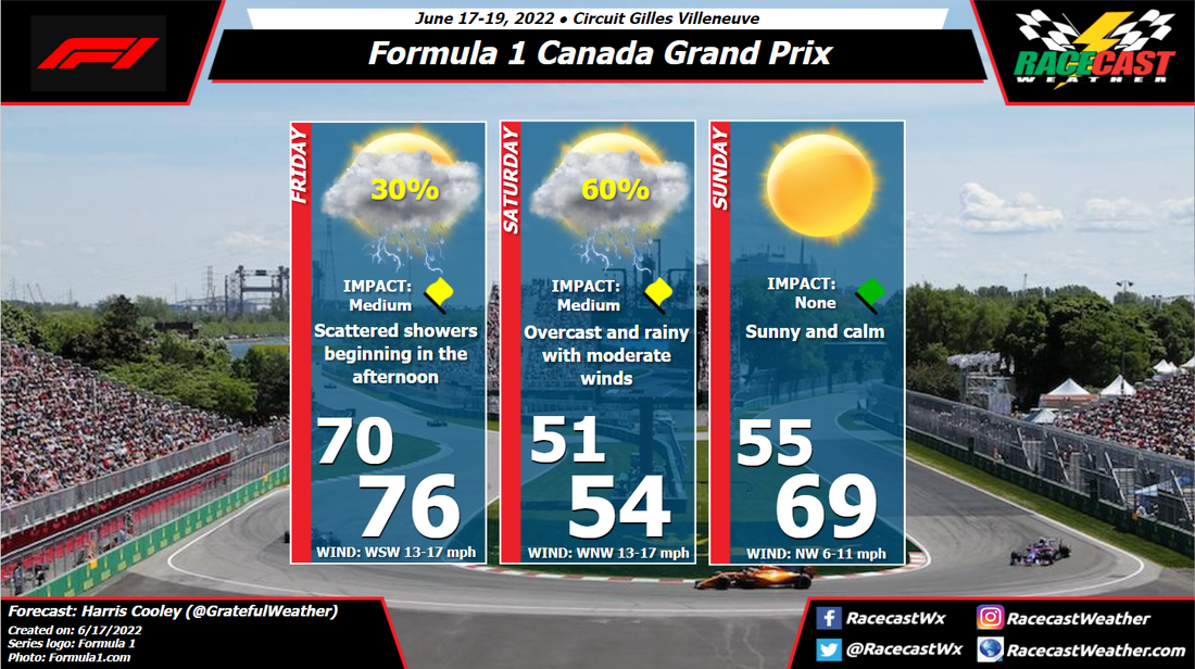
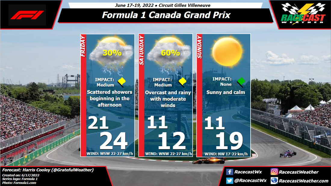
The evil clears out by Sunday for the most part with some lingering instability and moisture that could give way to isolated storms, but chances are low as of now. Wind speeds will be lighter and from the northwest as well, just in time for the race. These conditions should give the teams' some extra variables to take into consideration when forming their strategies, so we are in for a treat this weekend. A metric graphic is displayed below...
|
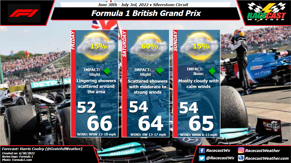
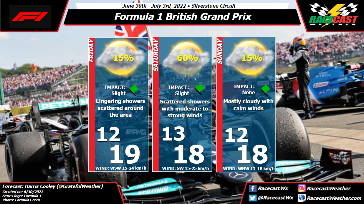
By: Harris Cooley The weather report remains mostly the same as this Low pressure will be passing through the area beginning Friday afternoon through Saturday evening. The pressure gradient will be tight over the area bringing moderate to gusty southwesterly winds and pockets of convection. Strings of storms will be passing through the area so rain chances will be sporadic and scattered. Saturday afternoon presents the largest chance for showers, though these should not be too severe nor long lasting.
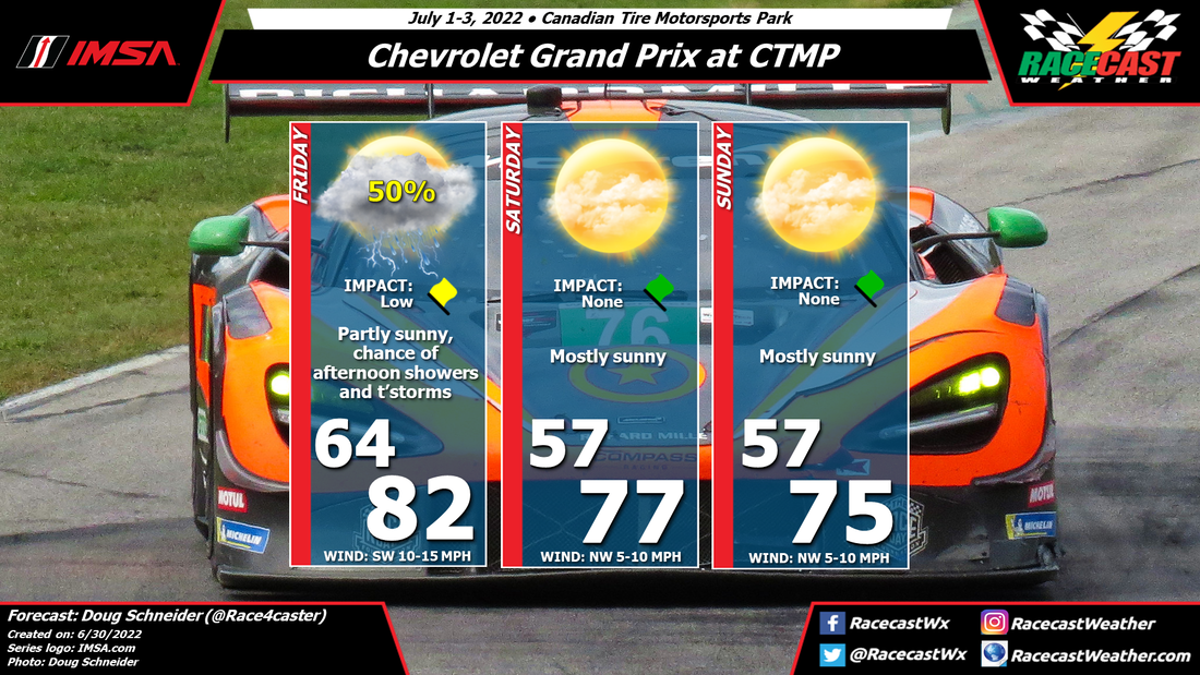
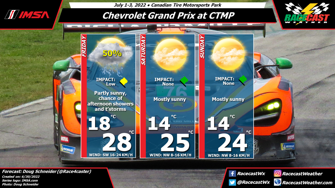
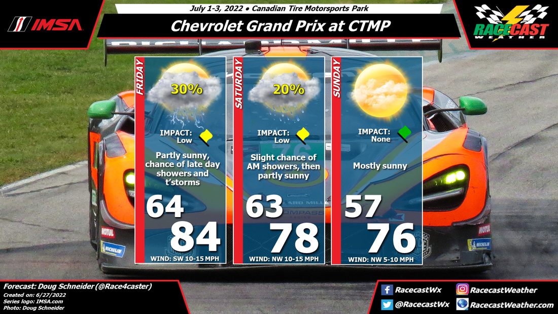
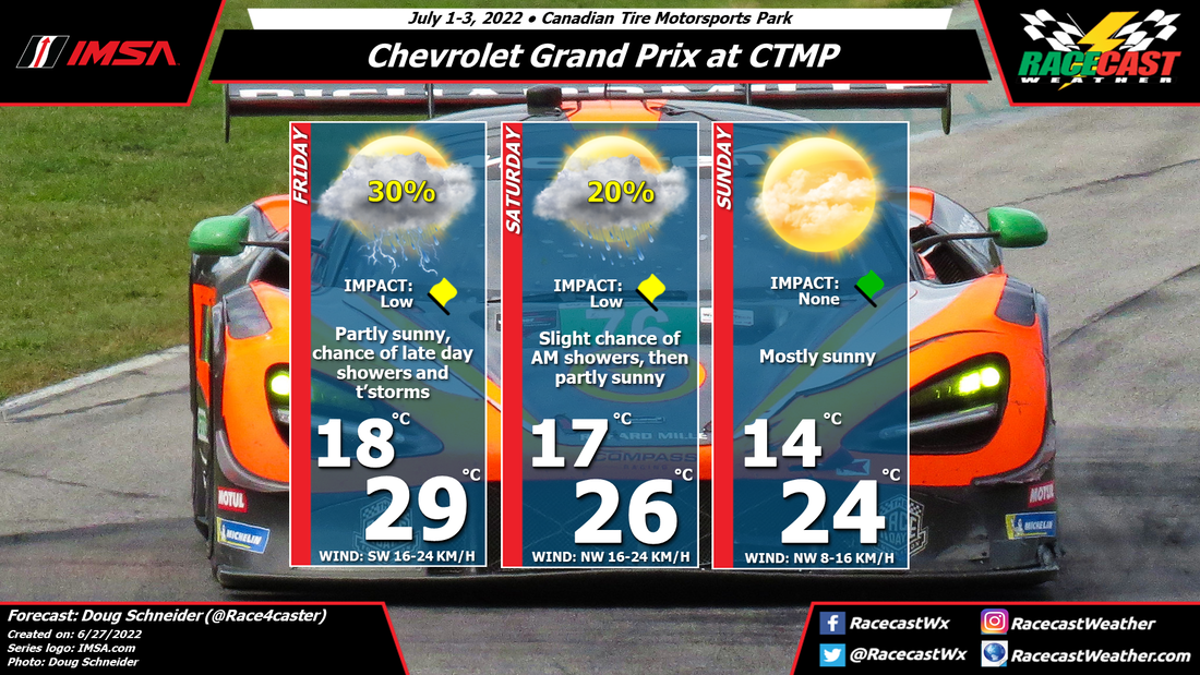
The evil clears out by Sunday for the most part with some lingering instability and moisture that could give way to isolated storms, but chances are low as of now. Wind speeds will be lighter and from the northwest as well, just in time for the race. These conditions should give the teams' some extra variables to take into consideration when forming their strategies, so we are in for a treat this weekend. A metric graphic is displayed below... By Doug Schneider Click images to enlarge An approaching cold front will bring showers and thunderstorms to CTMP on Friday afternoon. The likely time frame for showers on Friday starts at 2 pm, but the majority of showers are expected to occur in the evening, after the end of on-track activity.
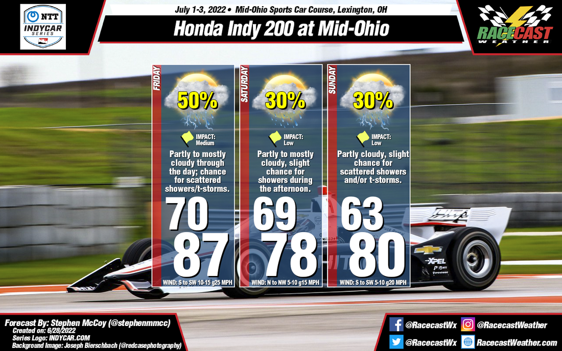
The front will push through on Friday night, and rain will be gone by the time on-track activity starts on Saturday morning. As high pressure builds over the area, Saturday will be a beautiful day with mostly sunny skies and highs in the upper 70s F, or mid 20s C. Sunday looks much the same. Should be a great weekend to attend the race. By: Stephen McCoy There will be a slow moving cold front moving through the region for the weekend, bringing chances for rainfall each day. The greatest chances are expected to occur on Friday into Saturday, ahead of the front. However, due to the speed of the frontal passage, rainfall chances along the front may continue into Sunday. Winds ahead of the front will bring warmer air to the region from the Southwest, causing highs in the upper 80's. Behind the front, winds will shift to the North/Northwest, causing slightly cooler conditions to move in for the remainder of the weekend.
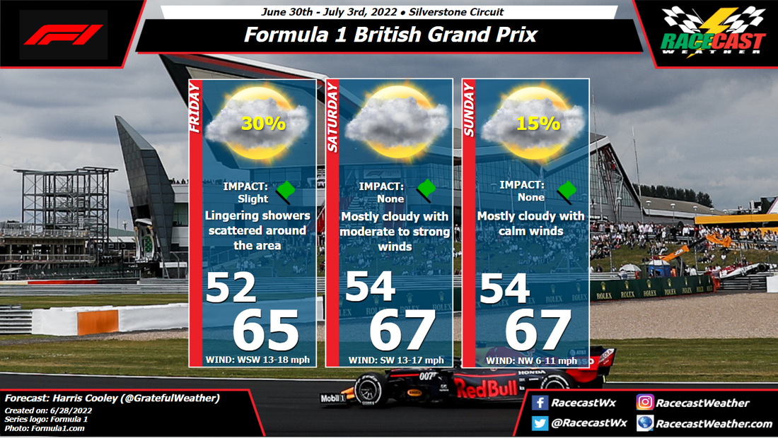
All this being said, some aspects for the forecast may still change between now and the race weekend. While creating this, the ECMWF forecast model switched the greatest chance for rainfall from Saturday to Sunday; the GFS and UK models still continue to show the rainfall on Friday/Saturday. We'll see how this plays out, but (hopefully) the outlook will be more concrete by the next forecast. By: Harris Cooley As we head to Silverstone, a large Low pressure system will be settled in West of the site giving us a chance for some spotty showers into the afternoon. The pressure gradient will be tight over the area giving way to moderate and gusty winds out of the southwest.
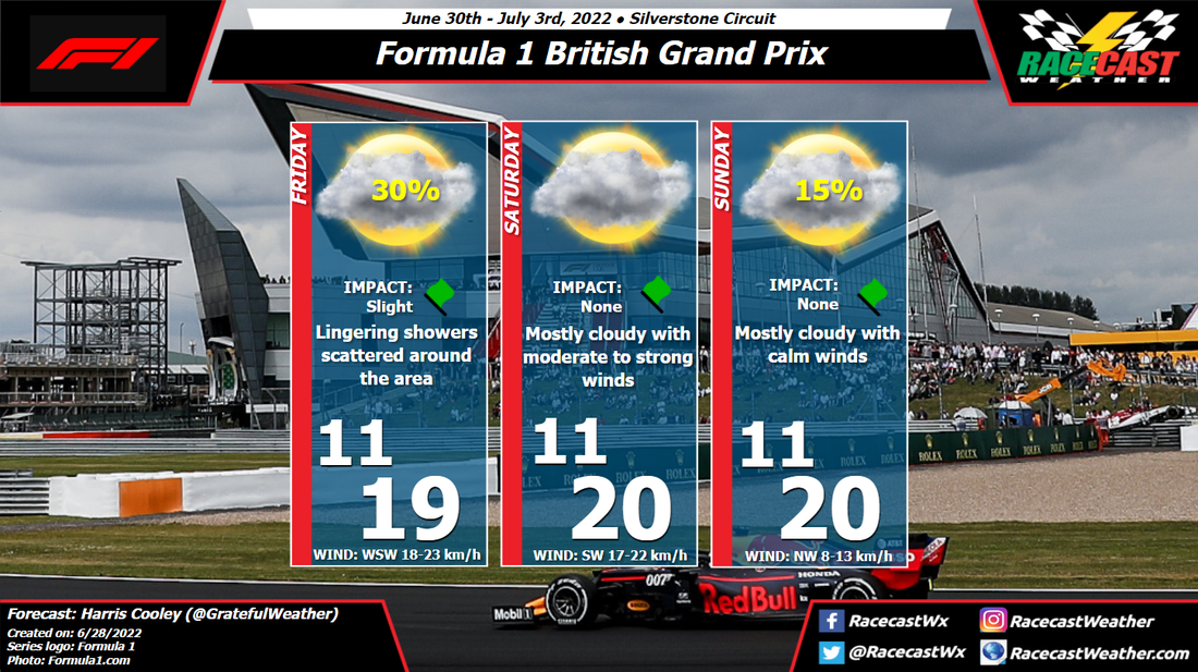
Saturday presents a mostly cloudy day as winds remain southwesterly carrying moisture, but rain chances are near none. By Sunday, the pressure gradient is expected to relax a bit calming wind speeds down and shifting to a more northwesterly direction. A small chance for spotty showers is possible, but we should see some sunshine mixed in there as well. A metric graphic is posted below... By Doug Schneider Click images to enlarge Sometimes making a forecast graphic is difficult to properly reflect what I think the weather will be. This graphic looks like there will be more rain at CTMP this weekend than I expect there to be, due to the uncertain timing of rain associated with a cold front.
A cold front will be moving across the upper Great Lakes on Friday. Showers and thunderstorms along and ahead of the front may be in the Lake Ontario area late Friday afternoon or evening. The final session on Friday is MPC qualifying from 5 pm to 5:45 pm, and it will be close as to whether it is affected by these storms. Right now, I'm putting the chance of rain before 5:45 pm at 30%. I think the bulk of rain will hold off until later in the evening or Friday night. How quickly the front moves through on Friday night will affect the chance of rain on Saturday morning. I have a 20% chance of showers in the forecast for Saturday morning to account for the models that are slower with the front. However, it is possible that the rain with the front may be gone by the time the WeatherTech Championship practice starts at 8 am. Temperatures will be cooler on Saturday, with highs in the upper 70s. Sunday looks like a beautiful day for racing. Drier air builds in behind the front, and I expect mostly sunny skies and temperatures in the mid 70s for the WeatherTech Championship race in the afternoon. By Doug Schneider Click to enlarge The main change to today's forecast update is to add a small chance of showers on Thursday afternoon. Yesterday, I mentioned that showers and thunderstorms are likely on Wednesday night. That is still expected, but the low pressure system is trending slower, which will keep some moisture and instability over the Finger Lakes area into Thursday afternoon. I do not expect that this will be a heavy rain, and I don't expect lightning either, so impacts should be low. But since there are practice sessions on Thursday, and amount of rain may lead to a stoppage.
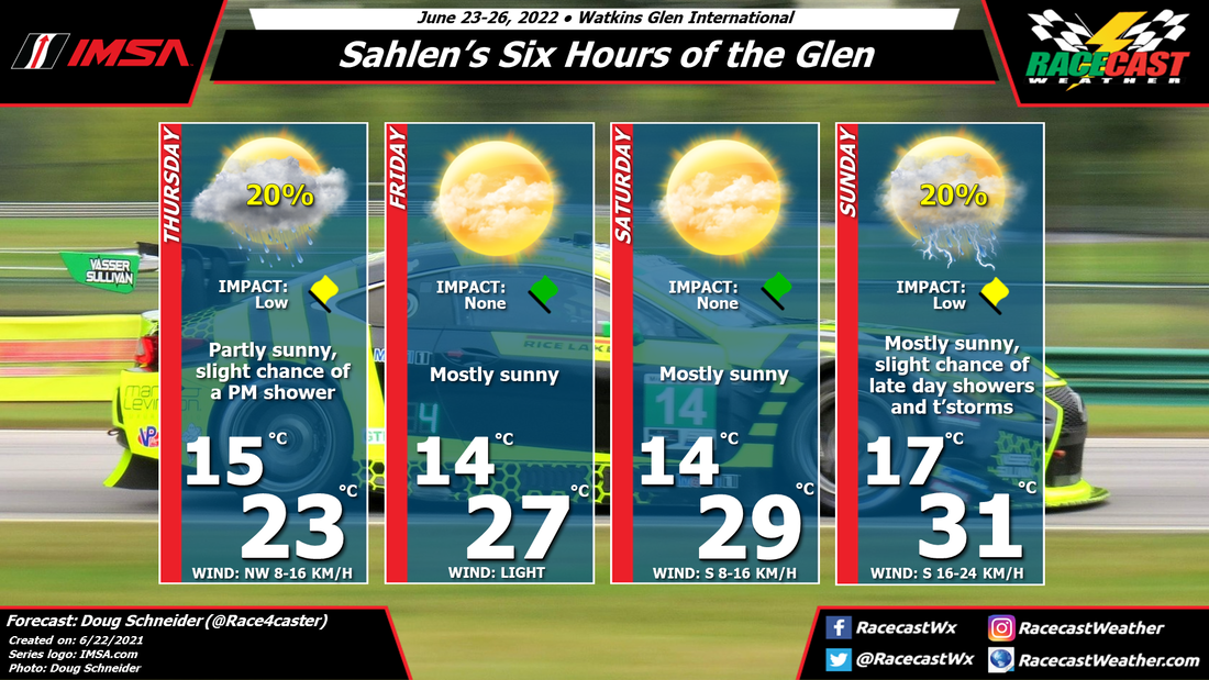
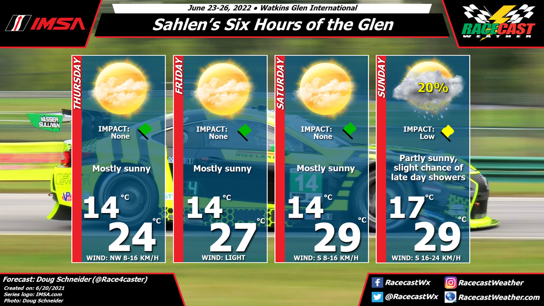
High pressure builds over the area on Thursday night, and will shift east through Friday and Saturday. This will provide nice weather with plenty of sunshine and a warming trend to temperatures as a southerly flow develops. The high pressure ridge weakens on Sunday, and a cold front will approach from the west. The timing of this front still looks like it will be moving through on Sunday night. However, I can't rule out some isolated showers and thunderstorms popping up in the afternoon, ahead of the front. So I will keep the 20% chance of rain in the forecast, but I still think that most of the rain will arrive after the race ends, and impacts on the race are low. By Doug Schneider Click images to enlarge I'm happy to report that the weather looks great for this year's edition of the Sahlen's Six Hours of the Glen. The slight chance of rain on Sunday is uncertain, and it could hold off until after the race is over. More on that below.
On Wednesday and Wednesday night, there will be numerous showers and thunderstorms in the Finger Lakes region of New York as a cold front moves across the area. These showers should be gone by the time practice sessions start on Thursday morning. Temperatures will be very nice on Thursday, with highs in the mid 70s and comfortable humidity levels. Through Friday and Saturday, a large high pressure ridge will be moving across the region from west to east. This will provide mostly sunny skies both days, with temperatures warming into the lower to mid 80s as a southerly flow develops on the west side of the high. Sunday is the day with the most uncertainty, as there will be increasing instability and a low pressure trough approaching from the west. The question is the timing of this system - will showers hold off until after the race ends around 4:40 pm EDT? As of today, I think the most likely scenario is that the rain arrives after the race ends, so I have just a 20% chance in the forecast. This could change as we go through the week, so check back here for updates. By: Harris Cooley The front from the initial forecast has lagged and is set to push through Friday night into Saturday with overcast skies and scattered showers throughout its passage. Wind speeds will be moderate and gusty through Saturday as well beginning as westerlies and shifting more northwesterly by Saturday night.
Sunday presents a much better day as the front will have passed and calmer, drier conditions will prevail. The pressures over the area will be higher and the gradient will remain tight keeping wind speeds light to moderate. Hardly any moisture is expected as the site will be fresh out of a frontal passage. Drivers will have to earn their spot on the grid this weekend and will likely be rewarded with some good weather for Sunday. A metric graphic is posted below... |
Social Feeds
Authors
Doug Schneider Partners
Categories
All
Archives
December 2023
|

