By Doug Schneider
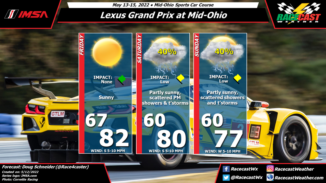
The weather at Road Atlanta late this week will start off hot, but an approaching cold front will bring cooler temperatures through the weekend, but an increasing chance of showers and thunderstorms as well.
High pressure will be located off the Southeast coast for the middle of this week and into Friday, providing warm temperatures in the lower 90s and mostly sunny skies. There could be an isolated afternoon shower in the north Georgia area, but I expect that these will be mainly in the higher terrain to the north of Road Atlanta, and not affect the track.
A cold front will be moving southeast across the Tennessee Valley on Friday, and move across northern Georgia on Friday night. The exact position of the front is uncertain this far out, but as of today it is expected to be to the south of Road Atlanta on Saturday. Because of the uncertainty, I will mention a possibility of afternoon showers and thunderstorms, but only a 20% chance. If the front stalls closer to the track, the chance of rain will be higher.
On Sunday the front should start to push back to the north and the flow above the surface turns to the south, which will bring greater moisture into northern Georgia. As a result, the chance of rain will rise, as will the amount of clouds. Scattered showers and thunderstorms are expected, mainly in the afternoon but are possible at any time of the day. As we get closer to the weekend, rain amounts and potential impacts on the racing will come into better focus. For now, I have rated the impact as low.
Check back on Wednesday for the next update.