By: Stephen McCoy 
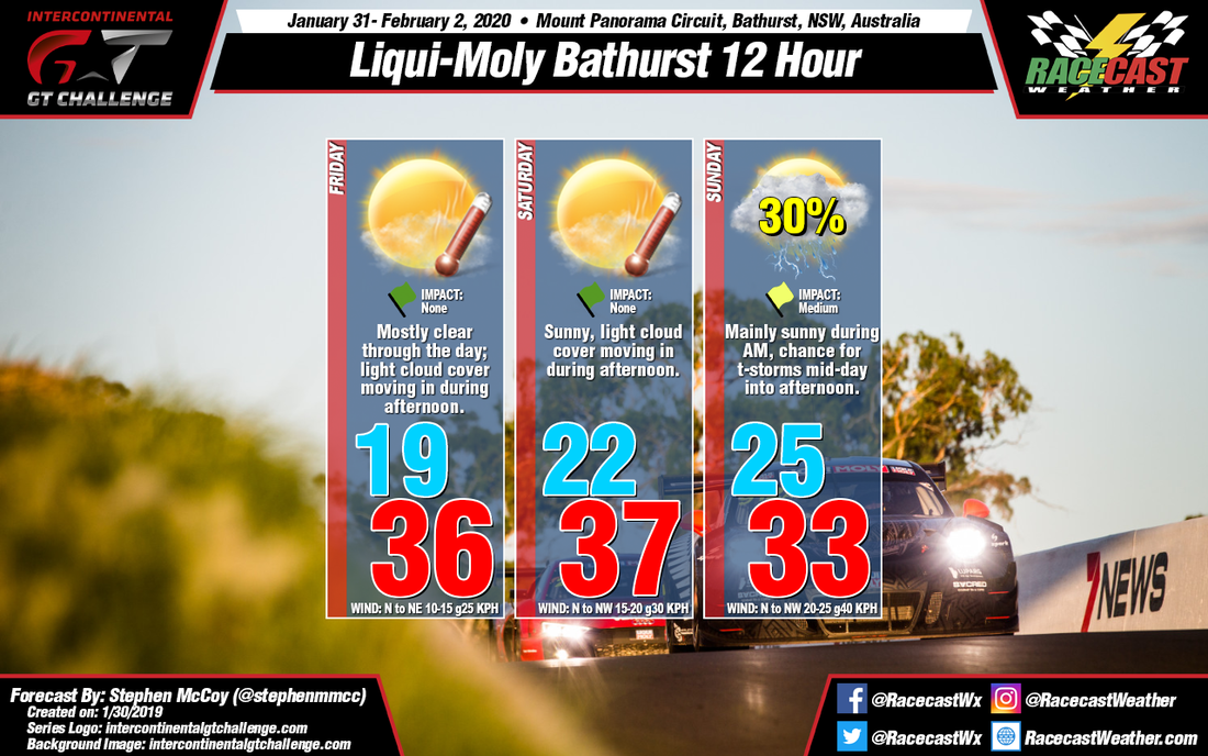
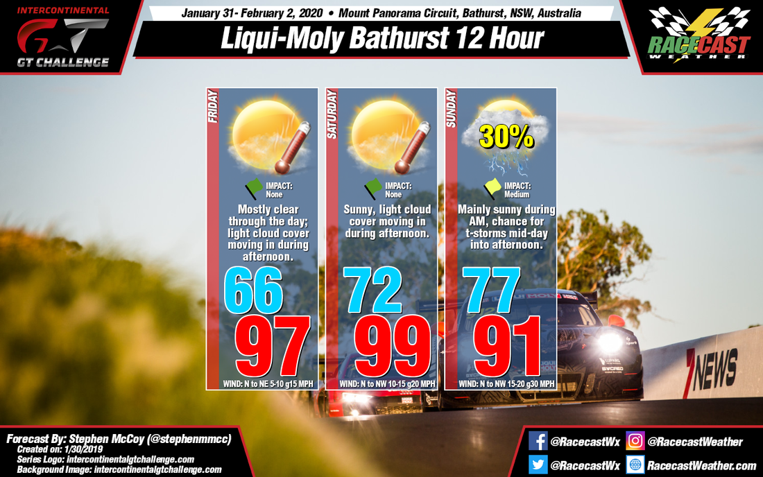
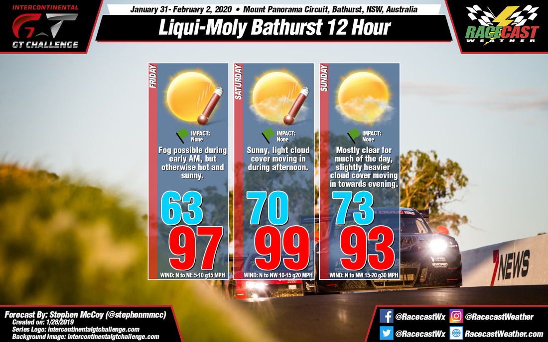
Conditions for the Bathurst 12 Hour remain mostly unchanged except for Sunday, which shows an increase in precipitation chances as the result of a cold front moving through the region. Much like in the initial forecast, a surface high pressure system is expected to sit stationary over the Pacific Ocean off the West coast of Australia. As it brings in warmer air from the North/Northwest, an upper level trough over the New South Wales territory will keep the heat trapped closer to the surface, resulting in temperatures well into the 30's C, 90's F on Friday and Saturday. Where this forecast update differs with the initial is that model guidance now suggests an upper level trough will move to the south of the continent, allowing a low pressure system to form at the surface, moving eastward Saturday into Sunday. A cold front will extend to the Northwest from the system, and is anticipated to move through the NSW region in the early to mid-afternoon on Sunday, bringing with it a chance for scattered showers with some thunderstorms possible. Maximum temperatures reflect the frontal passage, being a few degrees cooler than the rest of the weekend.
By: Stephen McCoy A fairly straight-forward forecast for the Bathurst 12 Hours this weekend: lots of sun and hot temperatures each day. An upper-level ridge will sit over the NSW region with an accompanying surface high pressure system present just off the coast. North to northwesterly winds will bring warmer temperatures to the region, while the ridge will keep the heat trapped nearer to the surface. Northeasterly winds during the morning on Friday will bring in a slight amount of moisture off the Pacific Ocean and could result in some fog, but will any amount will disappear after sunrise. Slight amounts of smoke/haze are possible for the remainder of Friday from bushfires to the south, however the conditions are unlikely to continue for the rest of the weekend. Light cloud cover is expected for Saturday and Sunday as a result of mid level winds from the east, and will increase towards Sunday evening, but overall conditions will remain mostly sunny.
By Scott Martin Other than being a little cool for what you would expect at Daytona International Speedway, you really can't complain about the weather for this year's ROLEX 24.
We'll have sunny skies throughout the daylight hours on Saturday and will continue with clear skies through the late night and overnight hours. We may have one or two clouds move across the sky during the morning and into the early afternoon hours on Sunday, but we'll still see plenty of sunshine. Looks like we can keep the rain tires on the truck this year. Here is the breakdown of temperatures during the race... Green Flag: 66 F 7:00 pm: 58 F Midnight: 51 F 7:00 am: 41 F 10:00 am: 56 F Checkered Flag: 63 F Winds will be out of the northwest for much of the event at 5-10 MPH but will shift to be out of the north at 5-10 MPH for an hour or so before the end of the race. Rain chances for the event is at 0%. By Scott Martin TODAY (Thursday):
As of 11:06 am, we had some showers located to the southeast of the track and they are moving to the west. The latest HRRR model run for today continues to show the possibility of a shower or two moving over the track during the day up until 7:00 pm. If any do move over, they will be small showers that will be light and shouldn't last that long... maybe just enough to warrant rain tires. Skies look to stay mostly cloudy throughout the day with the high topping out around 69 degrees this afternoon. The temperatures will slowly and steadily drop to around 63 degrees tonight for the checkered flag of the last event for the day. Winds will be out of the east to east-southeast at 6-12 MPH during the day and dropping back to around 2-8 MPH for the evening hours. Chance of rain will be just above 30% through the daylight hours and dropping back to less than 20% once the sun sets. FRIDAY: The trend has been continuing to show that the rain would be in the process of falling apart as a cold front will be approaching the area. The latest run of the models now show Friday staying dry after sunrise with skies becoming partly to mostly cloudy. Temperatures will start off around 63 degrees at 8:00 am and rise up around 75 degrees for the daytime high, then dropping slowly back to around 67 degrees for the end of on-track activities at 7:15 pm. Winds will be out of the southeast to south at 5-10 MPH. SATURDAY & SUNDAY: While the weekend will be cooler than what you will see for Thursday and Friday, there will be plenty of sunshine during the daylight hours that will help keep you warm. You will need the jackets for the rest of the time. We'll start off Saturday at 8:00 am with sunny skies and around 56 degrees, but we'll warm up to around 65 degrees for the drop of the green flag at 1:35 pm. Skies will stay sunny through the afternoon and clear through the evening and late night hours. Once we lose the sunlight, temperatures will drop to around 57 degrees at 7:00 pm, and down to around 51 degrees at midnight. Winds will be out of the northwest at 5-10 MPH. Skies will remain clear through the overnight hours with the low dropping to around 45 degrees around 7:00 am. For the rest of Sunday morning through the end of the race at 1:35 pm, we'll have one or two clouds move across the sky, but we'll stay mainly sunny with it maxing out around 61 degrees at the drop of the checkered flag. Winds will continue to be out of the northwest at 5-10 MPH. Radar is up and running on the site, just click on the radar link at the top of the page. By Scott Martin. WEDNESDAY:
We'll start off the day at 8:00 am chilly and very windy. Daytona Beach, including the track, will be under a Wind Chill Advisory through 9:00 am as we could see wind chill values in the 30s. Winds will be out of the north thanks to a low that is parked off of the east coast of the Florida Peninsula and could gust as high as 30 MPH at times and averaging 15-20 MPH. Skies will be mostly cloudy throughout the day and we could see a few light rain showers or sprinkles in the area at any time, due to the close proximity of the low, which includes on-track times (12:30 pm to 3:30 pm EST). The temperature will start off around 42 degrees at 8:00 am and will only warm to around 58 degrees for the high. The good news is that the chance of rain is less than 20%. THURSDAY: A totally different day as the wind will have died down to more manageable speeds and temperatures will be much warmer. We still could possibly have a stray light shower or sprinkles cross over the track as the low finally starts to move away from the coast, enough to warrant a 20% rain chance at this point. Skies will continue to be mostly cloudy and winds will be out of the northeast to east at 6-12 MPH. The temperature will be around 57 degrees at 8:00 am and climbing to around 71 degrees for the high, then steadily falling to around 62 degrees at 9:35 pm EST, completing the on-track activities. FRIDAY: A cold front will be swinging through the deep south that will increase the chance of rain during the day, but not by much. Most of that looks to occur during the morning hours ahead of the front with another increase in chances with the frontal passage around the end of on-track activities at 7:15 pm EST. Temperatures will be around 58 degrees at 8:00 am, warming to around 74 for the highs, and steadily dropping to around 64 degrees at the final checkered flag for the day. Winds will be out of the southwest to south at 5-10 MPH. SATURDAY & SUNDAY: The good news is that there looks to be no rain on Saturday or Sunday for the Rolex 24 at Daytona. Any shower activity will be out of the area well before sunrise on Saturday and skies will be in the process of clearing throughout the day. The 8:00 am temperature will be around 56 degrees and warming to around 65 degrees for the drop of the green flag at 1:35 pm EST. Temperatures will steadily drop underneath clear skies, reaching around 49 degrees at midnight, and eventually dropping to 45 degrees for the early morning low on Sunday morning. Skies will remain mostly sunny throughout the morning and into the early afternoon hours on Sunday with temperatures reaching around 61 degrees for the drop of the checkered flag at 1:35 pm EST. Winds will be out of the northwest to west-northwest at 5-10 MPH throughout the race. Radar will be up and running for the event on Wednesday morning. Have a great night! Racing season is here! By Scott Martin. WEDNESDAY: A center of high pressure will be over Central Alabama and combine that with a low out over the Atlantic just to the west of Daytona Beach, there will be some moisture-rich air flowing over the area. That low may just send a passing shower to make the teams bolt on the rain tires for a short time. On-track times for the cars will be from 12:30 pm to 3:30 pm EST. At this point, we'll go with a mix of sun and clouds and a 30% chance of rain throughout the day. Temperatures look to start off around 44 degrees at 8:00 am and top out around 61 degrees by the end of the on-track activity. Winds will be breezy out of the north at 15-20 MPH with gusts up to 25 MPH possible at times. THURSDAY: Moisture-rich air will continue to be over the area and a cold front will begin to move into the southeastern US during the afternoon hours. Rain chances will be just a smidgen less throughout the day, topping out at just less than 30% during the morning and into the late afternoon hours. Those chances will drop during the evening and into the late-night hours. Skies will be mostly cloudy when there is no rain. Temperatures will start off around 56 degrees and top out around 68 degrees during the afternoon hours. By the end of the on-track activity, temperatures will be around 61 degrees. On-track times will be from 9:00 am to 9:35 pm EST. FRIDAY: The cold front will be working its way through Alabama during the day, but rain will be pushing out ahead of it. Unfortunately, it looks like some of that rain may make it into Daytona. The good news is that the latest model run has the rainfall potentially falling apart as the front moves closer to the area. We'll still go with a very slight chance of a passing shower early with a little higher chance (40%) of rain during the afternoon and evening hours. Skies will be partly to mostly cloudy when there is no rain. Temperatures will start off around 62 degrees at 8:00 am and rising to around 72 degrees by the mid-afternoon. Temperatures will be around 65 degrees by the end of on-track activities. Practice and qualifying sessions will take place from 9:10 am to 11:40 am EST before the track is cleared and the grid is set for the Michelin Pilot Challenge race that is scheduled from 1:10 pm to 5:10 pm EST. The final race of the day is scheduled to take place from 6:45 pm to 7:15 pm EST. SATURDAY & SUNDAY:
The good news is that the rain chances will be leaving the area during the weekend, and actually could be out of the area before the start of the Rolex 24 At Daytona. Skies will be partly to mostly sunny with only a very slight chance of a stray shower or sprinkle lingering around after the passage of the cold front. Once we get into the mid-afternoon hours on Saturday, those rain chances will have diminished and the remainder of the race will be rain-free. Temperatures will start off around 61 degrees at 8:00 am and will warm up to around 69 degrees for the green flag at 1:35 pm EST. It will stay around that temperature or may rise a degree for the next couple of hours before starting to drop for the evening. By midnight, the temperature will be around 56 degrees and will continue to drop until bottoming out around 51 degrees at 7:00 am EST. Skies will continue to be partly to mostly sunny during the morning and into the afternoon with the temperature reaching around 64 degrees by the checkered flag at 1:35 pm EST on Sunday. By Doug Schneider A cold front moving across Florida will bring a line of showers and thunderstorms to Daytona tomorrow. Over the past few days, the trend has been toward a later arrival of the showers, and now I expect that the chance of rain will fall mainly between 11 AM and 3 PM. During this time, showers may produce a tenth to a quarter inch of rain, as well as cloud-to-ground lightning. The good news is that the line should move through fairly quickly - it won't last all of the 4 hours of the time frame, but that is the window when I expect the showers to move through. I expect that the rain will last for about an hour, maybe two at most. The IMSA Prototype Challenge race is the event that is most likely to be affected. There may be a stoppage during the race for lightning in the area or brief heavy rain.
On Sunday, the main weather impact will be much cooler temperatures. Low temperatures in the morning will only be in the mid 40s, with a high struggling to reach 60 in the afternoon. It will be a little breezy, with a northwest wind at 10 to 15 mph, but at least there will be plenty of sunshine. By Doug Schneider The timing of a cold front has changed since Monday's forecast, shifting the chance of rain out of Friday and into Saturday.
Friday at the Roar will be a sunny and warm day, with high temperatures reaching the mid 80s. Clouds will start to increase late in the day, and rain will likely begin to fall overnight. A cold front will move across the area on Saturday morning, and there could be a few thunderstorms with it. The front appears to move through fairly quickly, so while there could be some delays or cancellations in the practice sessions on Saturday morning, there should be enough time to get plenty of practice done through the afternoon. Rainfall is not expected to be heavy, with just a tenth to a quarter inch expected. Saturday will be a little breezy, with wind gusts between 20 and 25 mph. Behind the front, temperatures will be much cooler. Lows on Sunday morning will only be in the mid 40s, with a high on Sunday in the lower 60s, despite abundant sunshine. |
Social Feeds
Authors
Doug Schneider Categories
All
Archives
February 2025
|