Over the next few days, you're probably going to hear the term "polar vortex" quite a bit, especially if you live in the northeast sections of the United States. I've seen a few scary-sounding headlines (much like we see with El Nino) that make it sound like Polar Vortex will come rolling into town and wipe out everything in its path.
Normally, the polar vortex stays well north of the United States, keeping the intensely cold air in Canada, where it belongs. But sometimes a portion of the polar vortex will break off from the main circulation around the North Pole, and dip southward. The jet stream acts like a boundary that limits the southern extent of the polar vortex.
This is a model depcition of what this week's polar vortex might look like (graphic from the Washington Post):
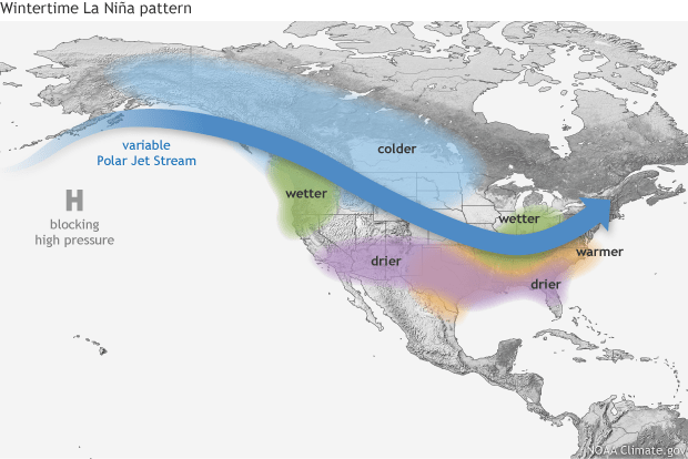
This pattern of a large ridge over the Pacific and a southward dip in the jet stream across the eastern half of the United States is also typical of La Niña phase of the El Niño-Southern Oscillation. La Niña is when the water temperatures in the east equatorial Pacific Ocean are colder than normal. This affects the typical location of the jet stream across the northern Pacific and North America. A wintertime La Niña pattern in North America looks like this (graphic from NOAA):
So the polar vortex isn't something that's unprecedented or caused by "climate change" or global warming. Many major cold outbreaks in the past have been associated with a southward dip of the polar vortex, such as 1977, 1982, 1985, 1989, and 2014. There is no cause to be alarmed when you hear about the polar vortex, but you should be prepared for colder temperatures. Bundle up and stay warm.


