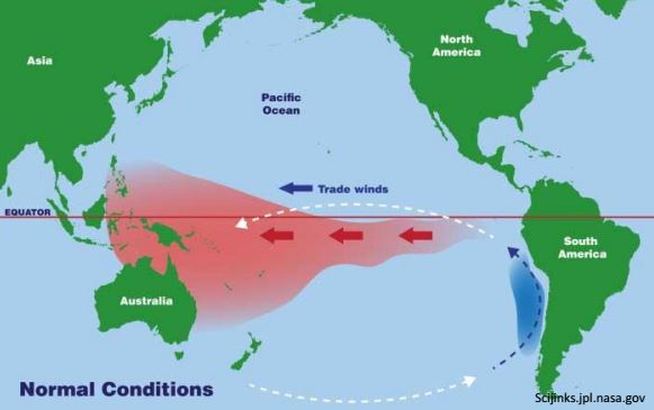
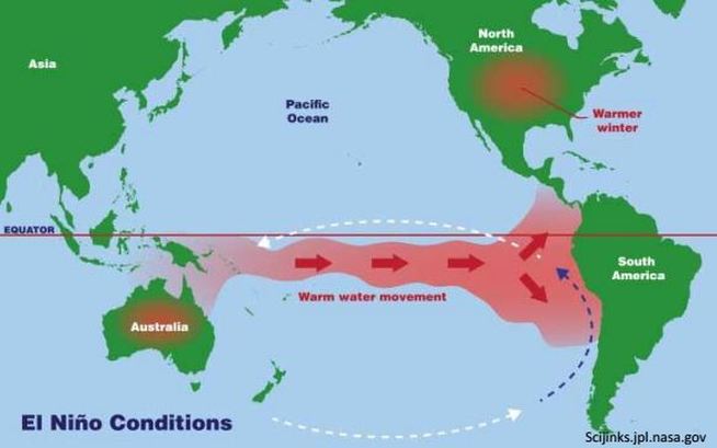
El Niño is a phase of what is called the El Niño-Southern Oscillation (ENSO) cycle. The ENSO cycle describes the fluctuations in temperatures between the ocean and atmosphere in the east-central Pacific near the equator. The other part of the ENSO phase is called La Niña.
The fluctuations in temperature are due to the strength of the trade winds in the equatorial Pacific. The trade winds usually move from east to west, which pushes the warm sea surface water to the west. As the water moves away from the South American coast, deep, cooler water rises to the surface to replace the displaced warm water.
The name El Niño is Spanish for "the boy", but refers to the Christ child because its effects near the South American coast are often most noticeable around Christmas. The water near the coast during El Niño tends to be nutrient-poor, which can have an impact to local fishing.
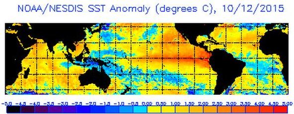
The image below shows what El Niño looks like using a satellite that detects sea surface temperatures. It shows the departure of the water temperature from normal, and you can see the abnormally warm water (orange and red areas) along the equator and near the northwest coast of South America.
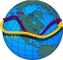
As the position of the warm water along the equator shifts across the Pacific Ocean, the position where the greatest evaporation of water into the atmosphere also shifts with it. This has a profound effect on the typical position of the jet stream across the Pacific Ocean.
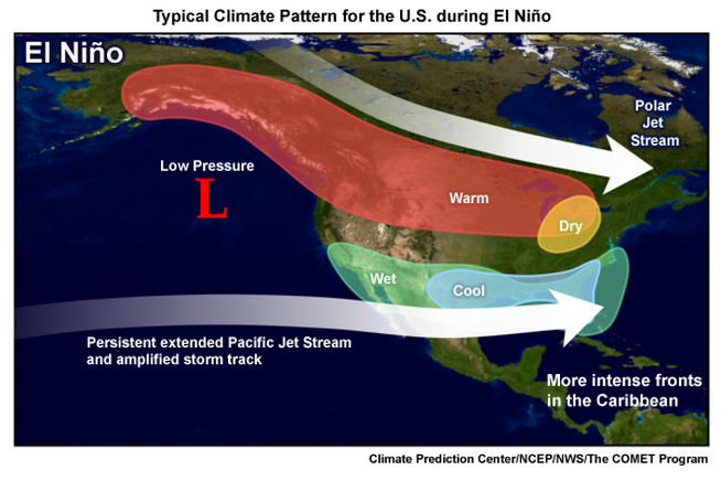
The jet stream is a band of strong winds in the upper levels of the atmosphere that impacts the formation of weather systems. El Niño tends to extend the jet stream farther east and position it farther south than normal. This results in a shift of the typical storm track from the northern to the southern part of the U.S. It also tends to result in more low pressure systems forming west of California.
The change in the typical tracks of storms can cause increased precipitation across California and the southern U.S. Northern states tend to have warmer and drier winters during an El Niño event, due to the polar jet stream shifting farther north, which brings less cold air southward. These effects tend to be strongest across North America during the winter.
But there are other effects in the atmosphere that will influence the weather across the U.S. this winter, and this makes it difficult to say that this winter's weather will be similar to 1997-98. We can only make general statements about what could happen, such as the chance of above normal rainfall in Southern California is higher, or that the northern parts of the U.S. is more likely to have above normal temperatures. El Niño can tilt the odds of a certain type of weather one way or the other, but there is not a clear connection between El Niño strength and weather impacts.
So dire warnings of a monster, deadly, destructive El Niño are extremely misplaced. The best approach is to keep watching the weather forecasts and take any warnings from the National Weather Service seriously. There's no need to panic about this guy:


