As the front moves out of the region on Saturday, high pressure will build in, bringing more stable conditions during the day. Winds from the Northwest will result in slightly cooler temperatures for the morning low, but with drier air aloft creating clearer conditions, afternoon temperatures should reach higher than on Friday. A few stray isolated showers are possible during the morning, however no significant rainfall is expected. Dry conditions will continue into Sunday, which will see the warmest highs of the weekend.
By: Stephen McCoy 
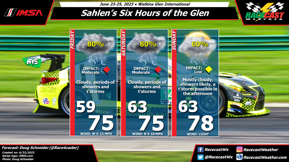
A cold front will move through the region late on Friday as a low pressure system tracks eastward over southern Ontario. The front will bring cloudy conditions through the day with a likely chance for showers, especially in the afternoon. Some thunderstorms may also develop along the front, which may cause a halt in track activities if lightning gets too close. However, for now, it is still too uncertain where individual storms will track. Winds through the day will largely be from the South, with some stronger gusts reaching to 20 MPH.
As the front moves out of the region on Saturday, high pressure will build in, bringing more stable conditions during the day. Winds from the Northwest will result in slightly cooler temperatures for the morning low, but with drier air aloft creating clearer conditions, afternoon temperatures should reach higher than on Friday. A few stray isolated showers are possible during the morning, however no significant rainfall is expected. Dry conditions will continue into Sunday, which will see the warmest highs of the weekend. By: Stephen McCoy Conditions have remained mostly consistent from the initial forecast from Monday. A front moving through the region on Thursday will bring cooler temperatures on Friday morning, though partly cloudy skies will allow afternoon temperatures to somewhat normalize. A second front is expected to move through late Saturday or Sunday, bringing cloudier conditions and a chance for showers. While we would normally expect warmer conditions with southerly winds ahead of the front, the potentially widespread rainfall will likely keep afternoon temperatures cooler than Friday. A few thunderstorms may be possible in the region during the afternoon, which would certainly halt any on-track sessions should lightning get too close. Some remaining showers will possibly move through overnight into Sunday, when clearer and warmer conditions will move in.
By: Stephen McCoy Before the weekend, there will be a cold front moving through the region on Thursday, associated with a low pressure system located over Northern Canada. Conditions behind the front will be as-expected for this type of synoptic setup: winds will shift to the West/Northwest, flowing around the center of the surface low. This will cause a slight dip in temperatures overnight Thursday into Friday, but afternoon temperatures should return to near 80°F (mid/upper 20's °C). With cooler, drier conditions aloft moving in from Northern Canada, expect clear to partly cloudy skies for much of Friday.
Saturday will provide differing conditions to Friday as another front is expected to make its way through the region in the evening to overnight. Surface winds will shift to the South ahead of the front, with Southwest winds aloft providing enough moisture to keep conditions mostly cloudy to overcast through the day. As fronts are generally weaker this time of year, temperatures will stay mostly constant between Friday and Saturday. There will most likely be some development along the front, creating a chance for scattered showers, especially during the afternoon, with some stronger thunderstorms possible in the region. Much like Friday, conditions for Sunday are fairly typical for this type of synoptic setup. While there is a slight chance for showers continuing overnight into Sunday morning, daytime conditions are expected to be dry. Surface winds may pick up after the front moves through as an area of high pressure begins to move in. By Doug Schneider Not much has changed in the forecast for IMSA's visit to CTMP this weekend. A few showers are possible Friday morning, and again on Sunday, but overall I expect the conditions to be good.
A cold front will move through southern Ontario Thursday night or early Friday morning. Expect a wet track as activities begin on Friday morning, but most of the rain should be gone by the time the first practice session begins at 9:15 am. The rest of the day will have clouds clearing out, with partly to mostly sunny skies. Saturday looks great, with pleasant temperatures and mostly sunny skies. Sunday is still a bit uncertain, as one model is showing some light rain through the day, but other models show dry conditions. There is an upper level trough that will be approaching from the west, which will bring moist air northward into southern Ontario. However, most of the rain should stay south of Lake Ontario. I expect that if there is any rain, there would only be a little sprinkle now and then, and it would have very little impact on the race. I don't expect that it would cause any delays or interruptions, though it may wet the track slightly. If you're going to the track, it might be a good idea to bring some rain gear, just in case. By Doug Schneider The weather looks favorable for IMSA's weekend at CTMP, but there are some uncertainties to this forecast that may impact the event.
A cold front is expected to cross the area sometime between late Thursday through Friday morning. Model difference in the timing makes it uncertain, but I think the most likely timing will take showers out of the CTMP area before on-track activities begin Friday morning. It will be breezy through the day as wind shift to the northwest, and sustained winds will be between 10 and 20 mph with gusts up to 30 mph possible. Saturday should be a very nice day, with mostly sunny skies and mild temperatures, thanks to high pressure building in that will supply dry air. Sunday is still uncertain, but I'm keeping it dry for now. Most models do the same with rain moving in on Monday, but a couple show showers spreading into the area through the day on Sunday. I will take the optimistic route on this one and keep Sunday dry, with the caveat that it could change with updated forecasts later in the week. By: Stephen McCoy Expected conditions are far from improved for Mid-Ohio this weekend. Temperatures, winds, and cloud cover remain mostly consistent with the initial forecast, however rainfall chances and impacts have increased significantly for the latter portion of the weekend.
Friday's synoptic pattern is still likely to occur as was suggested in the initial forecast from Tuesday. A low pressure system will be centered over Ontario to the north of the region, with a surface high located over the southeastern US. The anticyclonic motion around the high will bring moisture from the Gulf of Mexico north through the Great Plains and into the Midwest. The additional moisture will result in dew point temperatures hovering in the low 70's. Air temperatures in the mid 80's with mean heat index values will approach the low 90's for a high. Moisture in the low levels will bring cloudier conditions to the region, especially for the afternoon and may result in a few scattered showers in the area. Temperatures will cool slightly for the remainder of the weekend as cloudier conditions move in. Saturday and Sunday will see medium to high impacts for on-track sessions as showers and thunderstorms are likely during the afternoons. Each day could see upwards of 1/2" of rainfall, but the main safety concern will be lightning within the storms. By: Stephen McCoy The weather setup for this weekend's races at Mid-Ohio are not looking too favorable in the initial forecast. Mostly cloudy for the better portion of the event with chances for rainfall each day. Couple that with high dew point temperatures will make for muggy conditions for at least part of the weekend.
Entering the weekend, the mid Ohio region will be located between two major synoptic systems. A low pressure system is expected to be centered over Ontario, Canada with an area of high pressure located over the Southeastern United States. The anticyclonic rotation around the high will wrap moisture from the Gulf of Mexico through the southern Great Plains and into the Midwest, where the steering flow will be partially influenced by both pressure systems. A similar pattern will extend into the mid and upper levels of the atmosphere, resulting in plenty of cloud cover over the region. For Friday, conditions will start mostly cloudy with a chance for showers as a surface trough approaches the region from the West, extending from the low pressure system over Ontario. Conditions will begin to clear for the late morning and early afternoon, which will cause temperatures to warm into the mid 80's for a high. The added moisture to the region will mean dew point temperatures will reach the mid 70's, resulting in heat index values in the mid 90's for the afternoon. Cloud cover will increase during the afternoon and evening as scattered thunderstorms may develop. The aforementioned synoptic pattern is expected to continue into Saturday, resulting in mostly cloudy conditions through the day with heat index values in the low 90's. Scattered thunderstorms are possible again in the afternoon, which may have major impacts for the on-track sessions. Similar conditions may be present on Sunday, but with slightly cooler temperatures as winds shift to the West. By Doug Schneider The forecast for Watkins Glen continues to look very wet this weekend. A low pressure system that has brought a lot of rain to the Southeast over the last few days will continue to track slowly northeast. The counter-clockwise flow around this low will draw a lot of moisture off the Atlantic Ocean into upstate New York, causing periods of showers and thunderstorms at the track on Friday and Saturday. The northeast movement of the low will take it east of the Finger Lakes region on Sunday, which will lower the chance of rain and allow for some partial sunshine, but I expect that afternoon instability will cause scattered showers to develop in the area. The uncertainty in this forecast is how much rain will fall. There is a potential for heavy rainfall at times, especially Friday and Saturday. This could cause delays to the on-track activity, as well as localized flooding. Campers should avoid setting up tents in low lying areas which may be prone to flooding. Lightning will also be an issue to stay aware of - make sure you have a place to find shelter when thunder is heard, like inside a car or a building. The National Weather Service Weather Prediction Center forecast rain amounts are around 0.25 to 0.5 inches on Friday, 0.5 to 0.75 inches on Saturday, and 0.1 to 0.25 inches on Sunday. So the range of possible amounts for the event is expected to be between 0.8 and 1.5 inches total. Here's their graphic of rain amounts for Friday through Sunday. Follow @RacecastWx on Twitter, as I'll try to post regular radar updates through the event. If you're at the track, please tag us in your photos.
|
Social Feeds
Authors
Doug Schneider Partners
Categories
All
Archives
December 2023
|