
By: Stephen McCoy - @stephenmmcc
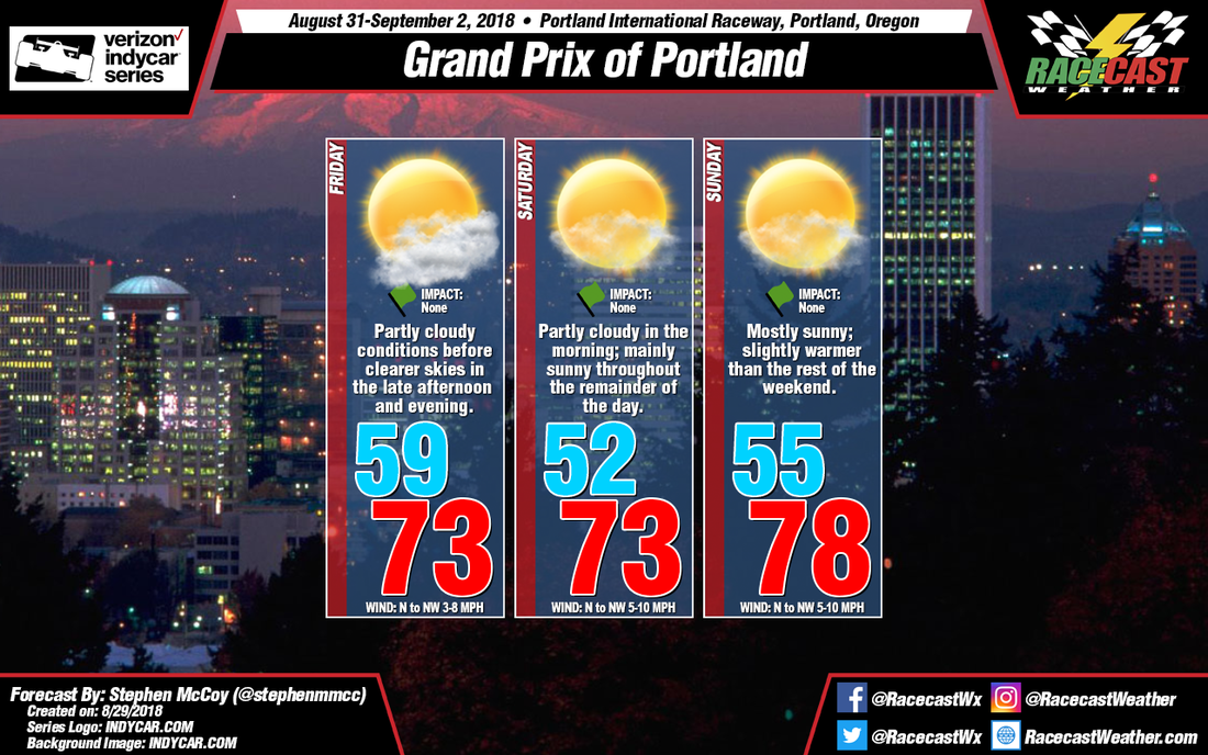
Plenty of sunshine and comfortable temperatures remain in the forecast for Indycar's return to Portland International Raceway for the Grand Prix of Portland.
On Friday, the backside of an upper level longwave trough will be over the Pacific northwest, causing winds to carry dry air to the region from the northwest from western Canada and Alaska. Winds in the low to mid levels of the atmosphere are expected out of the west to northwest, bringing slightly more moist air from the Pacific ocean to northwestern Oregon. With dry air aloft and slightly moist air in the mid to low levels, partly cloudy conditions are likely for Friday, with cloud cover decreasing into the evening hours. Surface winds from the north to northwest will keep conditions relatively cool and dry with high temperatures reaching the low to mid 70's. With dew point temperatures around 50 degrees, the apparent temperature will be about equal to the actual temperature.
Similar conditions are expected for Saturday, though with drier air moving into the region in the low levels, mostly sunny conditions are expected with some light cloud cover possible, mostly concentrated in the lower levels. Winds at the surface will remain from the north to northwest around 5-10mph, but with the addition of low level winds also from the north to northwest, there is a potential for gusts around 12-15mph.
On Sunday, the jet stream in the mid and upper levels will be located over Washington and southern Canada and will continue to bring dry air to the region. Mostly sunny conditions will be likely as, in addition to the upper and mid levels, dry air is likely to move into the region at the low levels from the north to northwest. With little cloud cover, daytime heating will warm the surface, with temperatures likely reaching the mid to upper 70's. Again, with low dew point temperatures, apparent temperatures will likely be equal to the air temperatures.


