Check back later in the week for updates.
By Doug Schneider 
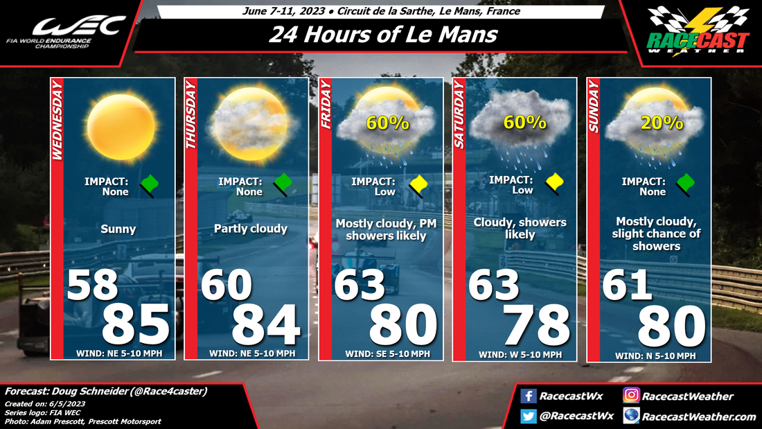
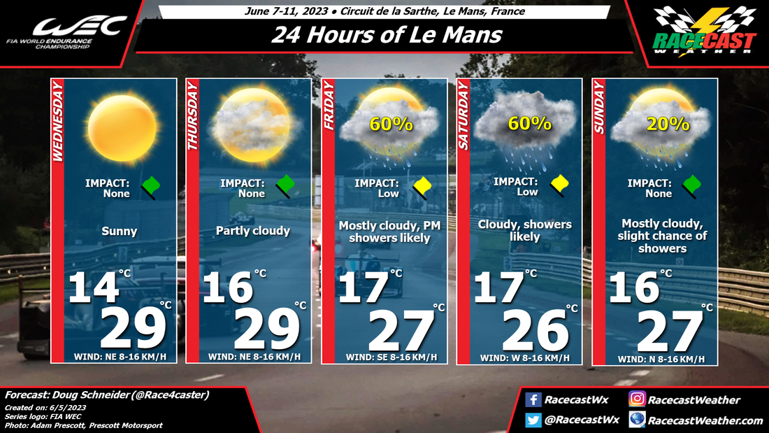
The pattern across western Europe during the second half of the week will have high pressure over England and the North Sea, with a low pressure system in the eastern Atlantic, off the Iberian Peninsula. As Le Mans practice sessions begin, the weather will be sunny and warm on Wednesday and Thursday, thanks to the high pressure system being dominant. Through the weekend, this pattern will shift slowly east, so that the high loses its grip and the low pressure system spreads moisture into France. Showers are likely to arrive at Le Mans during the afternoon and evening hours on Friday. Showers will continue to be in the area through Saturday. The good news is that this does not look like a very heavy rain. I expect that it will be light enough to allow for the on-track sessions to be held, for the most part. Interruptions should be minimal, but wet tires will likely be needed. On Sunday, there is just a small chance of showers, and I expect that the second half of the race will mostly be dry.
Check back later in the week for updates. By: Stephen McCoy The updated forecast for Laguna Seca has temperatures a few degrees warmer than the initial forecast with clearer conditions towards the end of the weekend.
The synoptic setup for the latter portion of this week remains similar, however the surface trough mentioned in the previous forecast is now expected to be located a bit further east, approaching the region closer to Sunday. A weaker pressure gradient will result in less cold air advection to the Monterey Bay area. In addition, what was rightfully pointed out, WeatherTech Raceway Laguna Seca is actually a few miles further inland than the city of Monterey so the cooling effect from the bay winds will not be as powerful at the track as directly on the coast. However, even being a few miles away, there is still a possibility for fog during Saturday and Sunday mornings, which will clear into the afternoons; partly cloudy conditions may continue in the low levels. By: Stephen McCoy Conditions in Monterey should be fairly similar to those in the previous IMSA race at Long Beach. Temperatures will be in the low-to-mid 60s with partly cloudy skies and some fog possible during the mornings.
On the synoptic scale, a low pressure surface trough is expected to extend along the California coastline, and remain mostly stationary through the weekend. The alignment of the trough will result in surface winds mainly from the northwest throughout much the forecast period; normally we would see a land-sea interaction where winds would flip between the day and night. The moist air off the Pacific Ocean will enter the Monterey Bay area, condensing as it encounters the trough, which will result in partly cloudy conditions in the low-to-mid levels. As the temperatures get cooler in the mornings, this may also lead to some localized areas of fog which have a chance to last into the late morning. Temperatures will be near normal for this time of year, though the strength and direction of the surface winds may swing the highs by a few degrees, especially for Saturday and Sunday. For Sunday, cloud cover may be largely in the upper levels due to a cutoff upper level trough located near to the region. We'll see cloudier conditions the further west the trough is, however if the low ends up more to the east, clearer conditions will be more likely. By: Stephen McCoy There will be some slightly below-average temperatures for this weekend at Long Beach, however the remaining conditions are to be expected for this time of year in SoCal. We'll see a typical sand-sea interaction each day where winds will move off the land over the Pacific overnight and through the morning before reversing, with afternoon conditions consisting of winds coming onshore. As a result of this interaction, there is a possibility for patchy to widespread fog in the morning after sunrise, but should clear fairly quickly by the late morning and should not last into the afternoon. Skies are expected to start the weekend partly to mostly cloudy in the lower levels of the atmosphere, but should clear out Friday afternoon. Clearer conditions will persist through Saturday, before upper level cloud cover moves in for Sunday.
By Doug Schneider Click the forecast images to enlarge Good news with today's forecast update - the cold front that will be approaching Sebring is trending slower, which means a later arrival of showers. A later arrival time closer to sunset means there will be less instability for storms to tap into, so strong storms are unlikely. The coverage of showers is also looking less than it was before, so the chance of shower during the race is lowering.
There are still some timing differences among the models, but I expect that the window for showers and thunderstorms to arrive will be between 7 pm and 10 pm - the last few hours of the race. There is still a potential for a lightning delay, depending on whether a storm tracks close enough to the track, but the risk appears lower than with previous forecasts. The threat of strong wind gusts and heavy rain has also decreased, but again, the threat will depend on whether a storm moves directly over the track. With coverage expected to be scattered, they could miss the track completely. I'll try my best to post radar updates during the race on our Twitter account - @RacecastWx. By Doug Schneider Click on the forecast images to enlarge Not much has changed with the expected weather pattern at Sebring this weekend. Thursday and Friday continue to look great, with plenty of sunshine and warm temperatures each afternoon.
Saturday continues to be a concern for impactful weather at the track. A cold front approaching from the north will interact with a warm and unstable air mass across the Florida Peninsula, leading to showers and thunderstorms in the area during the afternoon. Timing continues to be very uncertain, as the arrival time of rain is different in the models by several hours. The earliest arrival time looks to be between noon and 2 pm. However, I think the most likely time for showers to begin at the track will be between 2 pm and 5 pm. There could be multiple rounds of showers, so I expect that rain and possibly some thunderstorms could remain around the area into the evening hours. The main impact with these storms will be lightning. It will be important for fans to have a place to seek shelter when thunder is heard. I expect that lightning will result in a stoppage of the race at some point for the safety of the corner marshals and the cameramen on towers. Another possible impact will be winds, which could become gusty when the storms move in, so campers will need to secure loose objects, especially tents and canopies. Finally, a brief heavy downpour will be possible. I expect the total rainfall amount through the end of the race to be between a quarter and a half inch, but it could come down quite heavily at times. By Doug Schneider Click on the forecast images to enlarge All eyes will be on the Saturday's weather for this year's edition of the 12 Hours of Sebring. The forecast graphics tell the story about Wednesday through Friday - beautiful weather is expected those days, with no impacts, so I'll focus on Saturday.
A cold front is expected to approach the area on Saturday, and cross Sebring late Saturday night. Rain is likely ahead of the front, in the form of numerous showers and thunderstorms. The primary hazard with these storms will be lightning. I expect that there will be delays during the race due to lightning in the area. Other potential impacts from storms will be heavy downpours and gusty winds. Fans at the track should be prepared for rainy and windy conditions, and have a plan to seek shelter when lightning is in the area. The uncertainty with these impacts is when they will happen. There will be a warm and unstable air mass ahead of the approaching cold front across southern and central Florida, so thunderstorms could pop up early in the afternoon. However, it looks like the models are showing the bulk of rain occurring in the late afternoon and evening hours, during the second half of the race. The thunderstorm threat will linger into Saturday night for campers at the track, as the front isn't expected to move through the area until late in the night or early Sunday morning. Since we are still several days away, the exact timing remains unclear, but that should come into better focus later in the week. Check back here for updates. By Doug Schneider The weather continues to look great for this year's edition of the Rolex 24 Hours at Daytona. Only a few small changes were made from Monday's initial forecast.
Today at Daytona will be warm and breezy. High temperatures will reach the mid 80s, and winds will be 10 to 20 mph, with gusts of 25 to 30 mph at times. A cold front will approach the area from the northwest, and bring some showers to the area tonight. Colder temperatures will follow the cold front for Thursday, with high temperatures about 15 to 20 degrees colder than Wednesday. Cool and sunny conditions will continue through Saturday as winds remain from the north. Sunday will see warming temperatures into the 70s, with increasing clouds. Some rain showers could arrive late Sunday, but it looks like they will hold off until after the race is over. |
Social Feeds
Authors
Doug Schneider Partners
Categories
All
Archives
December 2023
|