
Race time is getting closer, and we are starting to get a better look at the weather details for the weekend. Looks like for now, Saturday will be the only day you will need an umbrella.
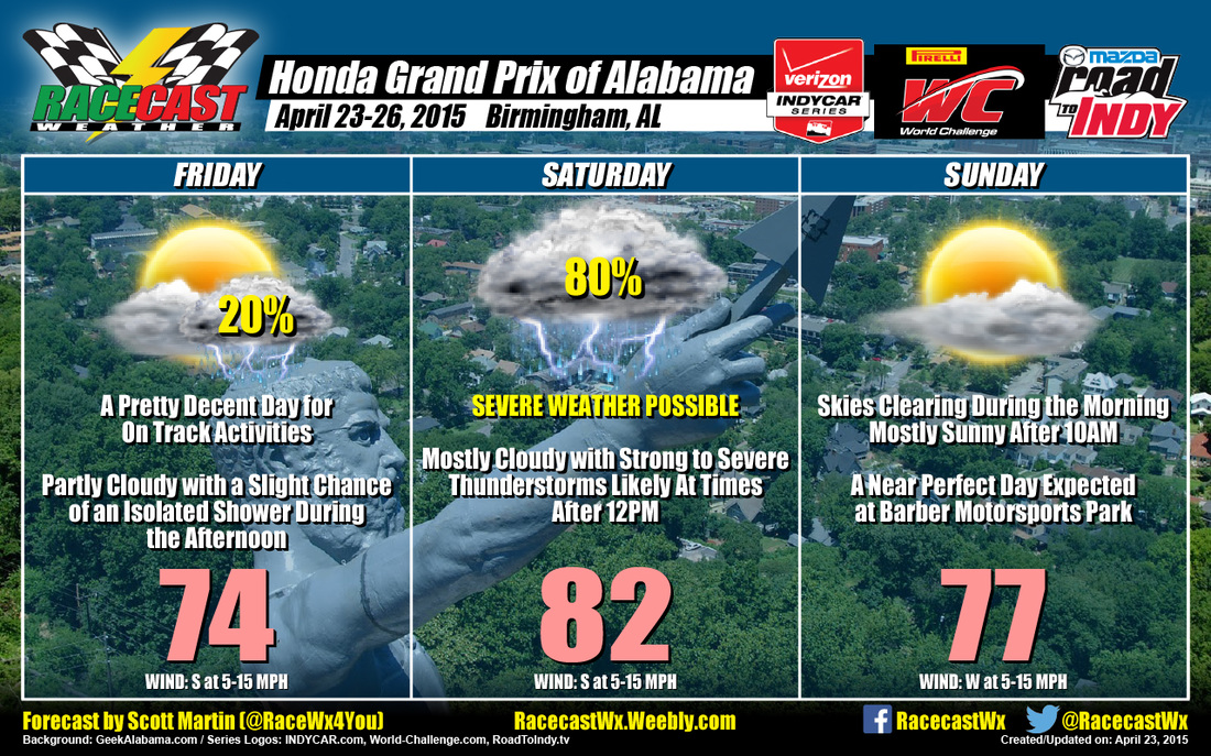
FRIDAY
Looks like the day might actually be a pretty decent day after all. Latest model trends are showing temps in the lower 70s with partly cloudy skies. There may be an isolated shower that pops up during the afternoon as the warm front starts to make its way north through the state, but I highly doubt it. I'll still keep the chance of rain at 20%, just to be on the safe side. The main action doesn't start to move in until the overnight hours.
SATURDAY
To start off, the Storm Prediction Center in Norman, Oklahoma, has the whole state under a slight risk for severe weather throughout the whole day. There will actually be two separate severe weather threats for the area. One will be moving through sometime between 2:00AM - 4:00AM. The main threat from these early storms will probably be damaging straight line winds and small hail. After those move through, there will be a good part of the day that will be dry and sunny at times. Unfortunately sunny conditions in this environmental setup is not a good thing. Daytime heating will allow for the atmosphere to get unstable, as highs are now expected to reach the lower to middle 80s. Cells could fire up at anytime during the afternoon and evening hours and may become severe quickly. Models are showing a trend of higher instability during the afternoon, especially surface based CAPE and wind shear values. All modes of severe weather is possible: damaging straight line winds, damaging hail, and a few isolated tornadoes are not out of the question. I'm thinking that rain is almost a certain bet, but I'll say the chance of rain is 80%. The best thing to do is not be scared of the weather, but have a source of weather information close by. Both Doug and I will be at Barber and will be tweeting any information concerning the weather. If you're at the track, be sure to find a shelter area before you find a place to sit and enjoy the races.
SUNDAY
Once the action moves out during the late night hours, the day is going to be fantastic. Skies will be mostly clear and temps will be in the upper 70s. Should be a great day for racing, just as long as someone doesn't slide off the track in the grass.
Our radar link is http://RacecastWx.Weebly.com/radar. It will have the latest up-to-date radar image, along with any severe weather warnings that are issued. Once again, I hope that this forecast is a bust and there is no threat during Saturday afternoon. There is one possibility. If the action during the early morning hours on Saturday work over the atmosphere enough, it may not recover enough to produce severe weather in the afternoon. Lets keep our fingers crossed.


