
By Scott Martin
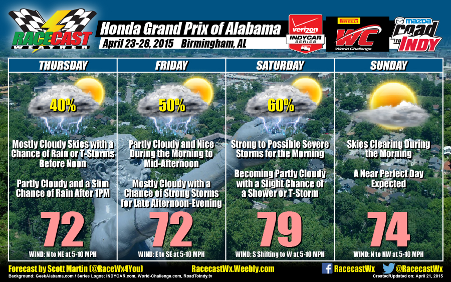
THURSDAY
A frontal boundary approaches the area on late Wednesday night through Thursday as an upper level impulse moves eastward over the southeastern states. This will cause a chance of precipitation to increase for the morning till about noon on Thursday. I can’t rule out a stray shower after that, but chances are slim. Highs will be in the lower 70s. Chance of rain is 40%. Winds out of the N to NE at 5-10 MPH.
FRIDAY
Day should start off partly cloudy and dry for the early morning time. A surface low develops and moves into the Mississippi Valley, causing the frontal boundary to move back to the north as a warm front. As that happens, a low level jet will develop to the west of the area. This should set up an increase in showers and thunderstorms for the afternoon through the evening and overnight hours. Highs will reach the lower 70s. Chance of rain is 50%. Winds out of the E to SE at 5-10 MPH.
SATURDAY
As the surface low will still be to the north and west of the area, rain and thunderstorm chances are still in the forecast for Saturday morning. Some of these storms could be strong to severe, and instability values are starting to show on models. Surface CAPE is showing values over 2000 j/kg. Still too early to determine what types of severe, if any. I believe the stronger stuff moves out during the afternoon and we will be left with partly to mostly cloudy skies with a slight chance of a lingering shower or thunderstorm. Highs will top out in the upper 70s. Chance of rain is 60%. Winds out of the S shifting to W at 5-10 MPH.
SUNDAY
Skies clear out as the surface low moves away for Sunday. Expecting mostly sunny skies and near perfect temperatures for late April in Alabama. Highs make the middle 70s. No chance of rain. Winds out of the N to NW at 5-10 MPH.
For updates to the forecast through the week, follow our Facebook page and Twitter accounts (@Race4caster and @RacecastWx). We will both be at Barber this weekend, and we would love to meet you.


