
By Doug Schneider (@Race4caster)
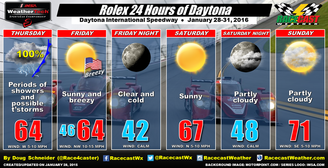
Yesterday saw 2.31 inches of rain fall at the Daytona airport right beside the Speedway from 2 am through 1 pm. Fortunately, there was only some very light rain around through the afternoon (only a trace was recorded from 1 pm to 8 pm), and the Continental Tire practice sessions were relatively undisturbed. So while my forecast of 100% chance of rain verified, it was timed just right to have a minimal impact on the on-track activity. Temperatures yesterday stayed cool, with the high only reaching 65 degrees, due to a front that remained just south of Daytona all day (and ruining my temperature forecast).
That front is sitting pretty much right over Daytona this morning. Most of the rain is well to the south early this morning, but that will change later this morning. A low pressure center will ride northeast along that front, and cross central Florida from late morning through mid afternoon. That appears to be the timing for the best rain chances and heaviest rain amounts at the track today. Some pockets of heavy rain and a few thunderstorms will be possible. The CTSC and IWSC practice sessions will be threatened, but that will depend on the timing of the heavier showers or storms. CTSC qualifying at 2:10 pm looks very wet as well. The amount of rainfall through the day is expected to be between 0.5 and 1 inch, but again, it will vary greatly based on where the heavier showers track.
Will rain threaten the IWSC qualifying at 4:25 pm? It's going to be close. Here's a model simulated radar image at 4 pm this afternoon (Daytona is near the red dot):
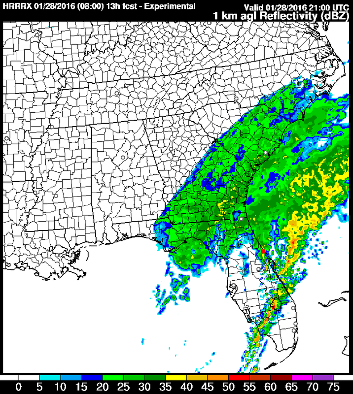
I wouldn't take that model simulated radar as the absolute truth, but it does tell me that the rain will likely be tapering off around the time that qualifying begins, perhaps in a window between 3 pm and 5 pm. There are some other models that show similar timing to this one. Yesterday, I mentioned how one model (the NAM) was much slower to end the rain. Fortunately, it has straightened up and come into better agreement with the rest of the models.
There are no big changes to the forecast for Friday, Saturday, and Sunday as the weather continues to look dry and cool. Bring a jacket on Friday, as it will be breezy with a northwest wind blowing 10 to 15 mph, and highs will be in the mid 60s. Race day will start off cold in the lower 40s, but with plenty of sunshine, highs will reach the upper 60s. The entire race continues to look dry, and by the end of the race, temperatures will be near 70 degrees.
Our live radar link at the top of the page will be continuously updating all day to help you keep track of the rain today. It will also display any lightning strikes that may occur. I'll most likely be watching qualifying along with the radar, and I'll do my best to have weather updates on Twitter this afternoon - follow @Race4caster.


