By Doug Schneider 
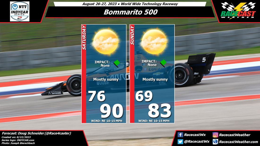
It's going to be a hot week in the St. Louis area, but the good news is that cooler temperatures will arrive in time for the Bommarito 500 activities. High temperatures at WWTR on Thursday and Friday will be near or above 100 degrees. On Saturday morning, a front is expected to move through the area, which will shift winds to the northeast and bring a cooler and less humid air mass. With moisture being very limited, no rain is expected with the front at this time, but this will need to be monitored for changes through the week. Sunday will be a very nice day to be at the track, with highs in the lower 80s and comfortable humidity levels. There will be a northeast breeze both days, between 10 and 15 mph.
By Doug Schneider There will be a few rounds of showers in Indianapolis over the weekend, but the timing of these showers looks favorable for little to no impacts on the racing at IMS.
An upper level disturbance will be crossing the Illinois/Indiana area Friday night, and thunderstorms are likely to occur during the overnight hours. There is a small chance that some showers could linger around Speedway after sunrise, but they should be gone by the time of the first on-track session (Xfinity practice) at 9:35 am EDT. The rest of Saturday should be dry and mostly sunny, with temperatures reaching into the mid 80s. There could be a few showers in the area Saturday evening as a front moves into the area, after the end of the Xfinity Pennzoil 150. Another upper level disturbance will cross the Mississippi River on Sunday, and track east through the afternoon. Showers with this system are expected to move into central Indiana late in the day or during the evening, most likely after the end of the Verizon 200. If the timing of this system shifts a little earlier, it could impact the late stages of the race, but I think the chance of that happening is low. By Doug Schneider Overall, good weather is expected at IMS for the combined INDYCAR and NASCAR events for Brickyard Weekend. The main risk of rain at the track will come on Friday night as an upper level trough swings across the area. The most likely timing of this rain should not affect any on-track action, however a few showers will be possible into Saturday morning. The chance of rain should be gone by the time the INDYCAR race starts at 2 PM. Sunday's weather looks great for the NASCAR race, with mostly sunny skies. Temperatures through the weekend will peak in the mid to upper 80s.
By Doug Schneider The forecast continues to look great for racing this weekend at Iowa Speedway. I don't expect any weather impacts to the on-track action. However, there could potentially be some impacts to the concert on Saturday.
The prevailing weather pattern across Iowa will be a northwest flow through the weekend. This will provide mainly dry and comfortable temperatures and humidity. However, the models are indicating that a disturbance in this northwest flow will move across Iowa late Saturday into Saturday night. It may bring isolated to scattered thunderstorms to the area late in the afternoon and evening. While the timing won't affect the race, the Kenny Chesney concert that starts at 4:30 pm could potentially be affected, depending on the timing of storms. I don't know how long the concert will be, but right now, the most likely time period for storms is 6 pm to midnight. If that timing shifts a little earlier, then it could potentially affect the concert. By: Stephen McCoy Conditions have remained mostly consistent from the initial forecast from Monday. A front moving through the region on Thursday will bring cooler temperatures on Friday morning, though partly cloudy skies will allow afternoon temperatures to somewhat normalize. A second front is expected to move through late Saturday or Sunday, bringing cloudier conditions and a chance for showers. While we would normally expect warmer conditions with southerly winds ahead of the front, the potentially widespread rainfall will likely keep afternoon temperatures cooler than Friday. A few thunderstorms may be possible in the region during the afternoon, which would certainly halt any on-track sessions should lightning get too close. Some remaining showers will possibly move through overnight into Sunday, when clearer and warmer conditions will move in.
By: Stephen McCoy Before the weekend, there will be a cold front moving through the region on Thursday, associated with a low pressure system located over Northern Canada. Conditions behind the front will be as-expected for this type of synoptic setup: winds will shift to the West/Northwest, flowing around the center of the surface low. This will cause a slight dip in temperatures overnight Thursday into Friday, but afternoon temperatures should return to near 80°F (mid/upper 20's °C). With cooler, drier conditions aloft moving in from Northern Canada, expect clear to partly cloudy skies for much of Friday.
Saturday will provide differing conditions to Friday as another front is expected to make its way through the region in the evening to overnight. Surface winds will shift to the South ahead of the front, with Southwest winds aloft providing enough moisture to keep conditions mostly cloudy to overcast through the day. As fronts are generally weaker this time of year, temperatures will stay mostly constant between Friday and Saturday. There will most likely be some development along the front, creating a chance for scattered showers, especially during the afternoon, with some stronger thunderstorms possible in the region. Much like Friday, conditions for Sunday are fairly typical for this type of synoptic setup. While there is a slight chance for showers continuing overnight into Sunday morning, daytime conditions are expected to be dry. Surface winds may pick up after the front moves through as an area of high pressure begins to move in. By: Stephen McCoy Expected conditions are far from improved for Mid-Ohio this weekend. Temperatures, winds, and cloud cover remain mostly consistent with the initial forecast, however rainfall chances and impacts have increased significantly for the latter portion of the weekend.
Friday's synoptic pattern is still likely to occur as was suggested in the initial forecast from Tuesday. A low pressure system will be centered over Ontario to the north of the region, with a surface high located over the southeastern US. The anticyclonic motion around the high will bring moisture from the Gulf of Mexico north through the Great Plains and into the Midwest. The additional moisture will result in dew point temperatures hovering in the low 70's. Air temperatures in the mid 80's with mean heat index values will approach the low 90's for a high. Moisture in the low levels will bring cloudier conditions to the region, especially for the afternoon and may result in a few scattered showers in the area. Temperatures will cool slightly for the remainder of the weekend as cloudier conditions move in. Saturday and Sunday will see medium to high impacts for on-track sessions as showers and thunderstorms are likely during the afternoons. Each day could see upwards of 1/2" of rainfall, but the main safety concern will be lightning within the storms. By: Stephen McCoy The weather setup for this weekend's races at Mid-Ohio are not looking too favorable in the initial forecast. Mostly cloudy for the better portion of the event with chances for rainfall each day. Couple that with high dew point temperatures will make for muggy conditions for at least part of the weekend.
Entering the weekend, the mid Ohio region will be located between two major synoptic systems. A low pressure system is expected to be centered over Ontario, Canada with an area of high pressure located over the Southeastern United States. The anticyclonic rotation around the high will wrap moisture from the Gulf of Mexico through the southern Great Plains and into the Midwest, where the steering flow will be partially influenced by both pressure systems. A similar pattern will extend into the mid and upper levels of the atmosphere, resulting in plenty of cloud cover over the region. For Friday, conditions will start mostly cloudy with a chance for showers as a surface trough approaches the region from the West, extending from the low pressure system over Ontario. Conditions will begin to clear for the late morning and early afternoon, which will cause temperatures to warm into the mid 80's for a high. The added moisture to the region will mean dew point temperatures will reach the mid 70's, resulting in heat index values in the mid 90's for the afternoon. Cloud cover will increase during the afternoon and evening as scattered thunderstorms may develop. The aforementioned synoptic pattern is expected to continue into Saturday, resulting in mostly cloudy conditions through the day with heat index values in the low 90's. Scattered thunderstorms are possible again in the afternoon, which may have major impacts for the on-track sessions. Similar conditions may be present on Sunday, but with slightly cooler temperatures as winds shift to the West. |
Social Feeds
Authors
Doug Schneider Partners
Categories
All
Archives
December 2023
|