
By Doug Schneider
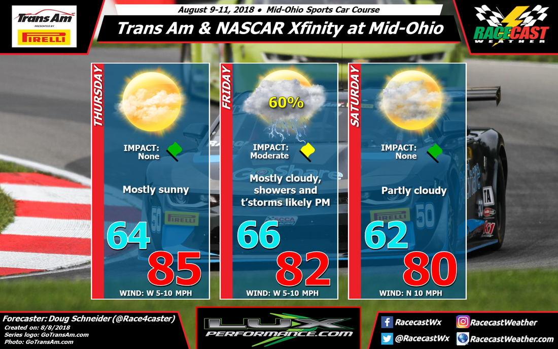
There's some good news and some bad news with the forecast update for racing at Mid-Ohio. The good news is that the chance of rain has dropped enough on Saturday that I took any mention of rain out of the forecast for that day. The bad news is that the chance of rain is looking better on Friday, up to a 60% chance.
A cold front and an upper level trough will be moving across the upper Great Lakes on Thursday. The arrival of any storms with this front in Ohio should be late enough on Thursday evening that it should not impact any of the activity on the track that day, so I'm keeping Thursday rain-free. There may be some storms that arrive in the Mid-Ohio area in the evening, possibly as early as 8 pm.
The front will still be in the Mid-Ohio area on Friday, and it will be the focus for numerous showers and thunderstorms to develop during the day. Coverage of showers in the morning will be scattered, with increasing coverage in the afternoon. So while there is a chance of rain at any time of the day, the afternoon hours will have the greatest chance of storms impacting the action. Rainfall amounts between a tenth and a quarter inch can be expected. Lightning will be a threat, so if you're at the track, have a plan before the storms arrive to find adequate shelter.
The models have some differences of where the front will be for Saturday, but the majority seem to indicate that it will be south of Mid-Ohio, with drier and more stable air building in on the heels of a northerly wind flow. One model, the NAM, holds the front back and produces some showers in the area Saturday morning. I think the most likely scenario is that the showers and storms develop south of the track, and thus I'm going with a rain-free forecast on Saturday. Hopefully that pans out and there will be at least one nice weather day for racing.


