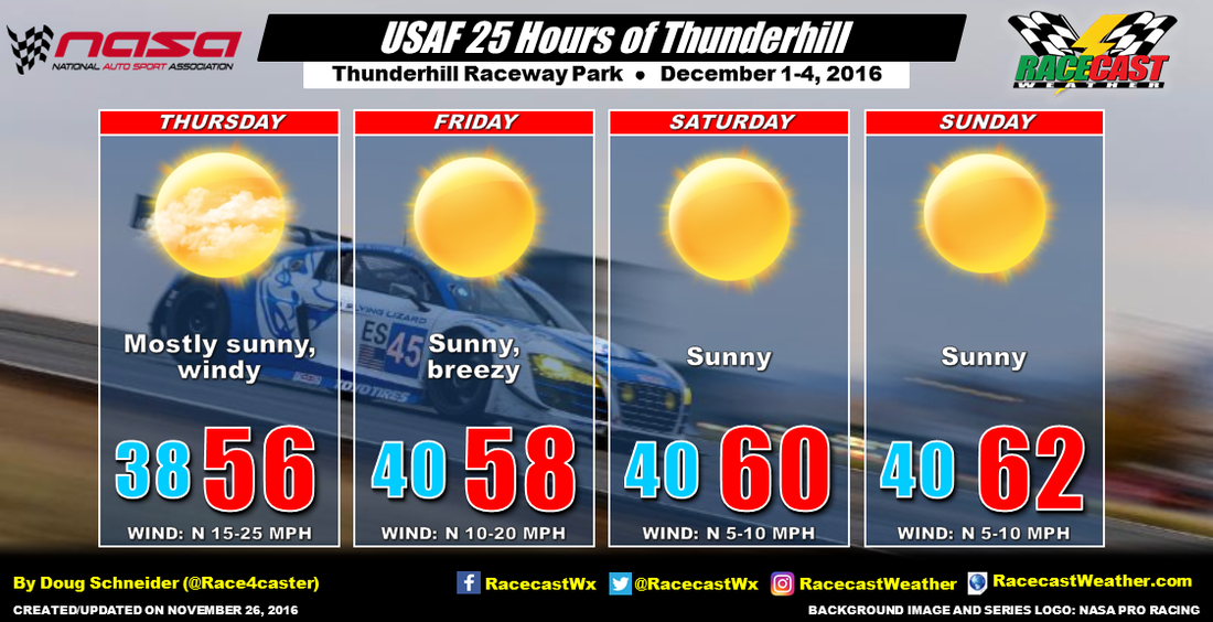
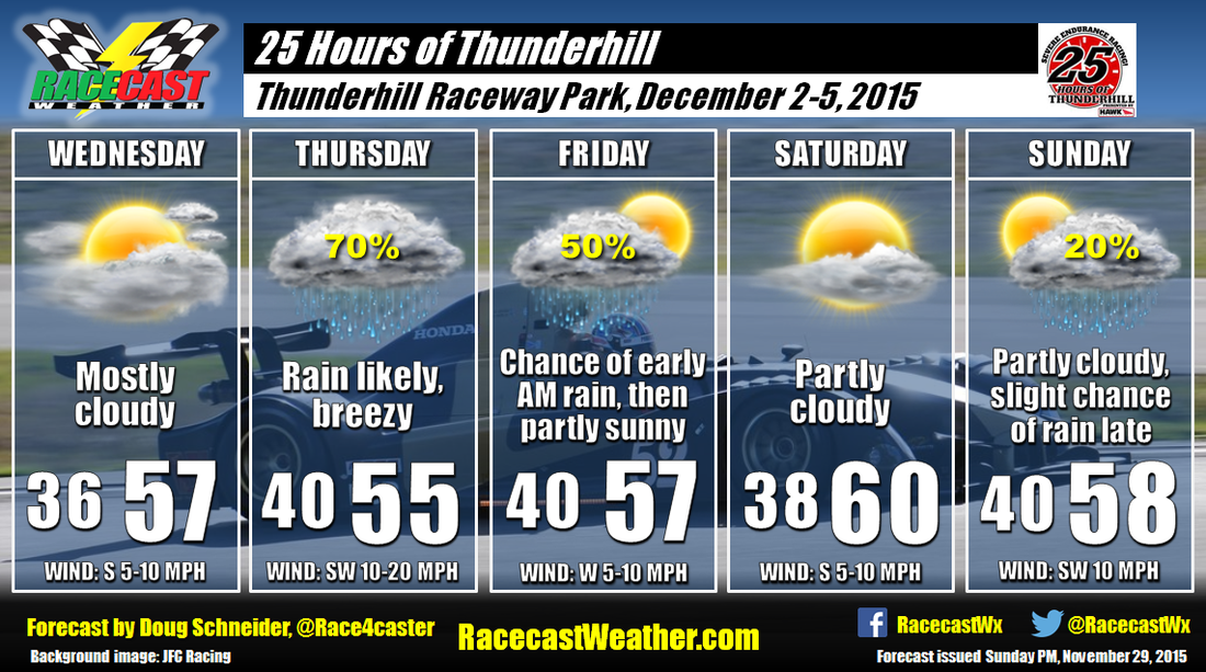
By Doug Schneider 
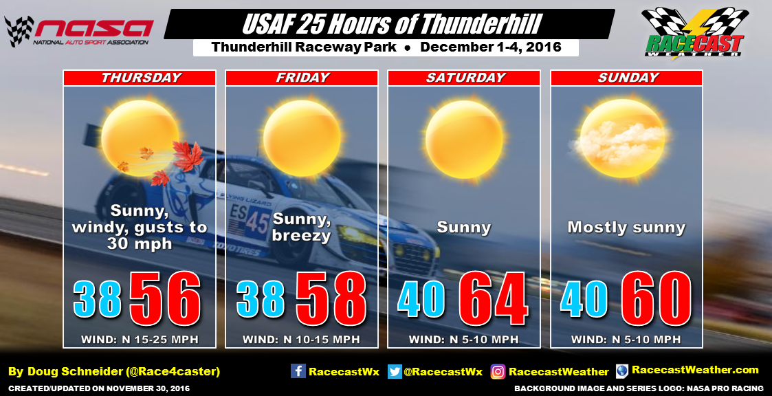
The weather continues to look great for the 25 Hours of Thunderhill. The only weather impact may be some windy conditions on Thursday for the testing sessions. Winds from the north will be sustained at 15 to 25 mph, and may gust to around 30 mph at times. It will still be breezy on Friday, but not as windy, with winds between 10 and 15 mph most of the day. Temperatures for the start of the race will be mild for Northern California this time of year, reaching the mid 60s by the afternoon. On Sunday, an upper level trough will be approaching, and it may bring a few more clouds. But any rain associated with it will not arrive until long after the race is over.
By Doug Schneider The final major sportscar race of 2016 is upon us. This year seems to have flown by for me. It's been a terrific year of racing in so many series, and Scott and I thank you for following our forecasts. We will be back again next year, continuing to combine our love for weather and racing here at Racecast Weather.
Simply put, the weather looks good for the USAF 25 Hours of Thunderhill. There will be a cold front that is expected to move across Northern California Wednesday night; however, no rain is expected at Thunderhill with the front. Any rain associated with the front should remain well to the north and east. Behind the front, it will become quite windy on Thursday, with a north wind at 15 to 25 mph bringing chilly temperatures in the 40s and 50s through the day. For the rest of the weekend, a large high pressure system will be over the east Pacific Ocean. It will provide dry weather and abundant sunshine at Thunderhill Raceway as it builds toward the east. Temperatures will gradually warm a little through the weekend, and highs on Saturday and Sunday afternoons will be around 60. Chilly temperatures in the 40s are expected Saturday night, with temperatures between 55 and 60 by the end of the race at noon on Sunday. By Doug Schneider It's looking more and more likely that there will be some rain for the second half of the 25 Hours of Thunderhill. Remember that trend of a faster system that I mentioned a few days ago? It it getting even faster as the rain is expected to arrive Saturday night.
The graphic above gives a general idea of what conditions you can expect through the race. It will start off partly cloudy, but the clouds will be increasing through the afternoon. By sunset (which is around 4:40 PM), clouds should be covering the sky and temperatures will fall into the 40s. The main weather feature that is bringing rain is a disturbance in the mid and upper levels of the atmosphere. Rain with the system is expected to start between 2 AM and 5 AM, and I'm confident that it will be raining before sunrise (which is around 7:20 AM). The period of heaviest rainfall is expected to be between 5 AM and 9 AM. Rain should start to decrease late Sunday morning, but there will likely still be some showers around the track through the end of the race, which is at noon. The total amount of rain expected during the race is between a tenth and a quarter inch. I'll do my best to have live weather updates through the race on my Twitter account (@Race4caster). You can always check the radar using the link at the top of the website. By Doug Schneider Testing this afternoon at Thunderhill is going to be wet, as rain will be spreading across northern California from the late morning through tonight. Expect rain to start at the track between 11 am and 1 pm. It could come down fairly heavy at times this afternoon. It will be breezy, with south winds of 10 to 20 mph, and gusts up to 30 mph possible. The rain will continue through tonight and early Friday morning. Most of the rain should be gone by sunrise, so I expect that Friday's testing will be rain-free, although the track may be wet in the morning. The total amount of rainfall at the track from today through Friday morning will likely be around a half inch.
Saturday's weather looks great, with plenty of sunshine. It will be chilly in the morning, with lows in the upper 30s, but highs will reach the upper 50s by the mid afternoon. Sunday continues to have a lot of question marks. There is a good chance of seeing some rain during the day, but the big question is when. The race will end at noon, and it will be close as to whether the rain arrives before the end of the race. I have a 50% chance of rain mentioned through the day, I think that the morning will have lower rain chances than that, but I can't rule it out entirely. While I said in earlier forecasts that all 25 hours would likely stay dry, I'm not as confident about that happening today. There is still no clear consensus among the models about the rain, so stay tuned for updates as we get closer to Sunday. Our radar link at the top of the page is set to cover Thunderhill through the weekend. I plan on having another update Saturday morning, unless there is a major change before then. By Doug Schneider The forecast that I posted on Sunday hasn't changed very much, and it still looks likely that there will be some rain for the Thursday testing sessions.
Most of that rain on Thursday will come in the afternoon, so there may be an hour or two of testing in dry conditions that morning before rain arrives. I expect that light rain will start to fall between 10 am and 1 pm, with a steady rain through the rest of the day and evening. The wind will be blowing pretty strong on Thursday as well, with sustained south winds of 15 to 25 mph, gusting to around 35 mph at times. Rain should start to diminish Thursday night, and most of it will be gone by sunrise. There could be a few light showers that linger past sunrise Friday morning, but I don't expect that it will have much impact on the on-track activity on Friday. The total amount of rainfall expected from Thursday through Friday morning is between 0.25 and 0.75 inches. Saturday should have the nicest weather for the event, with partly cloudy skies and high temperatures near 60 degrees. Sunday is looking a little more uncertain at this point. There is some question of timing with another low pressure system that will be crossing the East Pacific. One model (GFS) shows no rain at all in the Willows area, taking the system and its rainfall well to the north on Sunday night. Another model (ECMWF) shows rain moving into the area as early as Sunday morning, which is faster than what it showed a few days ago. Given this uncertainty, I'm going to keep a slight chance of rain for Sunday afternoon, but the rain chances may need to be increased with later forecast updates if the model trends of a faster system continue. Since the race ends at noon, it is possible that the rain will hold off until after the race ends, and all 25 hours of racing may be dry. Hopefully this will become more clear in the next forecast update (which I'll probably post on Thursday afternoon). By Doug Schneider The final event on our forecast schedule this year is the 25 Hours of Thunderhill near Willows, California. And it looks like there will be a mix of wet and dry conditions through the event, with temperatures close to normal for this time of year in Northern California.
Paddock setup on Wednesday will be mostly cloudy with temperatures topping out in the upper 50s. A low pressure system will be approaching from the west on Thursday, which will likely bring some rain to the track for the testing session. It will be breezy as the low pressure system gets closer, with winds of 10 to 20 mph. The rain will likely continue into Thursday night and early Friday morning as the cold front moves through the area. The total amount of rainfall is expected to be between a half inch and one inch. At this time, I expect that most of the rain will end in time for the start of testing at 9 am Friday. Clouds will be decreasing through the day as the low pressure system exits and high pressure builds over the area. Saturday will likely have the nicest weather of the event, with partly cloudy skies and high temperatures near 60 degrees. Right now, I am fairly confident that the entire 25 hours of racing will be dry. There is another low pressure system that will be approaching on Sunday, but it looks like any rain with this system will hold off until late in the day, well after the end of the race. By Doug Schneider It will be another hot and humid day today at VIR for the NASA Eastern States Championships. A weak front will be approaching from the north this evening, and this will spark some showers and thunderstorms around the area late this afternoon. The best estimate of timing for the showers to arrive looks to be between 4 pm and 6 pm. This could affect the final few practice sessions of the day and the evening karting races. Once the front moves through by midnight, cooler temperatures will arrive, but so will the clouds. Mostly cloudy skies are expected for Saturday, with temperatures around 10 degrees cooler than today. These cloudy and cooler conditions should persist into Sunday as well as high pressure over New England extends down the east coast.
By Doug Schneider There are a few changes to the forecast for the NASA Eastern States Championships at VIR today. I've added a chance of rain Friday evening. The reason for this is that one model (the NAM) is showing an upper level disturbance moving south across Virginia Friday night, and this could spark some showers and thunderstorms ahead of it as it. However, the good news is that the timing looks like any rain would arrive after 5:30 pm, which is the scheduled time to complete the on-track activities on Friday. The only event on the schedule that might be impacted is the Toyo Tires Karting Shootout at 6:30 pm. Right now, the potential timing window for thunderstorms looks to be between 7 pm and midnight. Another important note is that there is not agreement among the models on this disturbance, so there may not be any rain at all, which is why I only have a 30% chance mentioned for now.
For Saturday and Sunday, high pressure over New England will extend south across Virginia and North Carolina, bringing some cooler and less humid air to the track. A northeast flow off the ocean will bring some shallow moisture to the area, so there will probably be more clouds than sun on Saturday, which will keep temperatures in the lower 80s. A little more sun can be expected for Sunday, with highs in the mid 80s and comfortable humidity levels. |
Social Feeds
Authors
Doug Schneider Partners
Categories
All
Archives
December 2023
|