
By Doug Schneider
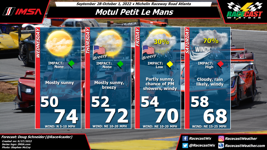
Key Messages and Impacts:
1) The remnants of Hurricane Ian will track across eastern Georgia on Saturday. Windy conditions will develop on Friday night and continue through Saturday. Sustained winds during this time are expected to be between 15 and 30 mph, with gusts of 40 to 45 mph. Possible impacts from the winds may be tree branches and/or weak trees blown down. This is a potential hazard for campers to be aware of and prepare for. Being in a tent on Friday night under trees may be hazardous; campers should consider finding sturdy shelter.
2) Rain is expected to spread into the area on Friday evening, with heavy rain at times from Friday night through Saturday. Between 2 and 4 inches is expected during that period, which may lead to flooding of low lying areas and small creeks and streams. There is a creek that runs behind the outer paddock area, past turn 1, and near the corner marshals' camping area. Camping near this creek should be avoided.
Forecast Discussion:
The main change to the forecast today is to push the timing of rain from the remnants of Ian later into Friday night and Saturday, to account for the slower forecast speed of Ian (click images to enlarge).
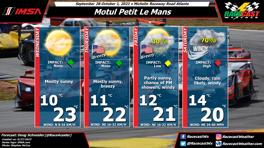
 |  |
The National Hurricane Center forecast as of 8 AM this morning is below. For the latest forecast from the NHC, click here.
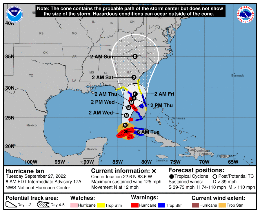
The forecast has shifted to the east, which is somewhat good news for impacts at Road Atlanta. This track takes the storm inland sooner than if it made landfall father west along the Florida Panhandle. This extra time over land will cause the storm to weaker more before its effects are felt in northern Georgia. Still, it will be getting quite windy starting Friday night and continuing through Saturday. Gusts of 40 to 45 mph are expected, which may be strong enough to blow down some weak trees or tree branches.
Below is the forecast rainfall graphic from the NWS Weather Prediction Center:
Below is the forecast rainfall graphic from the NWS Weather Prediction Center:
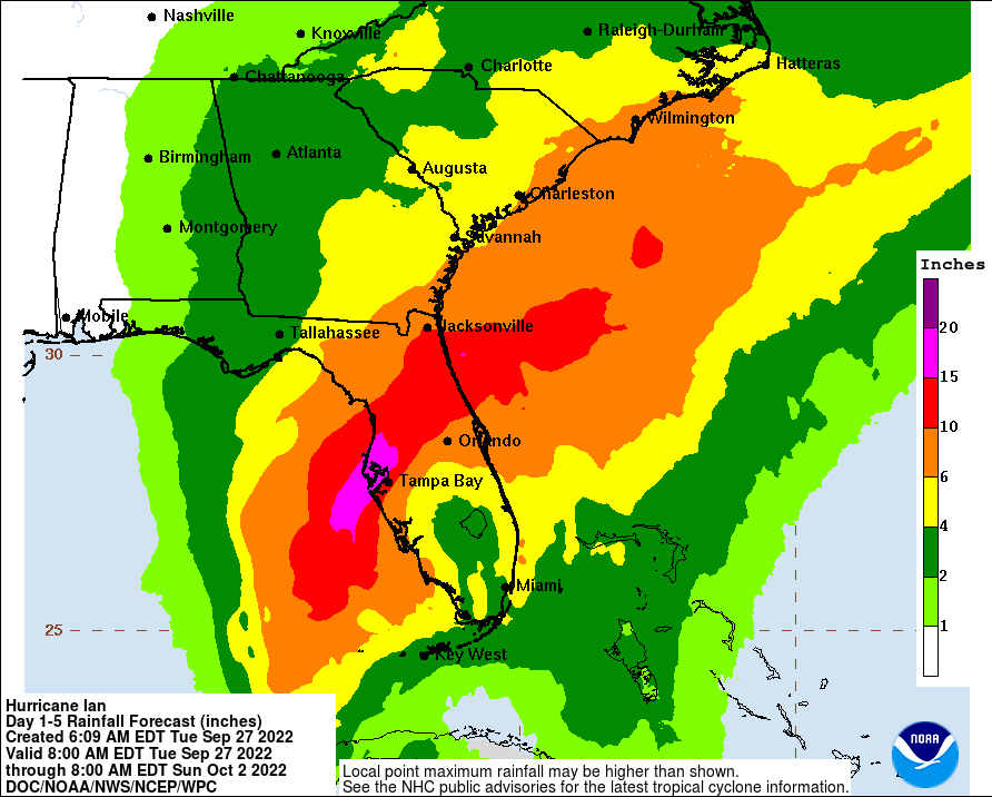
At Road Atlanta, between 2 and 4 inches of rain is forecast. Most of this is expected to fall from Friday night through Saturday afternoon. Avoid camping in low lying areas and near creeks, which will have a better chance of flooding.
In terms of how the racing will be affected, it will be a question of when a heavy shower passes over the track, and whether the rain can run off the racing surface quickly enough to avoid ponding. I think it is likely that there will be some red flag periods during Saturday's race. It is possible that the rain could ease up enough late in the day on Saturday to allow for improving conditions for racing. But it's still early to pin that down with any confidence.
Check back for updates, and be sure to follow @RacecastWx on Twitter, and RacecastWeather on Facebook and Instagram.


