
By: Stephen McCoy
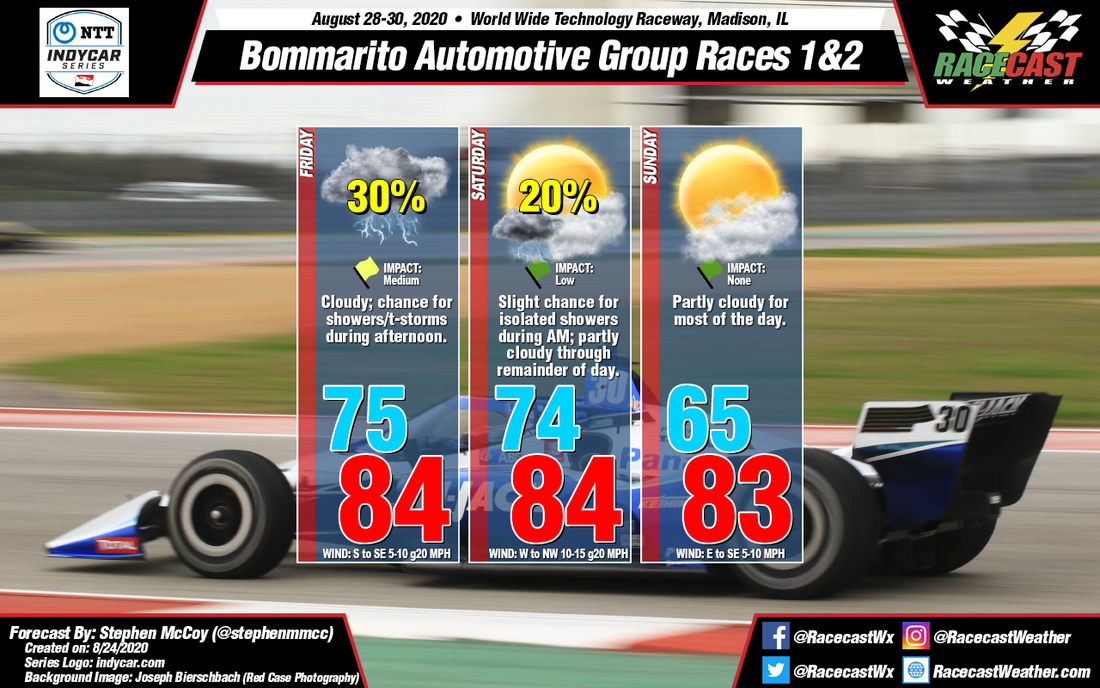
Near-normal conditions are anticipated at Word Wide Technology Raceway this weekend, though conditions on Friday and Saturday will be influenced by the remnants of a tropical system, followed closely behind by a cold front. Chances for precipitation exist for both days, though dry conditions will move in for the remainder of the weekend after noon on Saturday.
For Friday, the remnants of Tropical Storms (potentially Hurricane) Laura is expected to move to the south of the region during the day. Outflow from the system in the upper levels will cause mostly cloudy to overcast conditions starting in the morning and increasing in the afternoon as low level clouds start to build from the approaching post-tropical cyclone. Though the system will move close by the region, sustained wind speeds at the surface are only anticipated around 5-10 mph, however wind gusts could approach 20 mph. The outer edges of Laura will bring a chance for showers and/or thunderstorms to the St. Louis area, with timing potentially delaying a portion of Friday's practice session.
For Saturday and Sunday, as Laura is passing to the south on Friday, an upper level shortwave trough is expected to initiate development of a low pressure system over Minnesota/Wisconsin. Friday night into Saturday, the low is expected to move eastward through the Great Lakes region, with a cold front extending to the southwest. The front will move through the St. Louis region Saturday morning, bringing with it a slight chance for showers and/or thunderstorms. After the front passes, surface winds will increase from the west to northwest as high pressure begins to build in behind the low. Daytime heating will allow the maximum temperature to warm near Friday's high, though temperatures will decrease into the evening and overnight with a low in the mid-60's expected for Sunday. Northwesterly winds aloft will cause clearer conditions to move in Saturday afternoon, continuing through Sunday with the majority of cloud cover in the upper levels. During the day on Sunday, the surface high pressure system will track eastward, causing winds to shift east to southeast, allowing temperatures to warm with a high expected again in the mid 80's.


