If you're going to be at the track, don't forget the sunscreen, and be sure to drink plenty of water. Take frequent breaks in an air conditioned building, such as the TMI Racing Products store. And if you see a guy in a gray Racecast Weather polo shirt, stop and say hi - that's me.
By Doug Schneider 
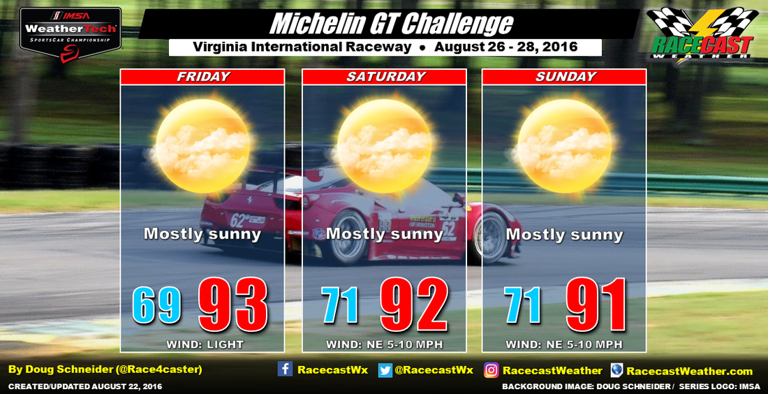
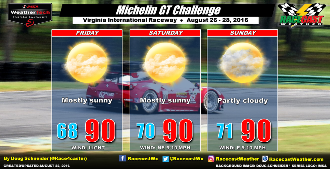
Not much change was needed to the forecast for VIR today as it looks like the dry pattern will hold up through the weekend. A large high pressure ridge through the mid and upper levels of the atmosphere will be sitting over the region, keeping any rain away from the track but also keeping temperatures rather hot. There will be a weak cold front that is expected to move through on Friday night, but it will have little impact on the weather as it will be lacking enough moisture for rain, and temperatures won't drop much behind it. The only change will be that winds will shift to the northeast behind the front on Saturday. In my previous forecast, I had considered putting in a slight chance of showers on Sunday, but I'm getting more confident today that a dry forecast for Sunday was the right call.
If you're going to be at the track, don't forget the sunscreen, and be sure to drink plenty of water. Take frequent breaks in an air conditioned building, such as the TMI Racing Products store. And if you see a guy in a gray Racecast Weather polo shirt, stop and say hi - that's me. By Scott Martin It is time for the return trip for the Verizon Indycar Series for the completion of the Firestone 600 at Texas Motor Speedway. As of now, it just looks like a typical summertime weather pattern for the area as a slight chance for an afternoon shower or thunderstorm is expected on Saturday, but any rainfall should diminish by the start of the race and should be no weather issues completing the remainder of the race. Daytime high is expected to be at or near 90 degrees, with the 8PM temperature expected to be in the mid 80s at the green flag. Temperatures at the drop of the checkered flag should be at or around 80 degrees. The odds of the track getting rain during the daytime hours is about 1 in 3.
I'll have updates through the week on our social media feeds and on our website. Have a great week. By Scott Martin. A surface high will be in control of the weather pattern over Road America for this week’s Trans Am action. Skies will be mostly clear, and temperature will be nice, as afternoon highs are expected to reach the mid to upper 70s. Weather should be the same on Friday, with mostly sunny skies and highs in the mid 70s. No rain is expected for both Thursday and Friday.
A trough will start to approach the area during the late evening hours on Friday and this will bring a slight chance of an isolated shower or thunderstorm for the day on Saturday, with better chances of thunderstorms on Saturday evening. Skies will be partly sunny throughout the day, and afternoon highs will reach the mid 70s. The overall chance for rain on Saturday is only 20% at this moment, and I’ll keep an eye on it throughout the week to see if this improves. Other than that slight chance of rain on Saturday, the weekend looks to be a great one at Road America. I’ll have updates on our social network feeds and on our website. Have a great week. By Doug Schneider The week leading up to the Michelin GT Challenge events at VIR will have beautiful weather as high pressure settles over the eastern states from the surface through the midlevels of the atomsphere. As teams load into the track on Wednesday and Thursday, there will be plenty of sunshine, high temperatures in the mid to upper 80s, light winds, and low humidity.
A cold front is expected to be located across the Ohio River and West Virginia by Friday morning, and push southeast through the day. It may produce some showers in the mountains, however, I don't expect it to have much impact at VIR for a couple reasons. First, it will have to cross the mountains, which tends to have a weakening effect in some situations. Second, there will be a large high pressure ridge in the midlevels of the atmosphere over the Carolinas that will also help to slow and weaken the front, and suppress any precipitation associated with it. With very little moisture available to work with and no upper level support, the front should be rain-free by the time it gets near the VA/NC border Friday night. The only effect from the front will be a shift of winds to the northeast on Saturday. With the strong midlevel ridge centered over the Carolinas, temperatures will likely be warm and slightly above normal, with highs around 90. Humidity levels will gradually be rising through the weekend as there will be a little more moisture spreading into the area due to east winds off the Atlantic Ocean. The increasing moisture may also produce a little more cloud cover on Sunday. Will there be enough moisture to produce some isolated afternoon showers and thunderstorms? That is not completely out of the question for Sunday, but I think the chance of that happening looks low enough to keep any rain chance out of the forecast - less than 20%. There appear to be more factors going against rain on Sunday than for it, but I will be watching this closely over the next few days. By Doug Schneider The title of this post might be a little misleading, because I don't expect that there will be much, if any, racing today at Pocono Raceway. Unless the start time is move up well before noon, it looks like the race will be a washout, and moved to Monday. I put the chance of any racing today at 10%.
By Doug Schneider
I'm very excited about the Michelin GT Challenge next weekend, as I'll be at the race, providing weather information and consulting to track officials. I've been watching the weather closely for next weekend, so I figured I'd make a post to share what I've been seeing. There has been relatively good model agreement on the general weather pattern for next weekend, but this far out, the finer details remain hazy. By Doug Schneider The bottom line today - It's not looking good for racing at Pocono on Sunday.
Saturday will likely be dry, and while I can't rule out an isolated shower or thunderstorm, I expect that practice and qualifying will be held on time with no weather interruptions. With mostly sunny skies, highs will reach the lower 80s. As we've been seeing over the past several days, a front and upper level trough will be approaching Pennsylvania from the west on Sunday. By midday, the front will be located across the central part of the state, and showers and thunderstorms will be increasing ahead of the front in eastern PA. There are some timing differences in the models, but I think that the most likely time period for rain at the track appears to be from 2 pm to 6 pm. This doesn't look like a light drizzle either - there could be some brief heavy downpours at times, and total rain amounts are expected to be a quarter to a half inch. I think the chances of a rain-out on Sunday are good, around 70%. With Sunday looking wet, I've added a forecast for Monday. Fortunately, if the race is delayed to Monday, the weather looks absolutely perfect. The front will be well east of the area, and drier and cooler air will be building in behind it. Highs will be around 70 degrees, with mostly sunny skies. By Doug Schneider Not much has changed with the forecast for Pocono Raceway this weekend. The pattern looks much the same as it did a couple days ago, with high pressure off the Atlantic coastline feeding moisture into eastern Pennsylvania from the southeast ahead of an approaching cold front and upper level trough. I've bumped up the chance of rain on Saturday, as the amount of moisture that will be in the area suggests scattered coverage of showers and thunderstorms in the afternoon. Sunday still has a good chance of some showers and thunderstorms, mainly in the afternoon. The timing of a cold front crossing the state from west to east still looks close to what it did on Monday, which gives me more confidence in the forecast. The chance that the race will be interrupted by rain is 50%.
|
Social Feeds
Authors
Doug Schneider Partners
Categories
All
Archives
December 2023
|