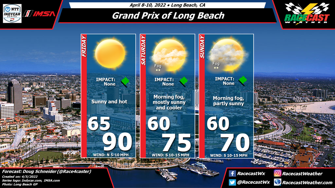
By Doug Schneider 
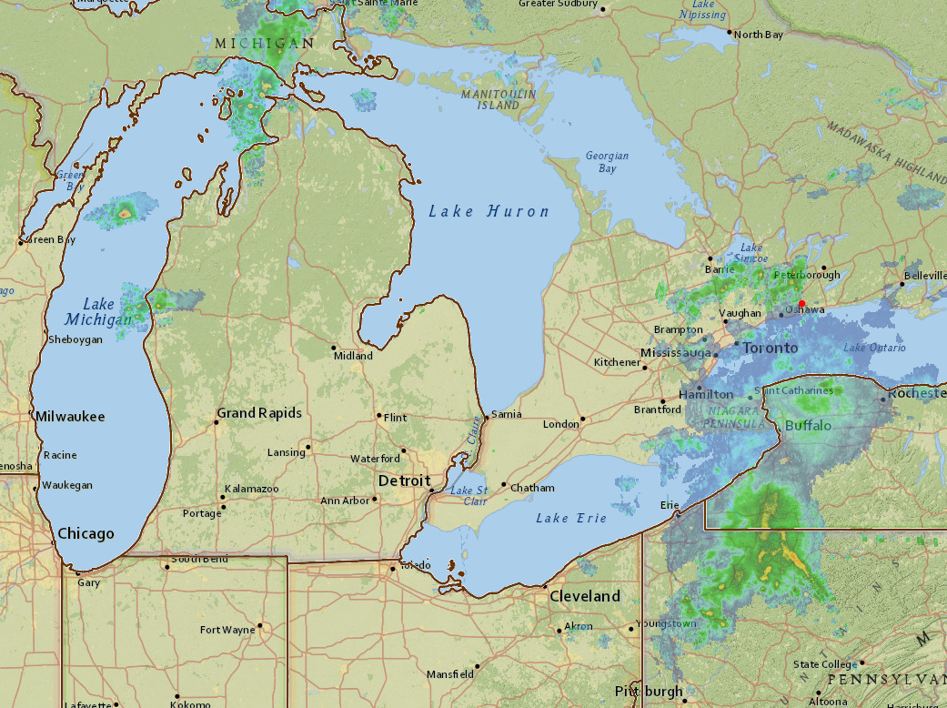
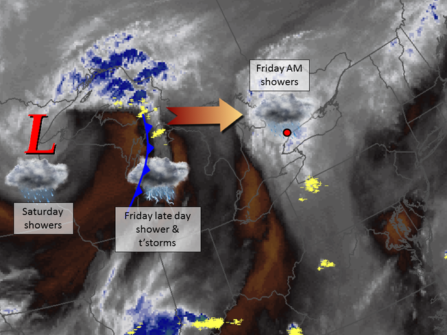
A cold front moved through Toronto yesterday, bringing showers to the city during the evening hours. Unfortunately, the rain might not be done as there will be a secondary cold front and upper level trough that will still have to move over the area today. But once these move through, there should be some really nice weather for the Honda Indy Toronto.
By Doug Schneider I'm feeling more confident about the forecast for Honda Indy Toronto, as the models are coming into better agreement on the timing of rain chances.
Thursday continues to have a high chance of showers and thunderstorms as a cold front will move across the Great Lakes area. There will be some instability ahead of this front, so some of the storms could be strong, with gusty winds, frequent lightning, and heavy downpours. Rain amounts are expected to be a quarter to a half inch. Friday will be when the upper level trough swings through, along with a secondary cold front at the surface. This will bring a good chance of showers in southern Ontario. However, with less instability in the atmosphere compared to Thursday, these showers are expected to be lighter, with very little chance of any lightning. I expect that rain amounts Friday will be less than a tenth of an inch. The timing of these showers appears to favor the afternoon. Temperatures will be cooler on Friday too, with highs in the mid 70s. Saturday will feature a high pressure ridge building over the Great Lakes. This should provide nice weather for the racing action, with a light north wind supplying comfortable temperatures as well. As the high moves to the east, winds will shift to the south. This will bring warmer temperatures on Sunday, and a few more clouds. I don't expect that there will be any rain on Sunday, but there is a low pressure system that could bring rain on Monday. If this system speeds up, it is possible that I will need to put a low chance of showers into the forecast late on Sunday, but right now, all signs point to a nice day for racing. By Doug Schneider I have to start this post by saying that there is a lot of uncertainty in this forecast. The models are not in good agreement with their depictions of when and where rain will fall around Toronto this weekend. The general weather pattern appears to be an unsettled one, with a broad low pressure trough in the mid and upper levels of the atmosphere. Weak disturbances passing around the trough will be the key to the rain chances, but this far out, it is difficult to pin them down.
By Scott Martin. No real change to the forecast for the Iowa Corn 300 weekend for the Verizon Indycar Series, the Indy Lights, and the USF2000 Series at Iowa Speedway. Skies will stay mostly sunny during the daytime with the nights being fair. An absolutely great weekend for racing. Be sure to stay hydrated, sunscreen up, and have fun!
By Doug Schneider Showers are moving across the Toronto area this morning. Here's a look at the radar at 8:30 am: The rain this morning may last about an hour or so, then there will be a long dry period for most of the late morning and early afternoon. Notice the showers over Lake Michigan this morning. These are located along a cold front that will be tracking east through the day. While there isn't much activity there now, showers and thunderstorms are expected to increase as it moves across Michigan and southern Ontario. This satellite image of water vapor shows the bigger picture of what's happening today and tomorrow: The white and blue colors indicate areas of higher moisture content, while brown indicates drier air. There is a good amount of moisture over Ontario this morning, then over Lake Michigan we see the cold front with some lightning strikes (yellow), The activity along the cold front is expected to reach CTMP late this afternoon. It could arrive as early as 4 pm, but I think the most likely time of arrival is around 6 pm. Qualifying for CTSC is between 5:10 pm and 5:55 pm, so it could be close as to whether it will be wet or dry. The total amount of rainfall from this morning through this evening will be between a quarter and a half inch. If you're at the track, stay aware of the weather and know where to find shelter when thunderstorms are nearby. You can use our radar link at the top of the page to keep track of what's coming. The movement of storms will be from west to east.
In the water vapor image, you can see an upper level low pressure system spinning counter-clockwise, centered over the western tip of Lake Superior. That is what will bring showers to CTMP on Saturday. Once the cold front moves through tonight, there will be a break in the rain until the upper level low moves overhead, which is expected to occur tomorrow. There could be showers any time of the day, but I expect that most of it will come in the afternoon when a little heating will help add some instability. The amount of rain on Saturday should be less than today, maybe around a tenth of an inch. Sunday still looks nice as the upper low tracks east and drier air builds in behind it. Expect partly cloudy skies and highs in the upper 70s. Here the updated forecast graphic: By Scott Martin. No real change to the forecast for the Iowa Corn 300 weekend for the Verizon Indycar Series, the Indy Lights, and the USF2000 Series at Iowa Speedway. The chance of rain that was in the forecast for Saturday night has been taken out as the idea of the edge of a MCS sweeping through the area is off of the table. Skies will stay mostly sunny during the daytime with the nights being fair. An absolutely great weekend for racing.
By Doug Schneider There have been some changes made to the forecast with today's update, as the models are showing a slower upper level low pressure system that will keep showers around CTMP on Saturday. But the good news is that it still looks like Sunday will have nice weather.
By Scott Martin. Fortunately for this weekend's hot racing action at Iowa Speedway, it will be falling in between two active weather periods for the area. Seasonal temperatures can be expected for the Newton area throughout the weekend, and rain chances will be next to none for the scheduled on-track times for any of the three series that are running at the track. With an upper level ridge in place over the central plains, there is a possibility of a mesoscale convective system (MCS) developing and moving through on Saturday night. If that happens, it will more than likely happen closer to the 8-10PM time frame. Just to be on the safe side, that is why there is a 20% chance of rain on Saturday night, especially after 6PM. Other than that, expect mostly clear skies during the day with fair nights, with afternoon highs in the lower to mid 80s, with early morning lows in the mid to upper 60s.
|
Social Feeds
Authors
Doug Schneider Partners
Categories
All
Archives
December 2023
|