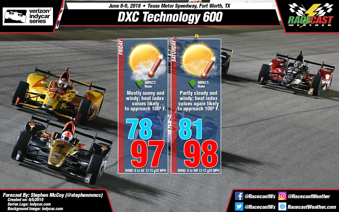
By: Stephen McCoy 
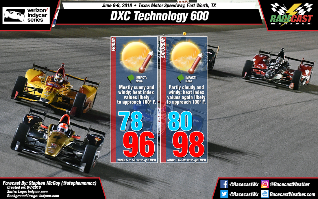
Very subtle changes to this forecast for the DXC Technology 600 at Texas Motor Speedway. Winds at the surface look to have some slightly lighter gusts from the south during the day, contributing to a degree or two difference in the high temperature for Friday and the low temperature for Saturday. Some upper level clouds are expected overnight in the area, but are expected to clear after sunrise. With little cloud cover and warm winds, heat index values are still likely to approach 100 degrees. Expect similar, if not slightly warmer, conditions for Saturday.
By: Stephen McCoy The forecast for the DXC Technology 600 still looks hot and windy for both days of on-track action. If you are planning on being at the track at any time this weekend, be sure to stay hydrated as conditions are expected to be very hot.
In the upper levels, a high pressure ridge has set-up over the southern Great Plains and will likely remain stationary through the end of the week. In the lower levels and at the surface, southerly winds will bring in moisture to the area from the Gulf of Mexico. Surface winds will be around 12-15 mph due to a surface low pressure system moving into northern Oklahoma; winds are likely to gust over 20 mph due to low level and surface winds both coming from the south. Conditions are expected to start partly cloudy on Friday as the tops of some strong thunderstorms in western Texas will reach the Dallas-Fort Worth are overnight. Once daytime heating and the low and mid-level winds begin to erode the cloud cover, conditions will clear and allow for lots of sunshine to heat things up. Temperatures will reach the mid to upper 90’s with heat index values approaching 100. Similar conditions are expected on Saturday, albeit a little warmer than Friday. With this forecast, I’ve also included a chart from iWeatherNet showing heat index values when looking at the air temperature. The temperatures in the highlighted box are values that are likely be seen on Friday and Saturday. If you want more information on heat index, be sure to follow the link below. http://www.iweathernet.com/educational/heat-index-calculator-and-conversion-table By: Stephen McCoy Welcome to summer in Texas for the DXC Technology 600 at Texas Motor Speedway, INDYCAR’s annual trip to the Lone Star State. Things usually heat up on track during this race, but this year the temperatures will too.
On Friday morning, an upper level high pressure ridge is expected to move over the southern plains, with the center of the ridge becoming stationary over eastern New Mexico and western Texas; a weaker, but still prevalent high pressure ridge is expected to set up in the mid-levels. Winds in the lower levels and winds at the surface are expected to be out of the south, bringing warm air off the Gulf of Mexico into the area; the latter of the winds being attributed to a surface low pressure system east of the Rockies. Some stronger gusts are likely as the winds will be from the same direction on Friday. With the mid-level ridge suppressing the heat and moisture off the Gulf, temperatures at the surface will heat up with the heat index values likely exceeding 100 degrees. On Saturday, calmer winds in the low-to-mid levels will trap more heat at the surface, resulting in warmer temperatures than Friday. By: Stephen McCoy For tonight’s update for the Le Mans test day on Sunday, conditions look to be relatively constant with previous forecasts. Expect partly cloudy conditions in the morning practice session and a low temperature in around 60 F, or the mid-teen’s C. Winds will be out of the east to northeast at 8-12 mph with some stronger gusts approaching 20 mph, or 14-20 kph with gusts at 32 kph.
The afternoon session is where I’d like to put emphasis due to the slight chance of showers in the late afternoon. Initially, the global models were indicating any kind of precipitation for test day, however over the past day the high-resolution regional models have trended more towards the same result. Current model runs are showing precipitation towards the end of practice, around 5:00-6:00pm local time. Because these showers could be scattered through the area, in addition to the timing, I’ve decided to indicate a low likelihood of delay for on track activities. By Doug Schneider Confidence is increasing that there will be a line of showers associated with a cold front that will move across Belle Isle in the late morning and early afternoon hours on Sunday. The timing window for these showers appears to be between 10 am and 2 pm. The activities that may be impacted are the IndyCar qualifying for Race 2 and Trans Am Race 2. If a heavier shower with lightning moves over the track, then delays are possible. I don't expect a lot of lightning, but a few cloud-to-ground strikes are possible. The good news that that the line of showers should pass through fairly quickly, probably lasting less than an hour and producing between a tenth and a quarter inch of rain.
I expect that the rain will be gone for the start of the Stadum Super Trucks race, which is scheduled for around 2 pm. After the showers move through, it will remain mostly cloudy through the day, with a west to northwest wind at 5 to 10 mph keeping temperatures cool in the lower 70s. By: Stephen McCoy For the Le Mans test day this Sunday, little has changed in the forecast as far as temperatures for the day; expect a low temperature around 60F, or in the mid-teen’s C, and a high temperature in the upper 70’s to low-80’s F, or the mid-to-upper 20’s C. Where things have changed are in the upper atmosphere. In the previous forecasts, the upper level low has been located off the western coast of Europe in the northern Atlantic Ocean. Because of this, winds were expected from the south or southwest. However, in the latest model runs, a secondary upper level low is expected to move through the Iberian Peninsula on Saturday and into the Mediterranean Sea early Sunday. The low will weaken on Sunday, however with the upper level low in the North Atlantic, the winds in the upper levels are expected to come from the southeast, bringing moisture from the Mediterranean into the region.
The ECMWF and GFS models, which are global forecasting models, both indicate some amount of precipitation towards the late afternoon and early evening hours on Sunday. However, the high-resolution European models are showing the majority of precipitation towards the southwestern portions of France. For the moment, I’m inclined to follow the high-resolution models, as they’re results take into account smaller-scale interactions between the land and atmosphere. Though I am confident for the moment for no precipitation for the test day, look for an updated forecast Saturday night into Sunday morning for a better look at the conditions for the day. With winds at the surface and lower atmosphere coming from the east to northeast, and now with upper level winds coming from the southeast, expect windier conditions than previously forecast with some stronger gusts in the region. |
Social Feeds
Authors
Doug Schneider Partners
Categories
All
Archives
December 2023
|