
By Doug Schneider
The models have been quite consistent from one run to the next this week, so this gives me more confidence that this forecast is going to work out well. There were not many changes that were needed with today's forecast update.
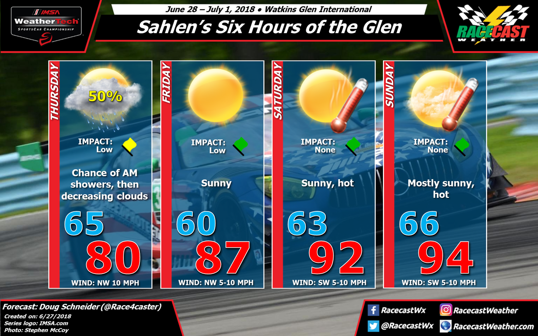
The pattern continues to be one that will produce a rain-free weekend, but hot temperatures. On Thursday, and front and upper level trough will cross the area, and the timing of showers with the front still looks to be mainly in the morning. Rain amounts Thursday morning could be in the range of a tenth to a quarter inch. Conditions will be improving through the day, with some partial clearing of clouds expected in the afternoon. As high pressure builds in from the west beginning on Friday, temperatures will be climbing each day, peaking in the mid 90s by Sunday. Humidity levels will also be increasing, and heat index values may approach 100 on Sunday afternoon. It will be important to take precautions to avoid heat stroke - take frequent breaks in the shade and drink plenty of water. Sunscreen will also be a necessity over the weekend.
The pattern continues to be one that will produce a rain-free weekend, but hot temperatures. On Thursday, and front and upper level trough will cross the area, and the timing of showers with the front still looks to be mainly in the morning. Rain amounts Thursday morning could be in the range of a tenth to a quarter inch. Conditions will be improving through the day, with some partial clearing of clouds expected in the afternoon. As high pressure builds in from the west beginning on Friday, temperatures will be climbing each day, peaking in the mid 90s by Sunday. Humidity levels will also be increasing, and heat index values may approach 100 on Sunday afternoon. It will be important to take precautions to avoid heat stroke - take frequent breaks in the shade and drink plenty of water. Sunscreen will also be a necessity over the weekend.


