The rest of the week continues to look dry, sunny, and warm as high pressure builds over the region. It's going to be a great weekend to take in the Le Mans experience. Wish I could be there!
By Doug Schneider - @Race4caster Click images to enlarge 
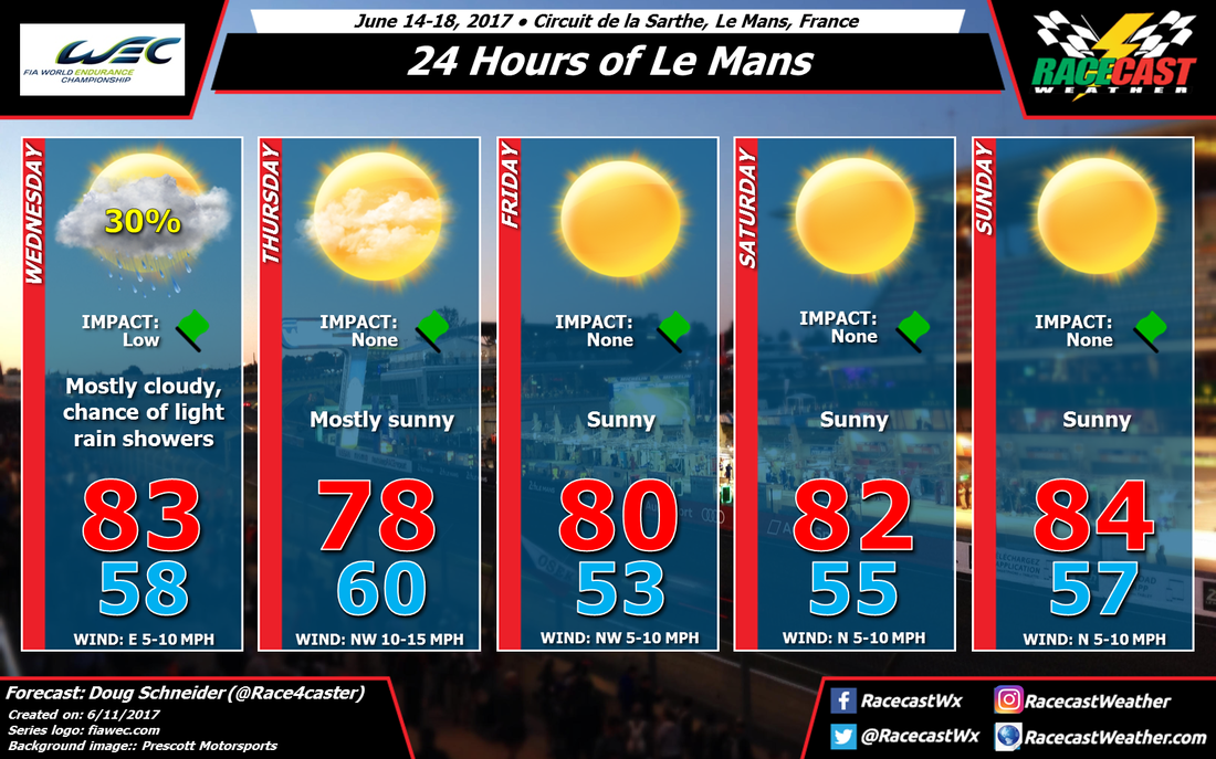
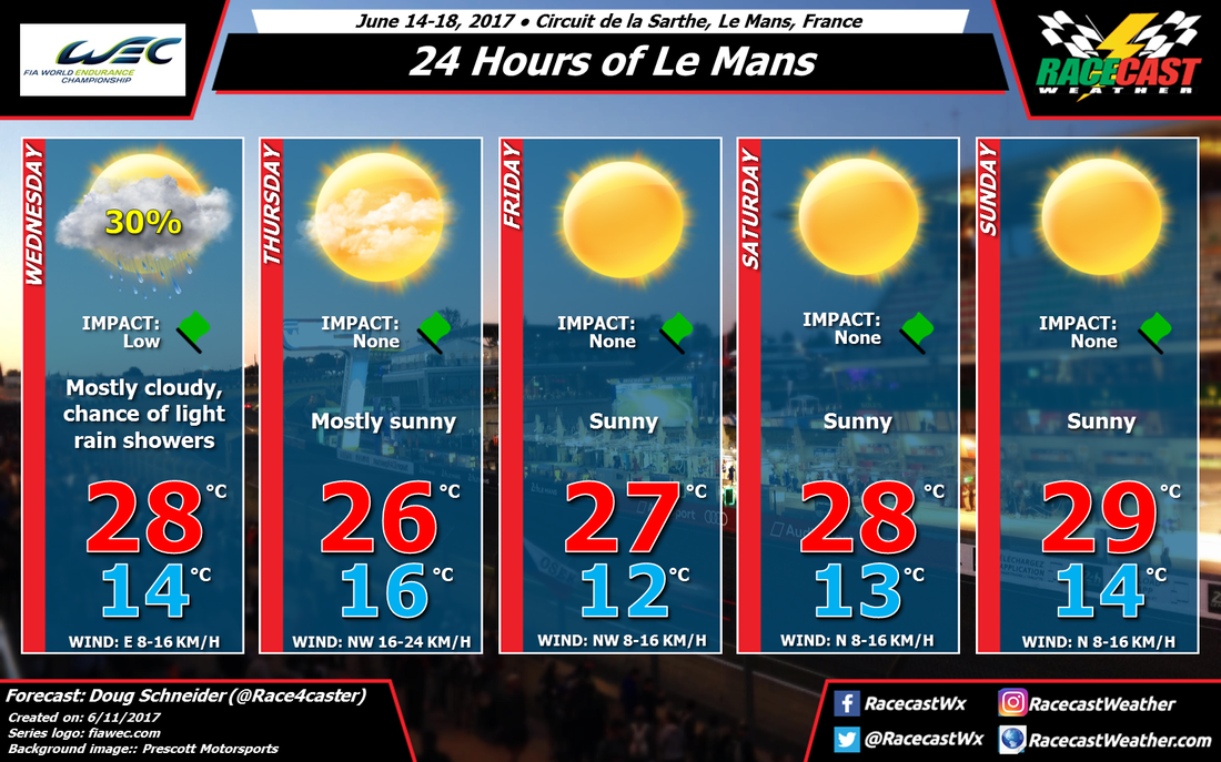
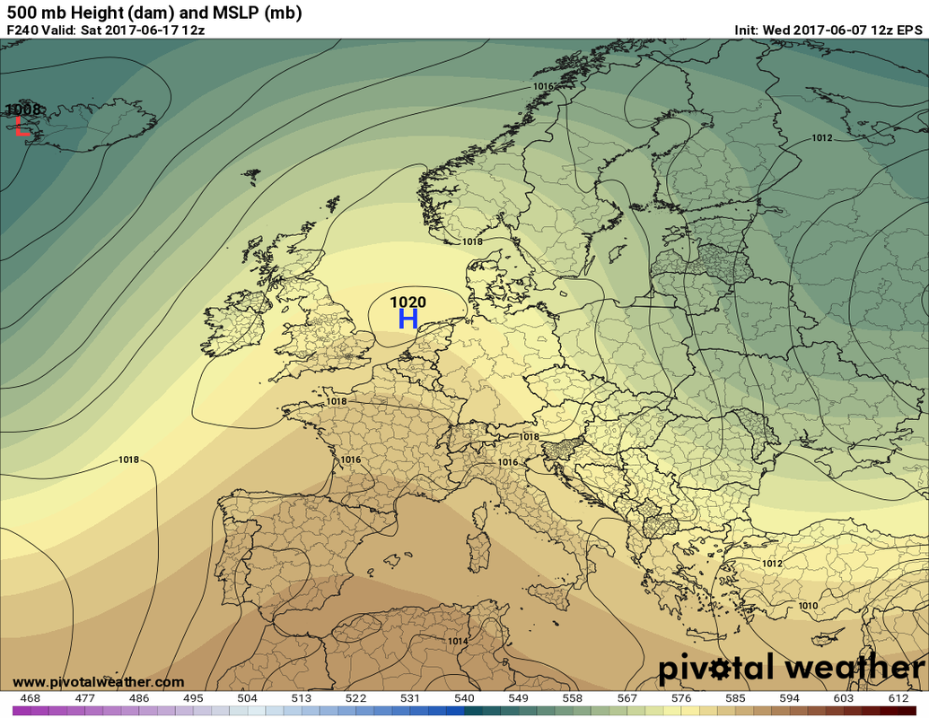
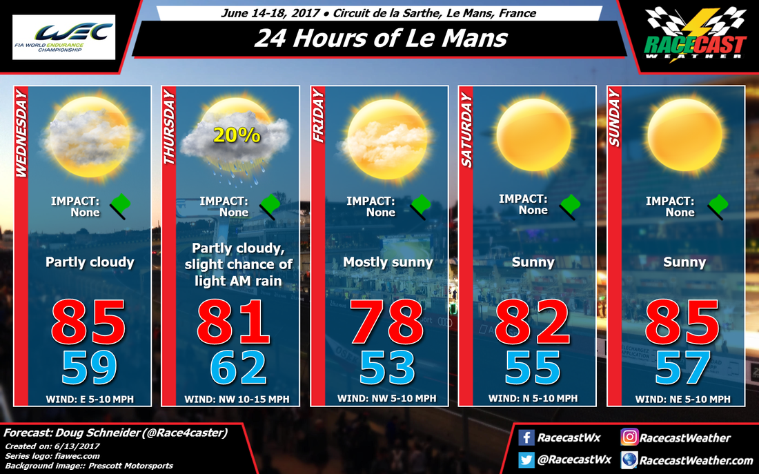
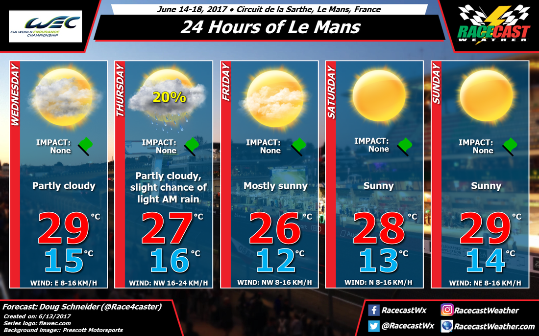
There hasn't been a significant change in my thinking for the forecast for Le Mans, except for a shift in the timing of rain chances from Wednesday to Wednesday night/Thursday morning. The low pressure system that I mentioned in the last forecast post is trending a little slower, which will push the chance of rain more into Wednesday night. There's just a slight (20%) chance of the rain continuing into Thursday morning as the low exits to the east. The amount of rain continues to look very light, and perhaps less than before - just a few hundredths of an inch, or a millimeter or two. So no impacts are expected at the track.
The rest of the week continues to look dry, sunny, and warm as high pressure builds over the region. It's going to be a great weekend to take in the Le Mans experience. Wish I could be there! By Doug Schneider - @Race4caster Click images to enlarge I'm not sure you could ask for much better weather for Le Mans week than what I'm expecting this year. There is good model agreement in the general weather pattern, so my confidence in this forecast is fairly high, which means I don't expect bug changes to it as we go through the week. Practice sessions begin on Wednesday, and that could be the only day that has a chance of rain. There is likely to be a low pressure system moving west to east across southern or central France that day. The position of the low will affect how much, if any, rain falls at the track on Wednesday. It may stay far enough south that no rain will fall, but I think there's enough of a chance to include a 30% probability of rain. It does appear that any rain will be light, so any impact on the practice session should be low. Amounts will likely be less than a tenth of an inch, or less than 2.5 mm. The rest of the week looks dry as surface high pressure will be centered off the west coast of France, providing a north to northwest flow across the country. Thursday may be a little breezy as the high starts to build in behind the low, with a northwest wind at 10-15 mph (16-24 km/h). Sunny skies with a slight warming trend are expected through the rest of the week and into the weekend. Unless there's a major shift in the pattern shown by the models, it's going to be perfect racing weather through all 24 hours. Follow me on Twitter and our Racecast Weather social media feeds on the right for weather updates through the week. By Doug Schneider The festivities for the 24 Hours of Le Mans begin this Sunday with the traditional scrutineering ceremonies at the Place de la République in the town center of Le Mans. There's always a big crowd on hand, as it provides fans an opportunity to get up close to the cars and drivers in a relaxed setting. The weather looks good for scrutineering this year. Sunday will have warm temperatures and plenty of sunshine, with highs in the upper 80s F and around 31 C. A cold front is expected to move across the area Sunday night, but with very little moisture to work with, the front is not expected to bring any rain. Even if there were some sprinkles, it would likely be overnight. Temperatures on Monday will be a little cooler behind the front, and winds will shift to the northwest. Early morning clouds will give way to plenty of sunshine by midday. The long term outlook for the week leading up to the big race looks promising for nice weather. The models are in general agreement that a large high pressure ridge through the lower and mid levels of the atmosphere will be across western Europe through the week and into the race weekend. Here's a depiction of what the pattern is projected to look like near the start time of the race next Saturday from the ECWMF Ensemble Prediction System: The colors represent heights at the 500 mb pressure level, so the ridge of orange colors over western Europe indicate a high pressure ridge through the midlevels of the atmosphere. The black lines are surface pressure, and we see the center of a high pressure area near Netherlands. This pattern will favor dry conditions and warm temperatures for Le Mans late in the week and the race weekend. Keep in mind that this is a forecast for 240 hours away, so things are likely to change somewhat as we get closer to the race. But so far, all signs point toward nice weather at Le Mans.
I'll have a forecast graphic for Wednesday through Sunday posted on Sunday, so be sure to check back then. By Doug Schneider The weather still looks good overall for IndyCar's visit to Texas Motor Speedway this weekend, but I have added just a slight chance of a storm on Friday with today's forecast update.
In my post on Monday, I mentioned some uncertainty about the rain chances on Friday. That chance looks slightly higher today, due to a little more moisture and instability that could be present, and a weak upper level disturbance. But I still think that it is highly likely (around an 80% chance) that all racing activities will be held without any weather issues on Friday. Saturday continues to look dry, with temperatures during the race from the mid 80s at the start to lower 80s by the finish. There will be a south wind at 10 to 15 mph with gusts near 20 mph, which could create a tricky crosswind in turns 3 and 4. By Doug Schneider A fairly typical weather pattern for north Texas is expected this weekend as IndyCar moves to Texas Motor Speedway, which should mean dry conditions with warm temperatures for the end of the week.
On Friday there will be a southerly flow in the low levels, which will bring some moisture off the Gulf of Mexico. However, there will be a ridge in the mid and upper levels of the atmosphere, which should provide stable conditions over north Texas that will suppress thunderstorms. There will be a dryline developing over west Texas in the afternoon, but it does not appear that there will be a lot of storms developing along it, and if they do, they will stay well to the west of TMS. I'm not 100% confident that there won't be an isolated storm on Friday evening, but the chances of rain at the track appear too low to mention right now. I'm more confident that Saturday will be dry, as the atmosphere looks like it will be drier and more stable than Friday. A dry northwesterly flow in the mid and upper levels will continue, and if storms are able to form on the dryline, they will stay well to the west. By Doug Schneider - @Race4caster The forecast for Detroit this week has been a moving target, but the pattern is starting to come into better focus as we get closer to the weekend. There are still some uncertainties about the timing of rain chances at Belle Isle, but the latest data point toward a better weekend for racing than previously indicated.
Friday looks like a nice day at the track, with mostly sunny skies and highs in the mid 70s. A cold front will be pushing south toward Belle Isle on Friday, but it isn't expected to move across the area until Friday night. The front will have very little moisture to work with, so there may not be any rain with it when it moves through. High pressure will be building over the area on Saturday, and the front will be to the south of Detroit, across northern Ohio. Most of the day will be very nice, with mostly sunny skies and highs in the mid 70s. However, as a low pressure system approaches from the west, a southerly flow will develop, spreading greater moisture into the area and pushing the front back to the north. While I think the majority of the rain with this will come after Saturday's racing ends, there is some uncertainty about timing, so I have just a 20% chance of rain late in the day, but with very low impact on the IndyCar race at 3:30 pm. No impact is expected for the Trans Am and IMSA races that will be held earlier in the day. Showers and thunderstorms are likely on Saturday night into Sunday morning as low pressure track east across Michigan, but the big question is, when will it end? There is a lot of uncertainty about this, but what I can say is that conditions should be improving through the day. The most likely sessions to be impacted by rain will be IndyCar qualifying and Trans Am Race 2. It is possible that there could be enough rain to cause some delays to these sessions, depending on how well water drains off the track.There will still be a chance of rain through the afternoon, but the chance will be lower than in the morning. I'd put the chance of rain in the morning at 60%, but closer to 40% in the afternoon. The Stadium Super Trucks and IndyCar Race 2 will probably have a wet track to deal with, but I don't think the conditions at that time will be bad enough to cause major delays or cancellations. We'll have our live radar feed going through the weekend - just use the Radar link at the top of the website. I'm going on a beach vacation with my family this weekend, so my weather updates on Twitter will be limited, but Scott (@RaceWx4You) will help to keep you informed of the latest weather conditions at Belle Isle. The forecast graphics for IMSA and Trans Am (Impact level differs based on the timing of races and expected rainfall): |
Social Feeds
Authors
Doug Schneider Partners
Categories
All
Archives
December 2023
|