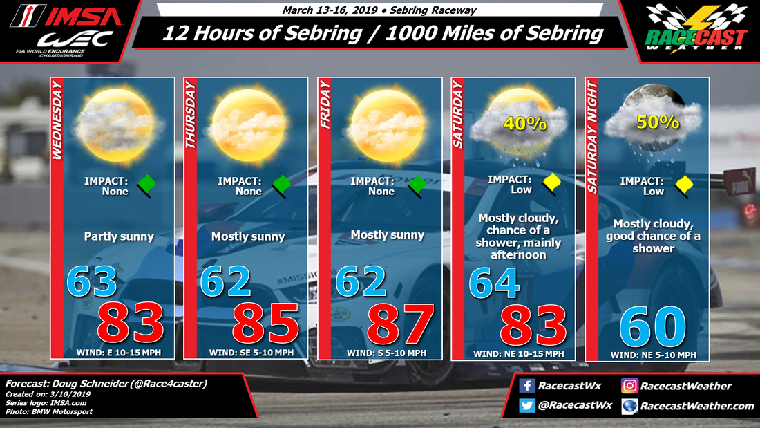
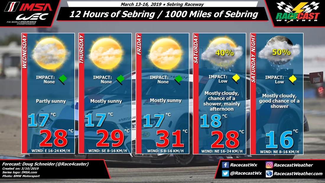
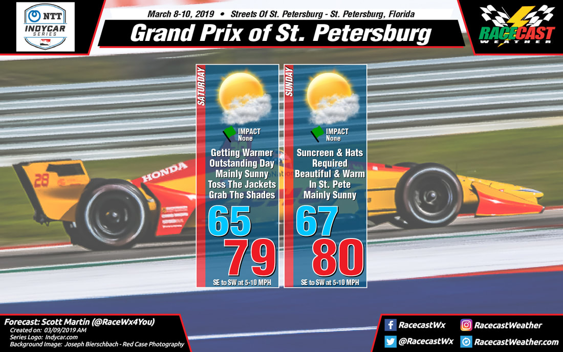
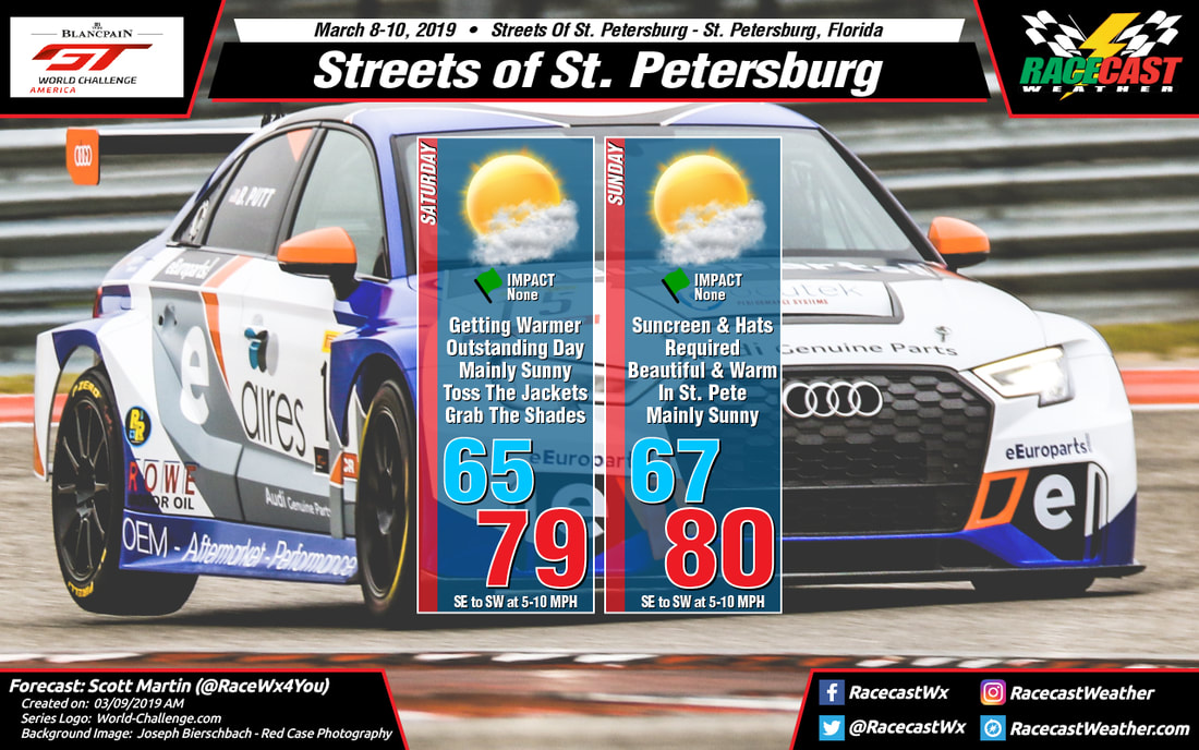
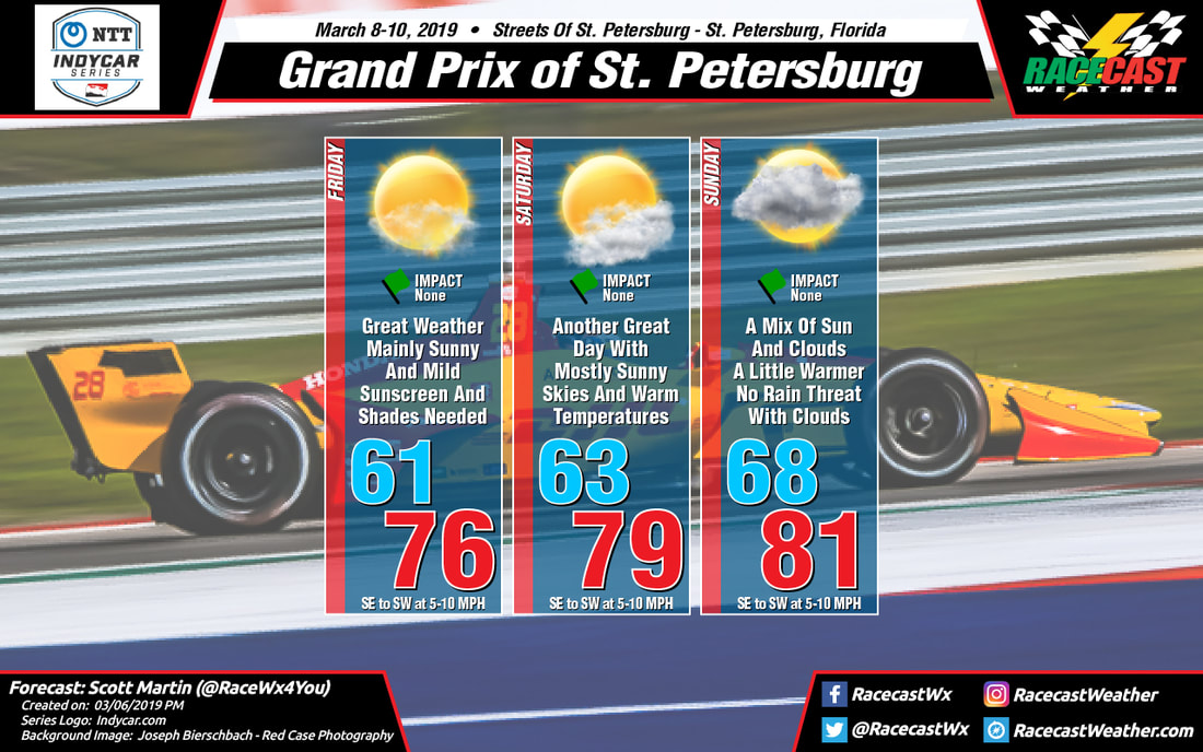
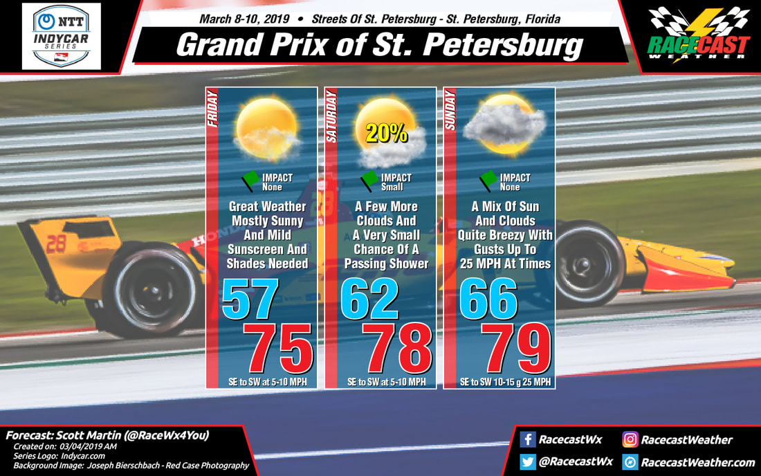
Racecast Weather - Your Source for Race Weather Information
  • Home
  • Racecasts
  • 2025 Schedule
  • Services
  • Contact
  • Bios
  • Links

Rain At Times Expected For Indycar At COTA

3/19/2019

Comments

 
By Scott Martin
Picture
Picture
GFS Model valid from Friday 7:00 am to Sunday 7:00 pm.
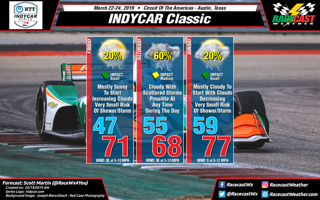
We'll, if you like to see the best racers in the world in the wet at Circuit of the Americas, you may get your chance this weekend as the NTT Indycar Series makes its inaugural visit along with Indy Lights.

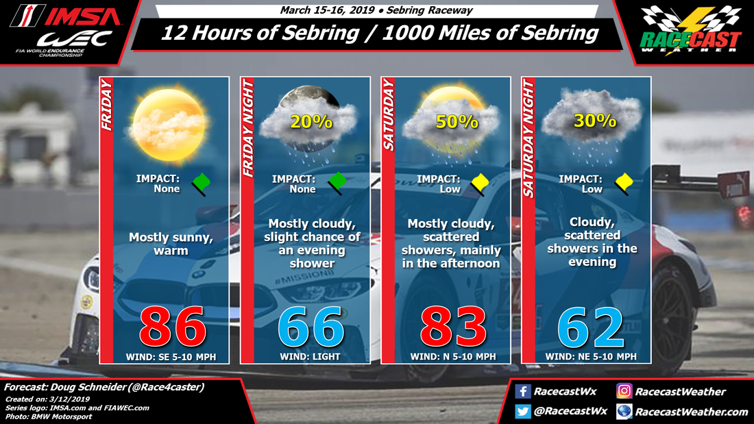
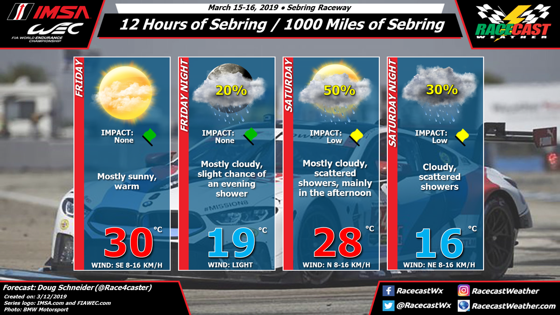
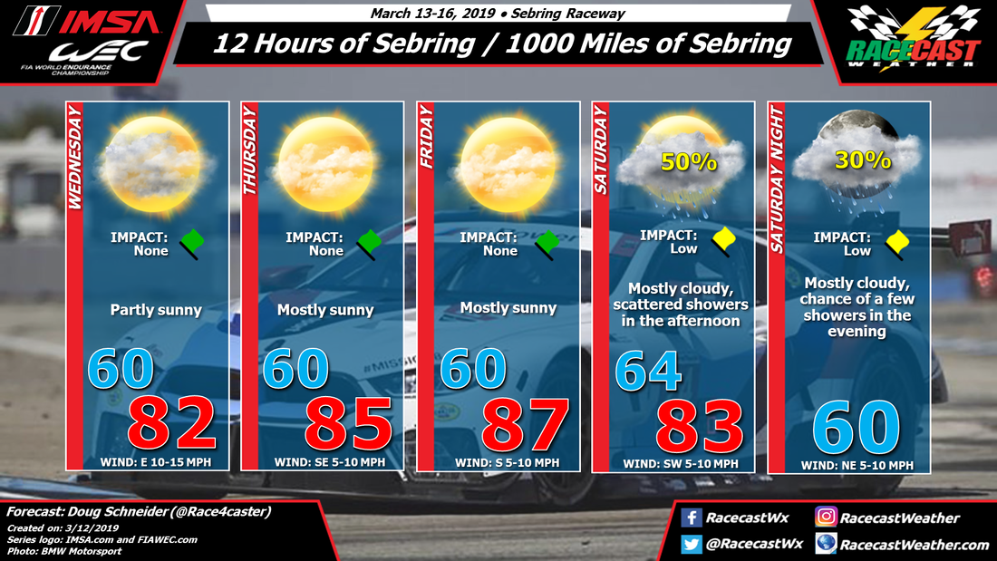
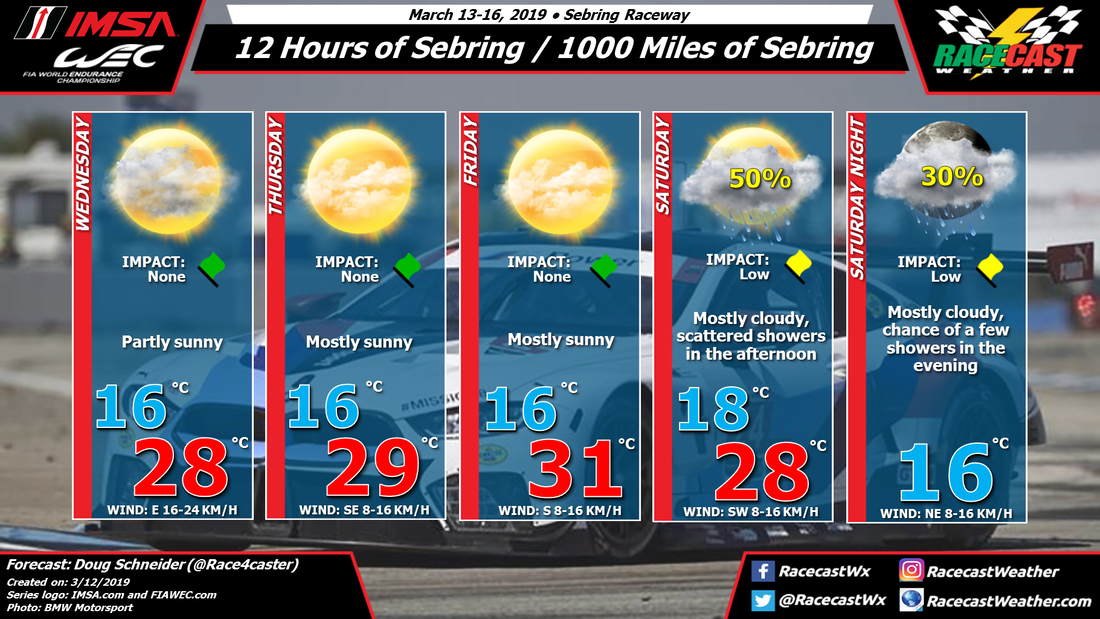
Friday morning will start off with mostly sunny skies with temperatures in the upper 40s to near 50 degrees at 8:00 am, but clouds will begin to build as the day progresses. Skies will be partly cloudy and we will begin to have a very small chance of a passing shower or thunderstorm through the rest of the on-track day, only around 20%. Afternoon highs will be in the lower 70s with dewpoints rising from the lower 40s to the upper 40s. Winds will be out of the southeast at 5-10 MPH.

Saturday looks to be a day that could be wet at times. We have the potential of scattered showers and thunderstorms moving across the track at anytime during the day. The good news is that the rain will not last all day long. At this point, these will be just general thunderstorms... no severe weather is expected at this time. With lightning expected, you still have to be weather aware and take cover inside a sturdy building (not a tent or temporary structure) or inside a hard-top vehicle (no convertables). Temperatures will start off in the upper 50s at 8:00 am and warm up into the upper 60s for the daytime high. Winds will be out of the southeast at 5-10 MPH. Chance of rain will be around 60%.

Sunday will be a mostly cloudy day to start with temperatures in the lower 60s at 8:00 am and we'll continue to have a very small chance of a passing shower or thunderstorm throughout the day (around 20%). Clouds will be slowly decreasing throughout the day with the exception if one of those scattered showers makes it to the track. Afternoon highs will be in the upper 70s. Winds will be out of the south at 6-12 MPH.

Please remember to take cover if lightning is in the area. Lightning can strike up to 10 miles away from the parent thunderstorm. If you can hear thunder, you are close enough to be struck. I'll have radar up and running by Friday morning. I'll have another update on Wednesday morning. Have a great day!
Comments

Friday forecast update for Sebring

3/15/2019

Comments

 
By Doug Schneider
Picture
Picture
The main change to the forecast today has been to add a slight chance of showers on Friday evening. It looks like there will be enough instability developing late in the day on Friday, along with a weak trough ahead of the main cold front that will allow for some showers to develop in the area. This may result in some rain during the WEC race, which ends at midnight. The chance of any rain is still quite low, only 20%, and if there is any rain, I expect it will be light. This is why I kept the impact as a green flag - it should not be enough to interrupt the action, and it may not even require rain tires. 

A cold front is still on track to cross the area on Saturday, which will bring a better chance of rain. The best chance of rain appears be mainly in the late afternoon and evening hours, although I can't completely rule out a shower at any time. The amount of rain still does not look especially heavy, and will most likely be in the range of a tenth ot a quarter inch. Still, there is some potential for up to a half inch through the afternoon and evening if multiple heavy showers pass over the raceway. I think this is unlikely though, and the race should be able to continue through any rain showers. 
Comments

Tuesday forecast update for Sebring - scattered showers expected on Saturday

3/12/2019

Comments

 
By Doug Schneider
Picture
Picture
Not much has changed in the forecast for Super Sebring weekend, but my confidence in the forecast is increasing and some details are coming into better focus as the models have remained consistent regarding a cold frontal passage that could bring some scattered showers to Sebring Raceway during the 12 Hours.

High pressure from the surface through the midlevels of the atmosphere will provide nice weather for Wednesday through Friday. Temperatures will be warm each afternoon but the humidity levels will be comfortable. Winds will be shifting from the east on Wednesday to southeast on Thursday to southerly on Friday as the surface high pressure center tracks east. 

A cold front is still on track to pass through central Florida on Saturday, and with it will come a chance of showers. The time period of potential showers looks to be from noon through the end of the race. But it will not be raining that entire time period. As I mentioned in my last post, this does not look like a prolonged moderate to heavy rain like what occurred at Daytona at all. The coverage of showers appears to be more scattered, which means that it is possible that the track could avoid seeing any rain at all. If a shower does pass over the track, it should not last for a very long time - the on/off nature of the showers should allow for any standing water on the track to run off.

While forecasting rain amounts this far out is difficult, my best estimate for rain amounts at this time is in the neighborhood of a tenth to a quarter inch of rain. Again, it is very possible that no rain falls at the track, which is why I have the chance of rain at 50% in the forecast. It is also possible that multiple showers cross over the track repeatedly and dump up to a half inch of rain. But as of today, I think the tenth to a quarter inch range is the most likely scenario.

Stay tuned for more updates over the next few days as we get into the time period where some higher resolution models can help provide more details on the timing and amounts of rain on Saturday.
Comments

First look at the forecast for Sebring - warm with a chance of rain for the 12 Hours

3/10/2019

Comments

 
By Doug Schneider
Picture
Picture
#SuperSebring weekend should be an awesome event as IMSA and WEC join up at the classic track. It looks like the weather will cooperate for most of the event, but it is possible that the 12 Hours on Saturday could see some light rain. 

A large high pressure area at the surface will be over the southeast as the event opens on Wednesday. In the upper levels there will be a high pressure ridge extending from the Caribbean across Florida and along the U.S. coastline. The surface high and the upper ridge will gradually shift eastward through Thursday and Friday. This pattern will provide sunny and warm conditions each day, with highs in the mid to upper 80s F, or upper 20s to lower 30s C. 

The eastward shift of the high and ridge will allow for increasing moisture and a cold front to move into Florida from the northwest on Saturday. As this front pushes south, it will help generate some scattered showers around the Sebring area. Timing of showers is uncertain this far out, but the afternoon hours appear more likely to have a chance of rain than the morning. The front is expected to be south of the track in the afternoon, which will shift winds to a northeasterly direction. Moisture aloft will continue to ride up and over this front Saturday night, and may keep some showers in the area. 

The good news is that this does not appear anything like what we saw at Daytona. The shower coverage is expected to be more scattered rather than a constant rain, and it does not look like heavy rain will occur. Things can certainly change this far out, but I have been watching the models for several days now, and they have not changed much from one run to the next. This gives me more confidence that this forecast will generally hold up through the week. 
Comments

Near Perfect Weather For Indycar & Blancpain GT World Challenge At St. Pete

3/9/2019

Comments

 
By Scott Martin
Picture
Picture
First of all, I want to apologize to the sports car fans for leaving out the graphics for the Blancpain GT World Challenge America series for this weekend's event at St. Petersburg. It's been a tough week in the weather office for me as we in Central Alabama are recovering from severe storms that swept through the area last weekend and gearing up for the potential of more severe storms this weekend.

The good news for St. Petersburg is that conditions probably could not be any better as we'll see plenty of sunshine with just a few passing clouds on both days. Highs will be approaching 80 degrees with morning lows starting off in the mid to upper 60s. Wind on both days will start off out of the southeast at 5-10 MPH but will eventually shift out of the southwest by the afternoon hours.

This will be the last forecast update for this event unless there are drastic changes that need to be made to the forecast. No radar on the site this weekend as well as I'll be utilizing it for severe weather coverage in Central Alabama.
Comments

Forecast Still On Track For Great Weather At St. Pete For Indycar Opener

3/6/2019

Comments

 
By Scott Martin
Picture
The good news is that the forecast still great throughout the event weekend at St. Petersburg for the NTT Indycar Series season opener. Maybe this will be bad news to some people, but I have removed the small rain chance on Saturday afternoon as a dynamic storm system will be affecting much of the southeastern United States with the potential of severe storms, but those will stay well to the north of St. Pete.

Other than bumping the chance of showers out of the forecast, the only other change that I made was actually bumping the temperatures up a little warmer... especially on Sunday as highs should top out in the lower 80s.

So the bottom line is... plenty of sunshine on Friday and Saturday with just a few passing clouds with highs in the mid to upper 70s and early morning lows in the lower 60s. We'll have a few more clouds across the skies making them partly cloudy, but we stay dry and warm. Afternoon highs reach the lower 80s.

We'll have radar up and running by Friday morning, but we will not need it. I may have to utilize it for severe weather coverage in Central Alabama on Saturday.

If you don't mind, send some thoughts and prayers to those affected by the deadly tornado that struck Lee and Macon counties in southeastern Alabama. We lost 23 people to a large EF4 tornado with estimated winds at 170 MPH. It was one of the toughest days of my young meteorological career. I just hope and pray that our weather this weekend in Alabama will not be that bad.
Comments

Nice & Mild In St. Pete For Indycar Season Opener

3/4/2019

Comments

 
By Scott Martin
Picture
It's going to be a great week as the season opener for the NTT Indycar Series at St. Petersburg is this weekend, and what a way to start off the season with nearly perfect weather.

Friday will start off the event with mainly sunny skies with only one or two clouds floating overhead throughout the day. The good news is that temperatures will be great as afternoon highs will reach the mid-70s. Winds will be averaging 5-10 MPH out of the southeast at first and shifts to out of the southwest by the mid-afternoon hours.

We'll have a few more clouds on Saturday, but there will still be more sun than clouds. There is a very small chance of a brief passing shower during the afternoon hours, but we are only looking at a 20% chance. Afternoon highs will be warmer, topping out in the upper 70s. Winds will be averaging 5-10 MPH out of the southeast at first and shifts to out of the southwest by the mid-afternoon hours.

Sunday will have a mix of sun and clouds throughout the day but we'll stay dry. The main difference will be winds will be breezy through the day and could gust as high as 25 MPH at times. Afternoon highs will once again top out in the upper 70s and may briefly touch 80 degrees. Winds will be averaging 10-15 MPH with gusts up to 25 MPH at times out of the southeast at first and shifts to out of the southwest by the mid-afternoon hours.

We'll have radar up and running by Friday morning, but we'll only need it for a brief time on Saturday. I'll have another forecast update out on early Wednesday morning, unless there need to be a major change. Have a great day!
Comments

Saturday update for Blancpain GT World Challenge America at COTA

3/2/2019

Comments

 
By: Stephen McCoy
Picture
Conditions for Sunday look to be much of the same as the rest of the weekend, with temperatures well below average. Northerly winds will cause Sunday's low temperature in the morning to be in the upper 40's with an afternoon high temperature only a handful of degrees warmer. Temperatures during the day might feel a couple of degrees cooler due to 15-20 mph winds with some stronger gusts likely. A chance of showers is possible overnight, with fog and/or mist present towards sunrise. Precipitation chances begin to taper off around mid-to-late morning as drier air moves in at the surface. Damp areas or areas of low standing water around the track could cause some of the earlier sessions to switch to rain tires, but this should be the largeest impact. Overcast conditions are expected to persist through the late afternoon, at which point conditions will start to clear due to dry air moving into the lower levels.
Comments
<<Previous
Forward>>

    Social Feeds


    Instagram


    Authors

    Doug Schneider
    Stephen McCoy

    Harris Cooley 


    Categories

    All
    F1
    IGTC
    IMSA
    Indycar
    Le Mans
    MRTI
    NASA
    Outlooks
    Photos
    PWC
    Racecasts
    SCCA
    SRO
    Trans Am
    TUSC
    Verification
    Weather Education
    WEC


    Archives

    February 2025
    January 2025
    December 2024
    November 2024
    October 2024
    September 2024
    August 2024
    July 2024
    June 2024
    May 2024
    April 2024
    March 2024
    February 2024
    January 2024
    December 2023
    November 2023
    October 2023
    September 2023
    August 2023
    July 2023
    June 2023
    May 2023
    April 2023
    March 2023
    February 2023
    January 2023
    December 2022
    November 2022
    October 2022
    September 2022
    August 2022
    July 2022
    June 2022
    May 2022
    April 2022
    March 2022
    February 2022
    January 2022
    December 2021
    November 2021
    October 2021
    September 2021
    August 2021
    July 2021
    June 2021
    May 2021
    April 2021
    March 2021
    January 2021
    December 2020
    November 2020
    October 2020
    September 2020
    August 2020
    July 2020
    June 2020
    March 2020
    January 2020
    December 2019
    November 2019
    October 2019
    September 2019
    August 2019
    July 2019
    June 2019
    May 2019
    April 2019
    March 2019
    February 2019
    January 2019
    December 2018
    November 2018
    October 2018
    September 2018
    August 2018
    July 2018
    June 2018
    May 2018
    April 2018
    March 2018
    February 2018
    January 2018
    December 2017
    November 2017
    October 2017
    September 2017
    August 2017
    July 2017
    June 2017
    May 2017
    April 2017
    March 2017
    February 2017
    January 2017
    December 2016
    November 2016
    October 2016
    September 2016
    August 2016
    July 2016
    June 2016
    May 2016
    April 2016
    March 2016
    February 2016
    January 2016
    December 2015
    November 2015
    October 2015
    September 2015
    August 2015
    July 2015
    June 2015
    May 2015
    April 2015
    March 2015
    February 2015
    January 2015
    December 2014
    November 2014
    October 2014
    September 2014


Powered by Create your own unique website with customizable templates.