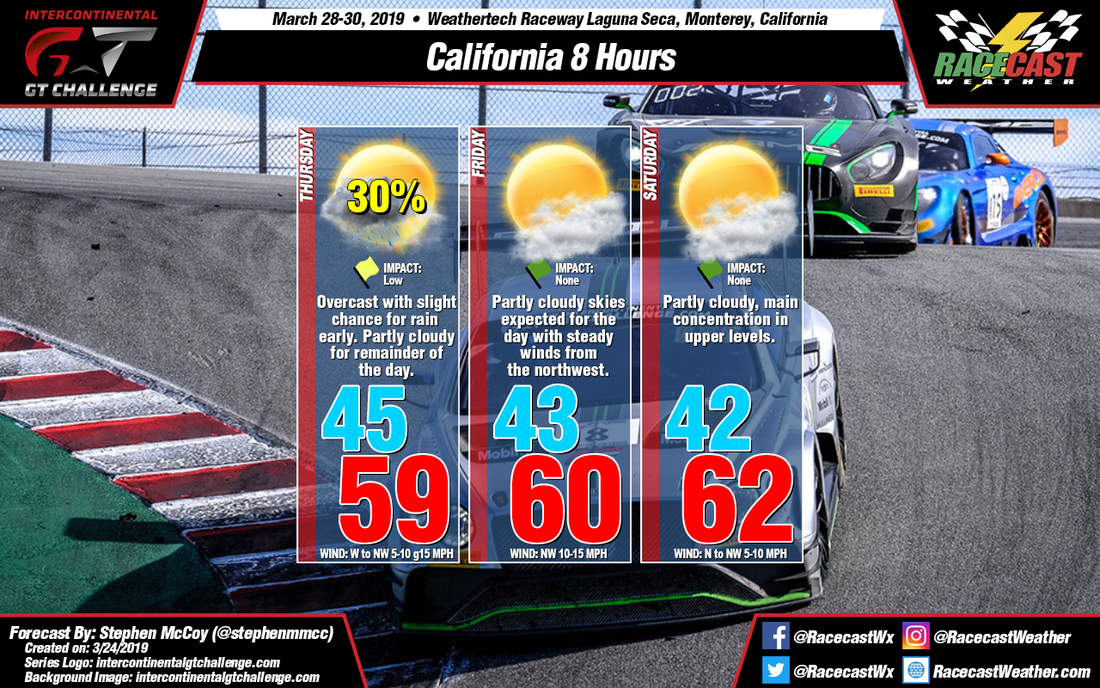
A trough in the upper levels over the Pacific Ocean is expected to move eastward towards the continental U.S. early this week. This trough will lead to the development of two surface low pressure systems in the Pacific off the west coast. The first system is expected to remain off the coast, moving northward into the mid-week. The cold front from this system will impact the region Monday and Tuesday, bringing high chances for precipitation to northern California. The second low pressure system is expected to be slightly stronger, with the cold front moving through the region on Wednesday, extending overnight into early Thursday. Much of the precipitation will exist along the front, however some lingering moisture from southwesterly flow in the lower levels of the atmosphere could threaten some of the earlier sessions on Thursday morning.
Winds Thursday morning will initially be from the south/southeast off the Santa Lucia Mountain Range before shifting to the west/northwest as the low pressure system moves north along the coast. Low level winds also from the west/northwest will cause some breezy conditions with gusts approaching 15 mph. The wind direction is expected to bring some moisture off Monterey Bay, resulting in partly cloudy conditions mid-day onward, though dry conditions aloft will decrease precipitation chances for Thursday afternoon and evening.
The rest of the weekend is expected to remain dry, with conditions on Friday and Saturday very similar to each other. An area of high pressure will build in behind the cold front on Wednesday/Thursday and move north up the coast during the weekend, keeping winds consistently from the north/northwest other than the mornings, where winds will again come from the south/southeast off the Santa Lucia Mountain Range. Winds on Friday are expected to orient in a more northwesterly direction which will bring some moisture off the bay and resulting in some partly cloudy conditions in the low levels. Saturday's winds are expected more from the north, resulting in fewer low level clouds as the winds traverse over more land than the water. However, an upper level ridge is expected to set up over the Pacific Ocean, funneling moisture from the equator to northern California. This could cause some upper level partly cloudy conditions to develop during the day on Saturday, but should have no impact on the race.


