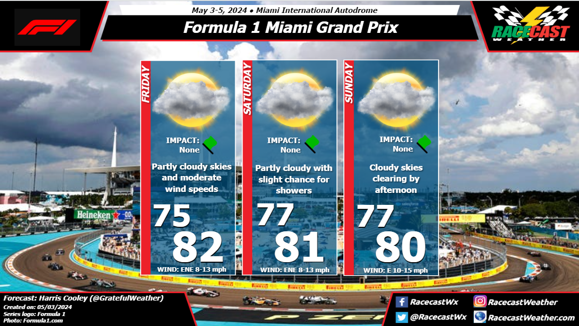
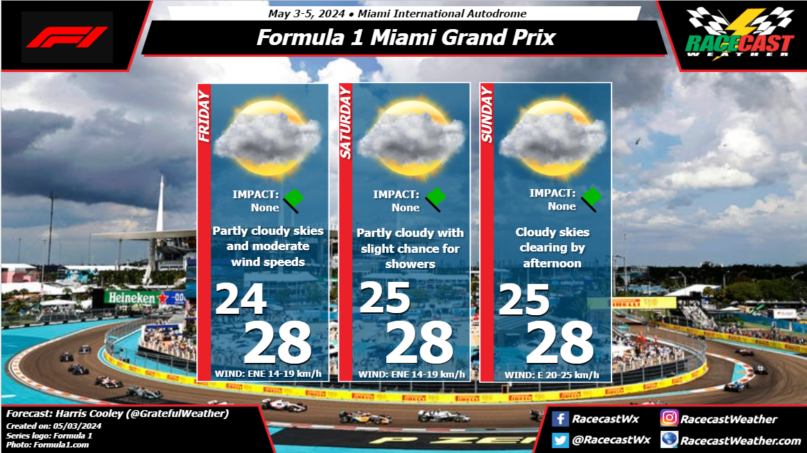
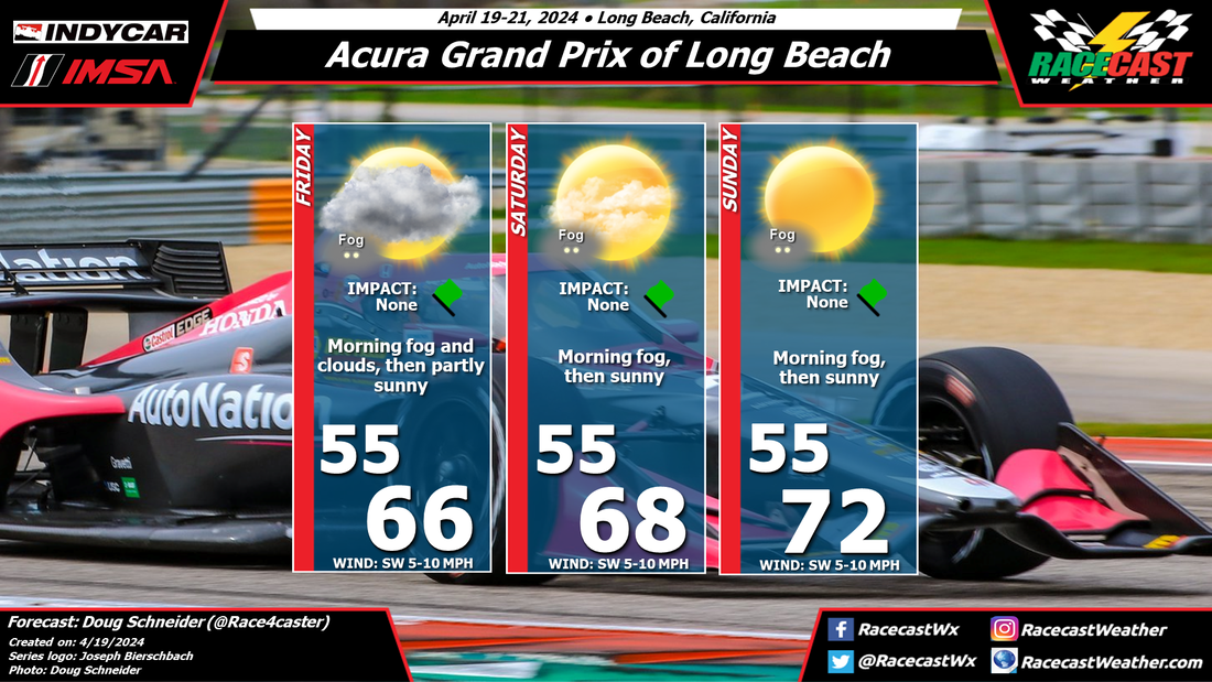
By: Harris Cooley A frontal boundary bringing a squall line through the region will be passing Friday morning into the early afternoon. The timing of this line will be impactful to the quality of practice session the teams can get. The skies clear and temps stay mild for the rest of the weekend with low wind speeds as well. Track temps could hot in the late afternoons if cloud coverage dissipates, though this should be a manageable variable for the teams. A metric graphic is pasted below...
By Doug Schneider Not much has changed in the expected weather pattern this weekend over Indiana. An upper level trough and a surface cold front are expected to cross the area Saturday night and Sunday. The frontal passage on Saturday night will bring some showers, and the upper trough will linger over the area through Sunday. This trough will create some instability that will produce scattered showers around central Indiana during the day. The chance of a shower at the track is about 30%. Showers are possible any time of the day, but the best chance is in the afternoon. I expect that any showers on Sunday will be light and short-lived, with low impacts on the racing. I don't expect any delays or red flag periods due to rain or lightning.
By: Harris Cooley Low pressure will be keeping wind speeds steady and moisture high. Partly cloudy skies will be present Friday and Saturday with warm temps during the practice sessions. Moderate winds will bring gusty conditions to the streets of Marina Bay which could cause some traction issues.
Sunday will be rainy in the early afternoon with scattered showers rolling through the area. Wind speeds will be low with warm temps. If the rain lingers into the night time, the glare from the puddles as well as slick conditions could make this race quite difficult for the drivers. By Doug Schneider A nice weather weekend is expected as IMSA returns to Indianapolis Motor Speedway. A large high pressure system will be sitting over the area to start the event on Friday, providing mostly sunny skies and pleasant temperatures and humidity. Through the weekend, this high will shift east, and a low pressure trough in the mid and upper levels will approach the area on Sunday. This will bring an increase in cloud cover, and possibly a few showers. The good news is that moisture appears limited as the trough moves through on Sunday, so if there are any showers at all, they should be light and short-lived. I don't expect any significant impacts to the race at this time, but I'll keep an eye on it as we get closer to the weekend. Stay tuned for updates through the week.
By: Harris Cooley A mostly clear weekend is in store for the Italian GP at Monza this weekend with very light winds and partly cloudy skies. Upper-level winds are conducive for afternoon showers in the area, but the chances are quite low as these showers would be short-lived anyway. Sunday should have a nice, clear afternoon for the drivers to show their stuff. Higher pressures loom over the surface of the region keeping drier air in the area. The main threat will be tire/track temps heating up should the cloud coverage dwindle. A metric graphic is posted below...
By Scott Martin Unfortunately, it looks like we will be dealing with storms today as the 8:30 am radar shows strong to severe storms northwest of the St. Louis metropolitan area and is pushing to the southeast. Models do not have this activity diminishing anytime soon. Maybe, just maybe, we can get enough of a dry slot to set up this evening for cars to hit the track, but the risk of scattered storms remains high through the remainder of the day. The good news is that Sunday will be a brilliant day with plenty of sunshine and lower humidity. Sunscreen and shades are highly recommended. Please stay weather aware today.
By Scott Martin Looking at the latest model runs for this weekend, we may have to put up with a passing storm on Saturday as a cold front will be working through the area, but will make it feel much nicer and less humid on Sunday. The good news is that the models are not too bullish on the rain activity on Saturday, but convective storms are usually not handled well by the models sometimes. I'll keep a chance of storms in the forecast on Saturday afternoon and early evening.
Sunday will be a very nice day with temperatures in the lower 80s and low humidity. There will be a mix of sun and clouds, and I just can't rule out an isolated shower during the afternoon to early evening, but with the amount of dry air in place, chances will be very, very low. By Doug Schneider Some changes were made for this forecast update for IMSA's VIR weekend. While the chance of rain has lowered on Saturday, the chance has increased on Sunday.
The models have not done a great job with how they handle a cold front that moves southward through Virginia and North Carolina this weekend. This makes for an uncertain forecast. What I am confident about is that temperatures on Friday will be hot, with highs in the mid 90s and a heat index around 100 to 105. Most of the day will be dry, but there is a slight chance of showers and storms moving into the area late in the day, mainly after 5 pm. A weak front or low pressure trough will be associated with these showers, and will move through in the evening hours. It will shift winds to the north, and bring slightly lower humidity for Saturday. There will still be some instability in the afternoon that may allow for isolated showers and storms to develop. Again, most of the day will be dry, with only a small chance of showers late in the afternoon. Another front moves in from the north on Sunday, and may initiate showers and thunderstorms in the afternoon. With more cloud cover, temperatures will be cooler, in the 80s. |
Social Feeds
Authors
Doug Schneider Partners
Categories
All
Archives
March 2023
|