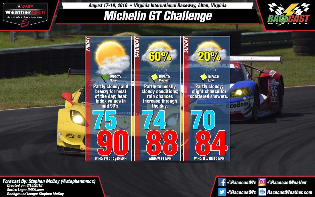
On Friday, an upper level shortwave trough will be centered over the Midwest. Winds at this level will be from the southeast, which would normally bring moisture into the region. However, a pocket of dry air originating over the Gulf coast on Wednesday will be transported to southern Virginia by these winds. In the mid to low levels, winds will bring moisture from the southwest, though with dry air aloft cloud cover will be concentrated mainly at the lower levels. At the surface, winds will also be from the southwest as a low pressure system will be to the north over the Great Lakes and a high pressure system will be to the southeast over the Atlantic. With the vertical stack of winds from the southwest, surface winds will be moderate with some stronger gusts possible. The surface pressure systems are expected to funnel moisture from the Gulf of Mexico through the southeast, raising dew point temperatures throughout the region. As a result, heat index values for the track will likely reach the mid 90's.
As the surface low pressure system moves eastward from the Great Lakes on Friday, a surface trough is expected to extend southwest from the center of the system. A squall line will likely set up along this surface trough towards mid-day and progress eastward with the low pressure system. There is a chance that the squall line could produce precipitation at the track, however it should reach the track after activities have concluded for the day, though it may disrupt some dinner plans.
The aforementioned upper level trough will continue to bring moisture from the west and southwest along with winds in the low to mid levels from the same direction. Moisture in the atmosphere will gradually increase on Saturday, increasing chances for precipitation in the afternoon and evening and will likely affect the various on-track sessions during these times. There is some disagreement among the models, though as the latest runs of the GFS show precipitation occurring overnight Friday, then remaining dry on Saturday. The ECMWF and NAM, however, both lean towards precipitation during the day. The surface low pressure system mentioned for Friday will continue to move eastward towards the north Atlantic Ocean on Saturday. A cold front extending west from the system will remain north of the track while another surface trough will stay to the east; without either of these lifting mechanisms, thunderstorms are unlikely.
Upper level flow will return to more zonal conditions on Sunday, with winds directly from the west throughout the day. The cold front extending from the surface low pressure system will slowly track southward towards the region, bringing a slight chance for scattered showers. With the passage of the front, temperatures will cool to the mid to low 80's, however with surface winds from the northeast, dew point temperatures will reach the upper 60's to low 70's. The resulting heat index will be in the low 90's.


