
By: Stephen McCoy
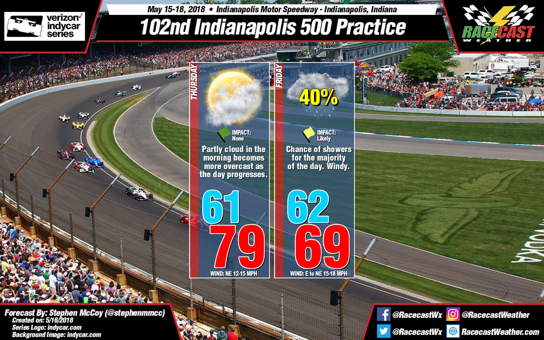
Not much has changed in the forecast for Thursday. Look for a slight increase in the sustained winds during the day as a moderate pressure gradient sets up over Michigan and southern Canada.
For Friday, a low pressure system over the southeast bordering the Gulf of Mexico is expected to track northward. For the most part, the model consensus is that this low pressure system will move due north into the Midwest, bringing a lot of moisture into the area. However, the higher resolution NAM 3km model has the low pressure system tracking more towards the northeast, avoiding the Midwest altogether. But, since this output is an outlier at the moment, I am inclined to follow the model consensus for this forecast. As discussed in the last forecast, at the upper levels, winds are expected to shift towards the south, bringing more moisture in the upper levels into the area, and with it a more likely chance for rain. With the approach of the low pressure system, the pressure gradient mentioned for Thursday will strengthen, bringing a slight increase in wind speeds from the east to northeast and cooler daytime temperatures. There is a chance of showers beginning before sunrise and continuing throughout the day and will likely disrupt the first few hours of practice.
For Friday, a low pressure system over the southeast bordering the Gulf of Mexico is expected to track northward. For the most part, the model consensus is that this low pressure system will move due north into the Midwest, bringing a lot of moisture into the area. However, the higher resolution NAM 3km model has the low pressure system tracking more towards the northeast, avoiding the Midwest altogether. But, since this output is an outlier at the moment, I am inclined to follow the model consensus for this forecast. As discussed in the last forecast, at the upper levels, winds are expected to shift towards the south, bringing more moisture in the upper levels into the area, and with it a more likely chance for rain. With the approach of the low pressure system, the pressure gradient mentioned for Thursday will strengthen, bringing a slight increase in wind speeds from the east to northeast and cooler daytime temperatures. There is a chance of showers beginning before sunrise and continuing throughout the day and will likely disrupt the first few hours of practice.


