
By Doug Schneider
I will say up front that I don't have high confidence in this forecast. There are a lot of places where this forecast could be a bust. Even today, the models are showing very different scenarios that could happen with the weather on Wednesday, Thursday, and Friday, particularly in regard to how much rain might fall. This forecast is my best estimate, and I'm leaning toward a more positive (drier) outlook. However, I may be biased because I'll be attending the race.
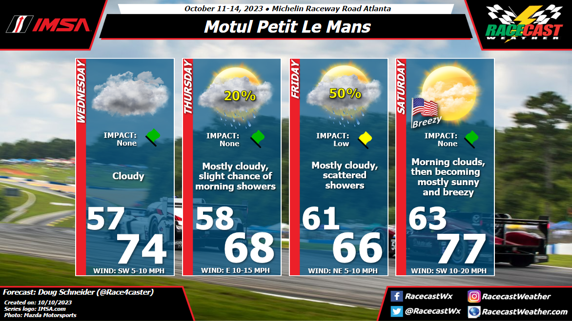
The tricky part of the forecast for Wednesday and Thursday is a tropical low pressure system that will be tracking east along the Gulf Coast region. While the low will stay well south of Road Atlanta, moisture from the Gulf is expected to spread northward across Georgia. On Wednesday, I think it will be mainly cloud cover, with no rain expected. However, rain may spread into the area Wednesday night. This would impact campers at the track, but I expect the rain to be gone by the time track activates begin on Thursday morning. Some models hang onto some rainfall through the daytime Thursday, but most clear out the rain and some of the clouds. The small chance of rain in my forecast is just for the early morning hours, and I think it will be mainly a dry day with some sunshine breaking through in the afternoon.
An upper level disturbance is expected to cross the area on Friday, but there are big differences between the models in regard to how much rain it produces. Some produce no rain, others produce an inch or more. I think there's a good chance of seeing some rain on Friday, but I lean toward the models that show only light amounts, given how fast this disturbance moves through and the weak lift that it produces. I think rain amounts between a tenth and a quarter inch is the most likely scenario.
On Saturday, there may be some clouds to start the day as the disturbance exits to the east, but clouds will decrease through the day. Mostly sunny skies and a breezy southwest wind will warm temperatures into the mid to upper 70s. A cold front will be approaching from the west, and will cross the area Saturday evening. Winds will shift to the northwest, and temperatures Saturday night will fall into the lower 50s.
I plan to have another forecast update posted on Thursday afternoon.


