
By Scott Martin
Not really that much change made from the previous forecast to now, but I am having to raise the chances for rain and thunderstorms on Sunday.
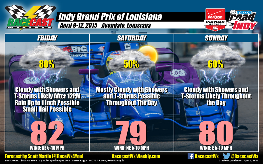
FRIDAY
A cold front will begin to move into the area sometime during the late morning hours, so the skies may actually start off mostly cloudy with a chance of a shower or thunderstorm that could fire up ahead of the system. Clouds will build even more and I'm pretty confident that most of Friday afternoon, will be wet. Storms associated with the front could be heavy at times, with totals above 1 inch possible. There is a small chance that there could be enough instability to for some small hail and gusty winds. I wouldn't be surprised if a Severe Thunderstorms Warning is issued at some point nearby during the afternoon, but I believe that this will not be an outbreak type day.
HIGH: Lower 80s WINDS: NE at 5-10 MPH CHANCE OF RAIN: 80%
SATURDAY
As the front sinks further south, it may actually stall on or just below the coast. Skies will be mostly cloudy with a decent chance of showers and thunderstorms. The farther south the front sinks before stalling out, the less likely the chance for rain.
HIGH: Upper 70s WINDS: NE at 5-10 MPH CHANCE OF RAIN: 50%
SUNDAY
Unfortunately the stalled front will begin a northward motion again. causing skies to stay cloudy and raising the rain and thunderstorm chances throughout the day. Storms associated with the front could be heavy at times, with totals up to 1 inch possible.
HIGH: Near 80 WINDS: E at 5-10 MPH CHANCE OF RAIN: 60%
Remember to check out our live radar for the Indy Grand Prix of Louisiana by clicking the Indycar Radar link at the top of the page. If any type of warning is issued for the area, it will appear on the radar. I'll also try to have updates on my Twitter feed @RaceWx4You throughout the day letting you know what is going on.


