
By Scott Martin
Today's forecast will be one that we'll need to stay weather aware on as there is a chance of some stronger thunderstorms that could affect the running of the Iowa 300 for the NTT Indycar Series at Iowa Speedway.
At first, we'll have to deal with the oppressive heat as the afternoon high will top out at 93 degrees. Pair that with the dewpoint at 76 degrees, the heat index will be around 106 degrees. An Excessive Heat Warning is in effect for the area until 7:00 pm tonight.
After heat levels start to slowly decline, we'll have to turn our attention to the skies and to the radar as a cold front will be draped over Central Iowa during the evening. Convective showers and thunderstorms are expected to fire along and ahead of the front that will bring a chance of storms to the track mainly during the second half of the race. The good news is that the heavier activity should hold off until after the race is over, but any storms that do form could be strong.
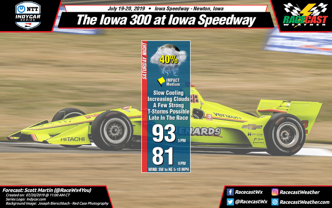
Skies will be partly cloudy to start but clouds will be on the increase throughout the evening as the cold front approaches. Temperatures at 5:00 pm will start off in the lower 90s and will slowly fall into the lower 80s by the end of the race. Rain chances will go up to around 40% as early as 8:00 pm and likely after 9:00 pm. Winds will start off out of the southwest at 5-10 MPH but will shift out of the northeast at 5-10 MPH.
At first, we'll have to deal with the oppressive heat as the afternoon high will top out at 93 degrees. Pair that with the dewpoint at 76 degrees, the heat index will be around 106 degrees. An Excessive Heat Warning is in effect for the area until 7:00 pm tonight.
After heat levels start to slowly decline, we'll have to turn our attention to the skies and to the radar as a cold front will be draped over Central Iowa during the evening. Convective showers and thunderstorms are expected to fire along and ahead of the front that will bring a chance of storms to the track mainly during the second half of the race. The good news is that the heavier activity should hold off until after the race is over, but any storms that do form could be strong.
Skies will be partly cloudy to start but clouds will be on the increase throughout the evening as the cold front approaches. Temperatures at 5:00 pm will start off in the lower 90s and will slowly fall into the lower 80s by the end of the race. Rain chances will go up to around 40% as early as 8:00 pm and likely after 9:00 pm. Winds will start off out of the southwest at 5-10 MPH but will shift out of the northeast at 5-10 MPH.
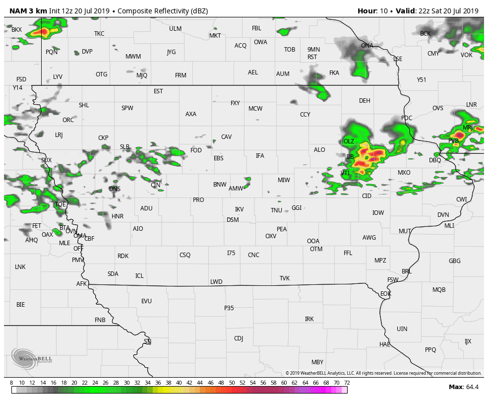
12z NAM-3k model valid from 5:00 pm to 10:00 pm Saturday.
The latest NAM-3k model run shows the potential for showers and thunderstorms developing throughout the evening that could affect Newton and Iowa Speedway at some point this evening. I actually believe that the rain coverage is actually being underdone with this run.
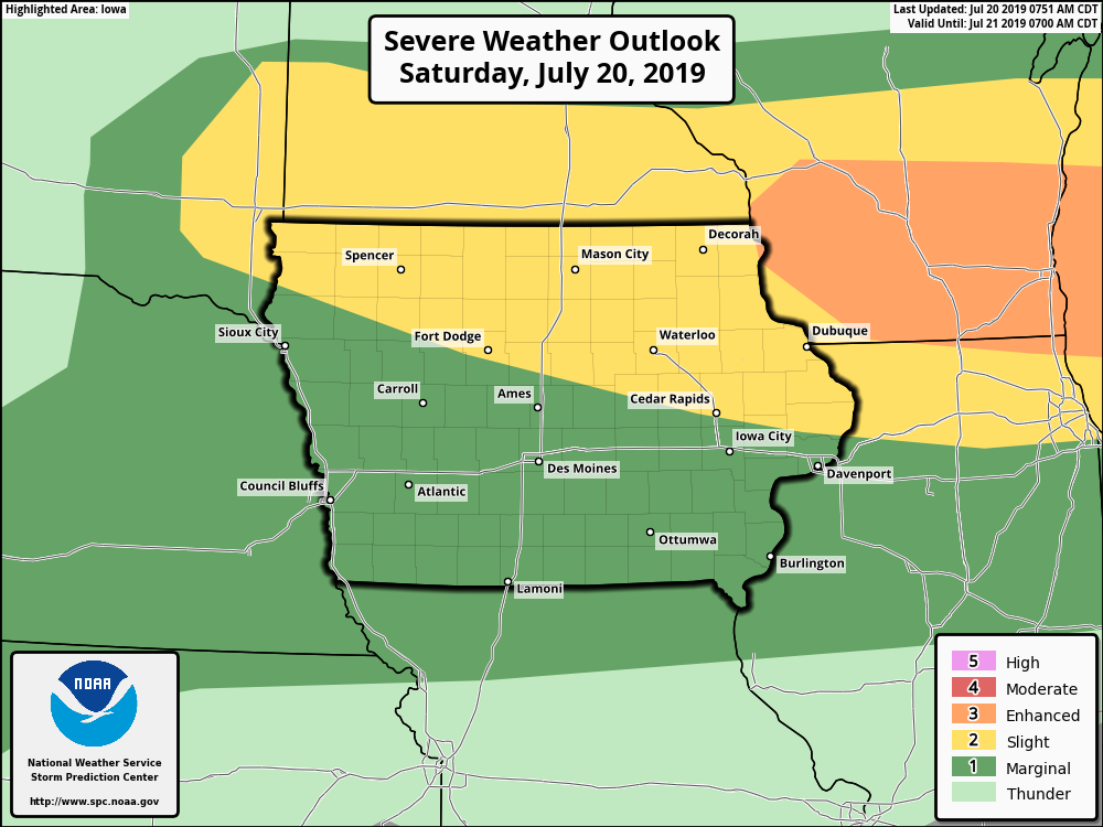
A few of those thunderstorms that develop this evening have the potential of becoming strong to severe. Iowa Speedway has been placed in a Marginal Risk for severe storms throughout the entire day and through the night time hours. Main threats will be from large hail and damaging winds up to 60 MPH, but there is a small threat of a tornado.
Bottom line for today: Be careful with the heat during the daylight hours. Hydrate often and stay out of the sun as much as possible. For the evening hours, stay weather aware. If the track issues a weather alert, follow the instructions that they give you.
Lightning will be the largest threat with these storms, so if you hear thunder, seek shelter immediately. Lightning can strike up to 10 miles away from the parent thunderstorm. If you can hear thunder, you are close enough to be struck.
Radar is up and is already pretty active well to the northwest of the area.


