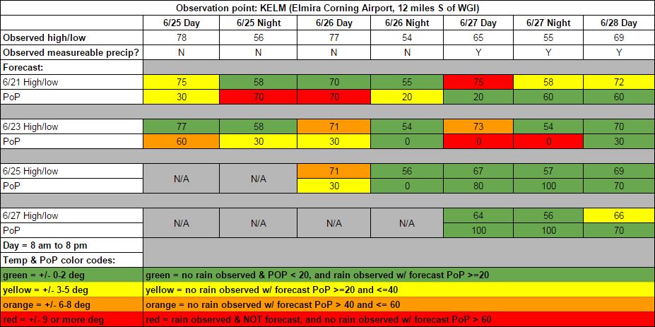
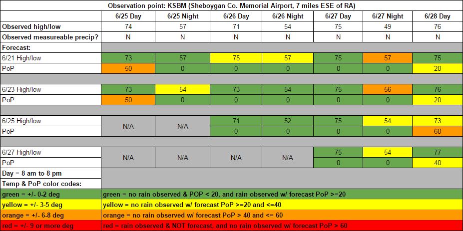
Let's take a look back at the good, the bad, and the ugly of my race forecasts from the past weekend at Watkins Glen and Road America.
My initial Sunday forecast called for a low pressure system to track across western New York over the weekend. I was confident that there would be rain, but I was uncertain about the timing of the best rain chances. This initial forecast wasn't too far off from what actually happened, but the problem was that I went the wrong direction with the Tuesday update. The models changed their tune and started to show a more southerly track of the low pressure center across northern Virginia and Maryland, keeping the rain south of the area. I bit on this change a little too hard, and took out all the rain chances from Saturday and Saturday night. In hindsight, I probably should have hedged my bets and left in at least a small chance of rain as the large scale pattern was still an active one. Sometimes it is best to focus on the larger pattern shown by the models rather than focus on the smaller details, which can often change drastically from one model run to the next.
Sure enough, the Wednesday model runs completely flip-flopped, and went back the their earlier track of the low across upstate New York. My Thursday morning update caught this, and ended up being accurate. I mentioned in my Thursday blog post that the heaviest rain would fall from late Saturday morning through Saturday night, with Sunday's rain being lighter and more on/off showers. My Saturday update expressed doubt that TUDOR qualifying would happen at all due to heavy rain expected around that time, and in fact it was canceled. The observed rainfall on Saturday and Saturday night was 1.86 inches at the airport, with 0.03 inches recorded on Sunday. Based on what I was seeing while watching the race, it looked like the track received more rain than that on Sunday, but as expected, it was definitely more on/off shower activity rather than Saturday's steady rain.
Rain showers were scattered around eastern Wisconsin on Thursday, but never hit the track or the airport. My temperature forecasts for Friday and Saturday were pretty much spot on. Saturday night ended up with fewer clouds than I had initially suspected, which resulted in cooler temperatures than forecast. A low pressure system dropping southeast out of central Canada brought some rain to Minnesota and western Wisconsin on Sunday. The rain got as far east as Fond du Lac, about 20 miles west of Road America, before it dissipated. I don't feel too bad about having a low to slight chance of rain mentioned in the forecast for Sunday since the rain did get fairly close, but I went too high with the 60% chance on the Thursday update. Aside from that Thursday update, Sunday's temperature forecasts were all within one degree of the observed high temperature.
We appreciate your feedback on our forecasts, both good and bad. Let us know what you think in the comments on this blog, on Twitter - @RacecastWx, @Race4caster, and @RaceWx4You - or on our Facebook page.


