An upper level longwave trough currently centered over eastern Mongolia and northeastern China will persist over the region in the coming week. Towards the end of the week, the trough will deepen slightly, extending southwestward as the trough itself moves east. Much of Japan will be downstream of the center of the trough, resulting in upper level winds being primarily from the southwest for the first part of the weekend. With winds from the southwest, moisture will move into the area in the upper levels from the East China Sea and the Philippine Sea. As the longwave trough moves past Japan on Friday, a shortwave trough is expected to develop behind the longwave trough and to the west of Japan. This shortwave trough will pass over early Sunday morning, where conditions will return to more zonal flow with upper level winds from the west.
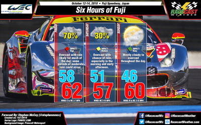
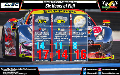
The aforementioned longwave trough will cause a surface low pressure system to develop over the Korean peninsula and the Sea of Japan around mid-week. As the trough moves eastward, the surface low is expected to move northeast towards the Sea of Okhotsk and eventually the North Pacific Ocean and an area of high pressure is expected to build in. With the high to the west of Japan and the low to the northeast, the area where the two systems meet will cause winds to propagate from the north to northwest, bringing cooler temperatures from northeast China and parts of Siberia. As the surface high continues to build in towards Japan, the winds are expected to shift more to the northeast during the day on Friday. These winds will bring moisture from the Sea of Japan to the region, resulting in a high chance for precipitation during the day.
On Saturday, a surface low pressure system could develop to the south of Japan ahead of the shortwave trough before moving eastward out to the Pacific Ocean. Depending on the location in relation to the southern coast, the system could bring more precipitation to the region as moisture would wrap around the low from the south and east. Should the low pressure system, winds would increase slightly, though they would continue from the northeast due to the area between the two systems being located over the region.
On Sunday, the return to zonal flow will result in upper level winds bringing drier air from the mainland. Moist air in the lower levels will cause some mostly cloudy to overcast skies throughout the day, but with drier air aloft, the chance of precipitation is minimal. With winds continuing from the north to northeast, temperatures will remain cool through the day.


