
By: Stephen McCoy

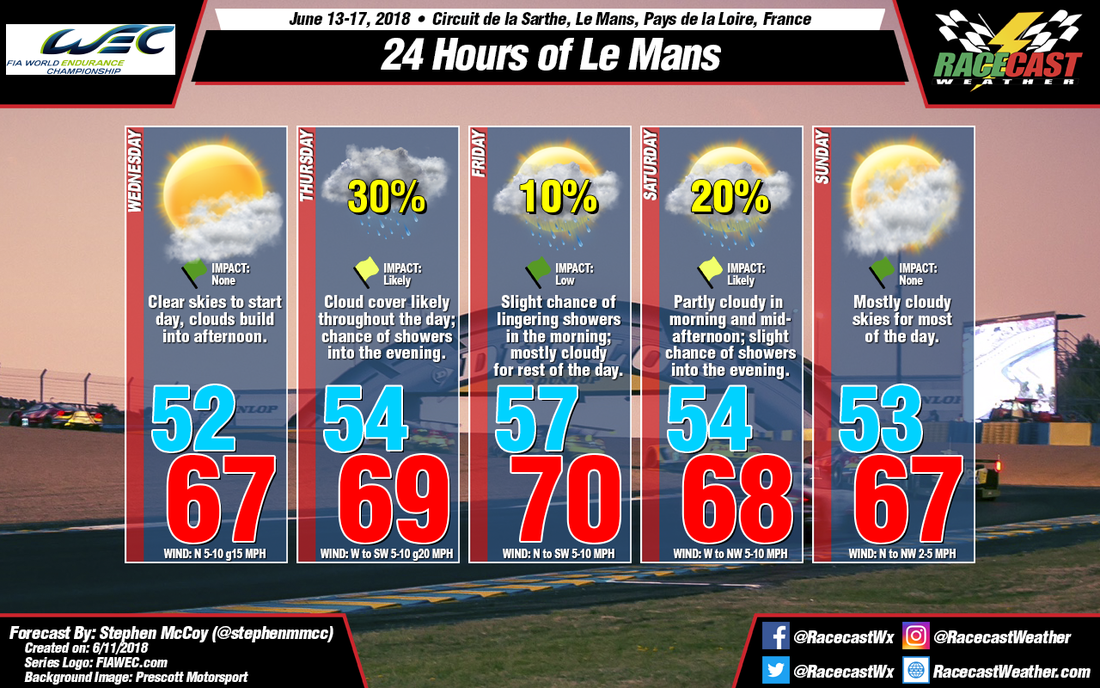
For Wednesday, winds in the upper and lower levels of the atmosphere and at the surface are expected out of the north. As the winds are vertically stacked through the atmosphere, some moderate wind gusts are likely. Partly cloudy skies should persist through the day as the winds will bring moisture off the North Atlantic Ocean and the English Channel.
A strong surface low pressure system located between Scotland and Iceland is expected to move towards the northeast past Scandinavia. A strong cold front will be associated with this system and will track over the United Kingdom and could extend into northern France in the early afternoon on Thursday. This will cause winds to shift from the north to the west to southwest, with some stronger gusts likely. With winds primarily out of the west from the North Atlantic Ocean in the upper and lower levels of the atmosphere, and lifting from the cold front, there is a chance of showers into the evening hours and overnight, likely impacting the 2nd and 3rd qualifying sessions for the 24 Hours.
Winds in the atmosphere will continue out of the west, though not as strong as on Thursday; surface winds will be variable through the day. A slight chance of showers is expected in the morning, as the mainly westerly flow will continue to bring moisture off the North Atlantic. As the day progresses, winds in the lower levels will shift towards the southwest. With the addition of daytime heating, precipitation chances will decrease and mostly cloudy skies will be expected for the remainder of the day.
For Saturday, conditions will start partly cloudy with variable winds at the surface and light winds from the west and southwest in the remainder of the atmosphere. As the day progresses, a shortwave trough in the upper atmosphere is expected to move through northern France; this will bring warmer, moist air into the area from the Bay of Biscay. With the addition of low level winds from the west to southwest, a slight chance of showers is expected in the afternoon to evening hours of the race. However, as the trough passes through the region overnight, winds in the upper levels will shift towards the north to northwest and as a result, precipitation chances will decrease into the morning on Sunday; mostly cloudy skies and light winds will persist throughout the remainder of the day.


