
By Scott Martin
Sorry for the delay in getting a forecast discussion out to you for the IMSA Sportscar Weekend at Road America. Unfortunately, the forecast for the fans at the track may be wet at times, as the weather pattern shows the potential for showers and thunderstorms to pass through at times throughout the weekend.
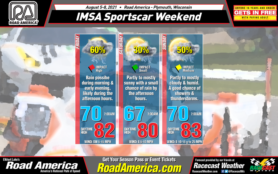
A surface low is located due north from the track over the Great Lakes that will slowly move eastward today, bringing with it a cold front that will move into the northern half of Wisconsin. Showers and storms will be possible early through the morning hours, with chances increasing during the main heating of the day for the afternoon hours, then decreasing chances when we reach the late afternoon to early evening hours. While it will not rain the entire time, rain could occur at any time. Otherwise, skies will be partly to mostly cloudy today, with highs reaching the lower 80s. The overall rain chance is 60%. Winds will be out of the southwest at 5-15 mph.
The cold front will continue to hang out over the middle of Wisconsin on Saturday, but the good news is that the weather will not be all that bad. We'll only have a small chance of a few showers or storms during the afternoon to early evening hours, only around 30%. Skies will be partly to mostly cloudy, with highs around 80 degrees. Winds will be out of the east at 5-10 mph.
Rain chances will rise once again on Sunday as another surface low will approach the area from the west and will stay west of the state, but it will pull more moisture up into the state. The cold front will be over the southern parts of Wisconsin, but it will start to push northward again as a warm front. Showers and storms will be possible throughout the day, but the greatest risk will be during the mid to late afternoon hours. Skies will be partly to mostly cloudy, with highs reaching the lower 80s. Winds will be out of the south at 5-15 mph, with the potential for gusts of 25 mph during the mid to late afternoon. Overall rain chances will max out at 50%.


