
By Scott Martin - @RaceWx4You
This weekend at the Indianapolis Motor Speedway for the 101st running of the Indy 500 is starting to get that "iffy" look to it. There will be a system moving through the area starting on Friday evening and will not leave until the late afternoon hours on Sunday. We should be able to get the race in on Sunday at full completion, but will we have some delays? That is the main question. Here is the forecast as of now...
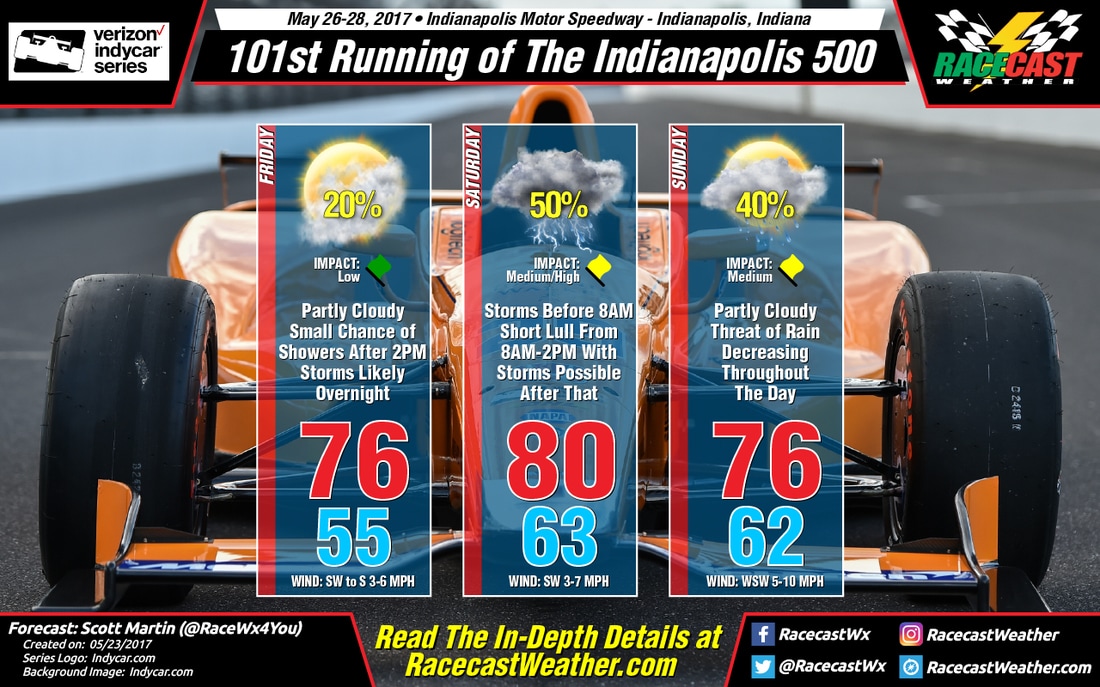
Friday
The day will start off with mostly clear skies, but clouds will be on the increase during the day. It will be dry during the morning and early afternoon hours, but the chances of an afternoon shower/storm rises to about 1 in 5 for the remainder of the daytime hours due to the approach of an upper wave. Good news is that if any rain occurs, the amounts will be very light, and delays will be short if any at all. Afternoon high will be around 76 degrees, and winds will be out of the southwest to the south at 3-6 MPH.
Saturday
That upper wave will have the possibility of bringing some strong storms to the area during the evening on Friday into the day on Saturday. An unstable airmass with the wave will allow for robust convection, and the highest threat for strong to severe storms will be across Central Indiana. There will be a wave of storms moving through before 8AM, then a lull in the action until the mid afternoon hours, and scattered storm development picks back up throughout the rest of the day. Too early to know what the strength or what threats will be, but Saturday needs to be a day to stay weather aware. The high will top out around 80 degrees. Rain chances are over 50% to start with, then drop to around 20% during the lull in action, and finish off near 50% for the late afternoon into the night time hours. Rain totals of 1/2 inch will be possible.
Sunday
As the wave moves through the area, rain and storm chances will begin to drop throughout the day. Skies will start off mostly cloudy, but will begin to clear out some as the afternoon progresses. The high should top out around 76 degrees, with winds out of the west-southwest at 5-10 MPH. Rain chances start off at 40% during the morning, and drops to around 30% by noon. Good news is that if any rain occurs, the amounts will be very light, and delays will be short if any at all.


