
By Doug Schneider
The week leading up to the Michelin GT Challenge events at VIR will have beautiful weather as high pressure settles over the eastern states from the surface through the midlevels of the atomsphere. As teams load into the track on Wednesday and Thursday, there will be plenty of sunshine, high temperatures in the mid to upper 80s, light winds, and low humidity.
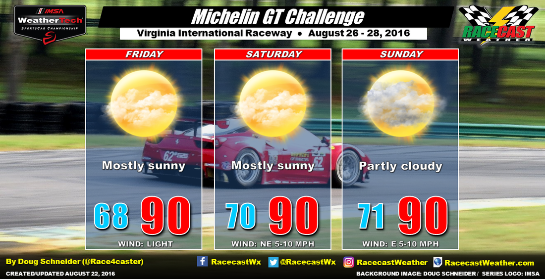
A cold front is expected to be located across the Ohio River and West Virginia by Friday morning, and push southeast through the day. It may produce some showers in the mountains, however, I don't expect it to have much impact at VIR for a couple reasons. First, it will have to cross the mountains, which tends to have a weakening effect in some situations. Second, there will be a large high pressure ridge in the midlevels of the atmosphere over the Carolinas that will also help to slow and weaken the front, and suppress any precipitation associated with it. With very little moisture available to work with and no upper level support, the front should be rain-free by the time it gets near the VA/NC border Friday night. The only effect from the front will be a shift of winds to the northeast on Saturday.
With the strong midlevel ridge centered over the Carolinas, temperatures will likely be warm and slightly above normal, with highs around 90. Humidity levels will gradually be rising through the weekend as there will be a little more moisture spreading into the area due to east winds off the Atlantic Ocean. The increasing moisture may also produce a little more cloud cover on Sunday. Will there be enough moisture to produce some isolated afternoon showers and thunderstorms? That is not completely out of the question for Sunday, but I think the chance of that happening looks low enough to keep any rain chance out of the forecast - less than 20%. There appear to be more factors going against rain on Sunday than for it, but I will be watching this closely over the next few days.


