
By Doug Schneider
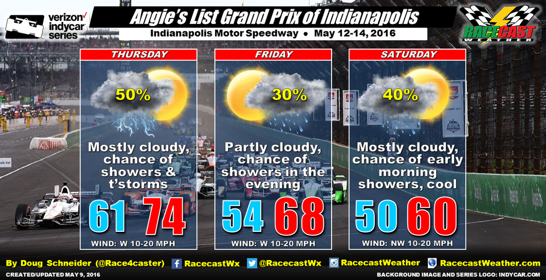
The weather pattern across Indiana for the later half of this week looks pretty active, featuring a couple of cold fronts and upper level disturbances moving across the area. The result will be some chances of rain each day during the Grand Prix of Indianapolis, but the key to whether it will affect the on-track action will be the timing, of which there remains some uncertainty.
The first cold front is expected to move through Indiana on Thursday. There are some timing differences among the various models, with some showing most of the rain in the morning, and others showing the better chances in the afternoon. I think there will be two periods of rain on Thursday - one in the morning with an upper level disturbance moving through, then another late in the day or evening with the surface cold front passage. If this happens, there could be a dry period in the middle of the day that will allow for most of the practice sessions to stay dry. Thursday will be the warmest day, with highs reaching the mid 70s.
Most of the day on Friday is expected to be dry behind the exiting cold front, and temperatures will be getting cooler. But there will be another low pressure system and cold front approaching the area. Again, the timing is still uncertain, but at this time it appears that the precipitation will hold off until Friday evening, with most of it coming Friday night. I expect that the cold front to move through Indianapolis on Saturday morning, taking the rain with it. So the 40% chance of rain that I have for Saturday is mainly for the early morning hours, and I expect that the race in the afternoon will be dry. But with another shot of cold air behind the cold front, temperatures during the race will be struggling to reach 60 degrees. With this active weather pattern, each day will have winds of 10 to 20 mph.
Look for updates through the week by following our social media feeds on the right.


