
By Doug Schneider
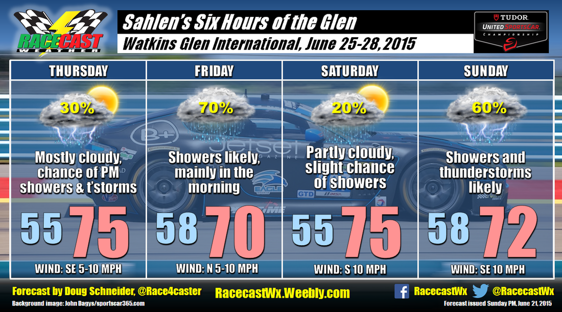
The weather pattern looks like an active one later this week across the northeast, which could make for a wet weekend at Watkins Glen. At the moment, it looks like there will be two main periods of rain that are likely to affect activities - Thursday night into Friday, then Saturday night and Sunday. I have been watching the trend of the weather models for the past few days, and although they are coming into better agreement today, there are still some important differences that add uncertainty to the forecast. I'd put my confidence in this forecast right now at medium.
A low pressure system is expected to track across northern Ohio and Pennsylvania Thursday night into Friday morning. Some showers and thunderstorms could develop ahead of the system as early as Thursday afternoon, but the majority of the rain will arrive after sunset. Rain appears likely Friday morning, with decreasing chances of rain through the late morning and early afternoon.
High pressure builds in briefly on Friday night and Saturday, which should provide a mostly dry day. However, I am mentioning a slight chance of showers due to uncertainty about the timing of the next system. The models agree that a low pressure system will track from central Indiana to western New York, but their timing is different. The GFS is the faster of the models, and brings rain in as early as Saturday afternoon. I prefer the slower timing of the ECMWF model a little more, which holds off the rain until Saturday night. Again, the timing differences will have a big impact on Sunday. A faster movement of the system will bring most of the rain Saturday night and Sunday morning, with drying coming in the afternoon. My forecast reflects my preference for the slower model, which has most of the rain occurring through the day on Sunday. The reason for my preference is that the slower ECMWF model has shown better consistency over the past few days, while the GFS has been having more run-to-run changes, and has been trending more toward the ECMWF.
We'll see how things change (and they surely will) as we go through the week. For Twitter updates, follow @Race4caster. Our live radar link is up and ready to go at the top of the website.


