
By Scott Martin
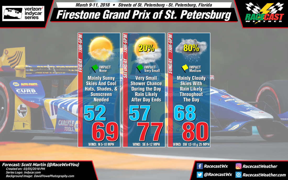 |  |
Friday's weather in St. Petersburg will be really nice for getting out on the track, but conditions will be different from what you will experience on Saturday and Sunday. After starting off really cool in the lower 50s at 7AM, temperatures will climb nicely throughout the morning and early afternoon hours under mainly clear skies. Afternoon highs will top out in the upper 60s, around 69 degrees. Winds will be mainly out of the north at 5-10 MPH.
Saturday's weather will actually be nicer, with warmer temperatures and a cloud or two to offer some shade at times. A center of low pressure will be entering the southeastern U.S., causing winds to be out of the southeast at 8-12 MPH throughout the day. The good news is that it looks like nearly all of the rainfall will hold off until well after the track activity is over for the day, but I cannot rule out a very small chance of a stray shower moving through at some point during the afternoon hours. Afternoon highs will end up in the upper 70s, around 77 degrees, after starting off in the upper 50s at 7AM. Rain is expected to move in during the late night hours.
Saturday's weather will actually be nicer, with warmer temperatures and a cloud or two to offer some shade at times. A center of low pressure will be entering the southeastern U.S., causing winds to be out of the southeast at 8-12 MPH throughout the day. The good news is that it looks like nearly all of the rainfall will hold off until well after the track activity is over for the day, but I cannot rule out a very small chance of a stray shower moving through at some point during the afternoon hours. Afternoon highs will end up in the upper 70s, around 77 degrees, after starting off in the upper 50s at 7AM. Rain is expected to move in during the late night hours.
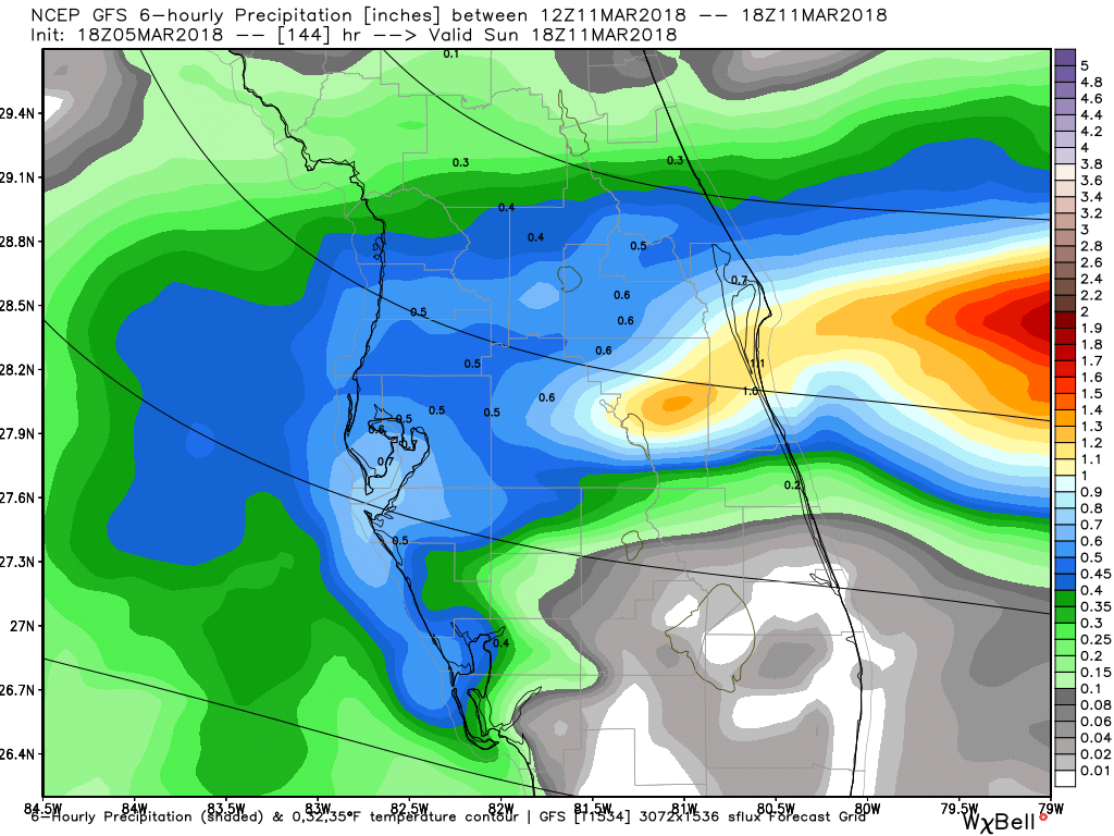 GFS 6-hour precipitation valid from 6AM-12PM Sunday. | 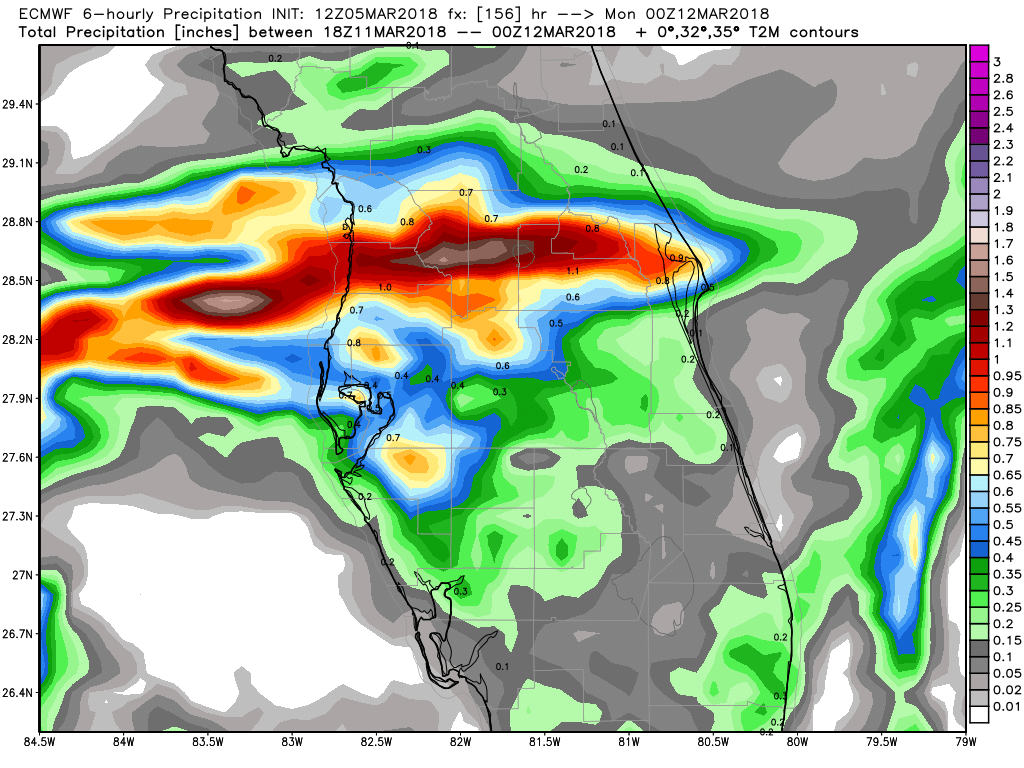 ECMWF 6-hour precipitation valid from 12PM-6PM Sunday. |
Sunday will be wet at times, but the exact timing of the heavier activity is questionable at this point. The GFS model is showing the heaviest activity moving through the area between 6AM-12PM, with rain moving out of the area soon after. The ECMWF keeps rainfall very light and scattered in nature throughout the same time frame, but brings in the heavier precipitation between 12PM-6PM. The good news, at this point, lightning does not appear to be likely, but rainfall could be heavy at times. The ECMWF is painting just over 0.75 inches of rain on Sunday, while the GFS shows over 2 inches.
It is too early to know for sure what exactly will happen, but I'll have a better idea as we get closer to the weekend. My official forecast at this point will be cloudy skies with rain likely at anytime throughout the day. Rainfall could be heavy at times, and winds will be out of the southwest at 12-18 MPH with gusts up to 25 MPH possible. Afternoon highs may reach 80 degrees, but that is questionable depending on when the main bulk of the rain arrives in the area and how strong the southwesterly flow over the area is. 7AM temperatures will be in the upper 60s, around 68 degrees. Rain chance is set at 80%, but that could be bumped in any direction when the forecast changes.
Needless to say, rain tires (or tyres) will be likely on Sunday, but can we keep the rain from getting too heavy to prevent the cars from racing. I'll have your forecast updates throughout the week, and radar will be up and running on Friday. Have a great day and a great week!


