
By Doug Schneider
The excitement builds this week for the 100th Indianapolis 500 as we head toward qualifying. For this week's practice sessions, it looks like Tuesday will have the greatest threat of rain. A front will be draped east to west across Kentucky on Tuesday, and moisture riding up and over that front will lead to periods of showers during the day. I expect that there won't be much on track action on Tuesday. However, Wednesday and Thursday look nice, with a good amount of sunshine both days, and high temperatures between 65 and 70.
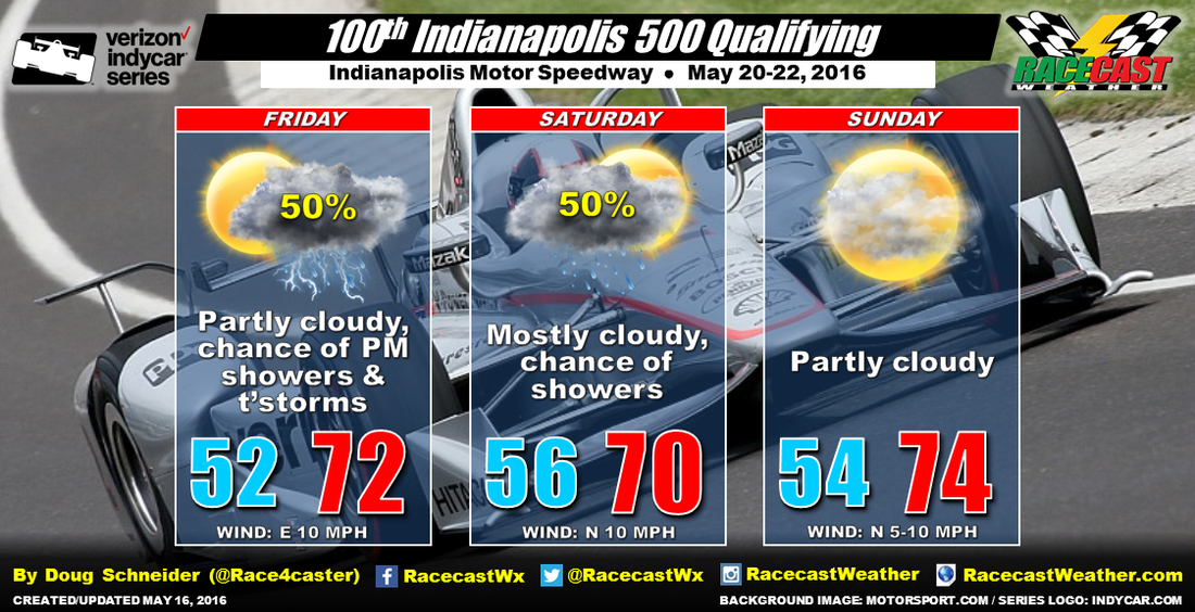
A low pressure system will be tracking from the southern Plains to the Ohio Valley later this week, which will bring a chance of rain back into the forecast for Friday and Saturday. The models are in general agreement about this, although there are some differences in timing of the end of the rain chances. As it stands right now, it looks like rain will start to move into the area on Friday afternoon. The best chances of rain appear to be Friday night, as the center of the low pressure tracks northeast along the Ohio River. The end of the rain is uncertain at this time, because one model (ECMWF) holds the upper trough over Indiana and Ohio through the day Saturday and even into Sunday, while another (GFS) has a more progressive upper trough that takes all the rain to the east by Saturday morning. With this uncertainty, I will have a 50% chance of rain on Saturday.
I'm going to go with a dry forecast for Sunday, with the expectation that the system will track far enough east by then to take the rain and most of the clouds out of Indiana. But I will qualify that (no pun intended) by saying that there could end up being a chance of rain Sunday if the slower of the models turns out to be correct. The cars will have a little bit of a tailwind on the front stretch both Saturday and Sunday, with winds from the north at 5 to 10 mph.
Check back here and on our social media feeds on the right for forecast updates through the week.


