
By Doug Schneider
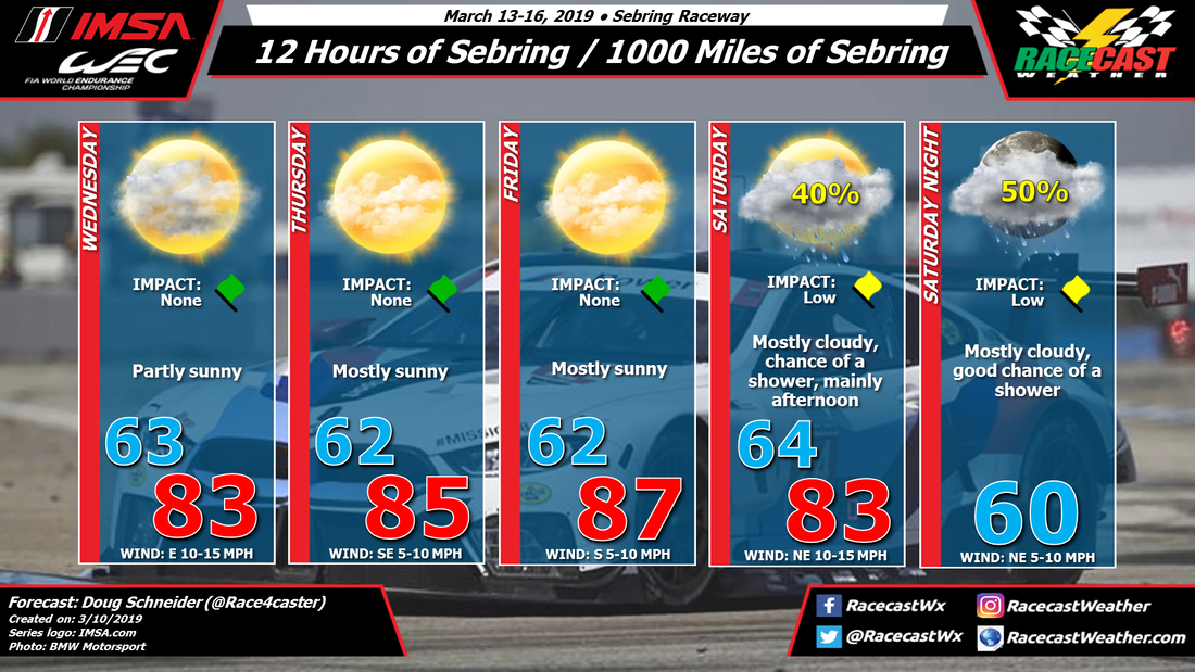
#SuperSebring weekend should be an awesome event as IMSA and WEC join up at the classic track. It looks like the weather will cooperate for most of the event, but it is possible that the 12 Hours on Saturday could see some light rain.
A large high pressure area at the surface will be over the southeast as the event opens on Wednesday. In the upper levels there will be a high pressure ridge extending from the Caribbean across Florida and along the U.S. coastline. The surface high and the upper ridge will gradually shift eastward through Thursday and Friday. This pattern will provide sunny and warm conditions each day, with highs in the mid to upper 80s F, or upper 20s to lower 30s C.
The eastward shift of the high and ridge will allow for increasing moisture and a cold front to move into Florida from the northwest on Saturday. As this front pushes south, it will help generate some scattered showers around the Sebring area. Timing of showers is uncertain this far out, but the afternoon hours appear more likely to have a chance of rain than the morning. The front is expected to be south of the track in the afternoon, which will shift winds to a northeasterly direction. Moisture aloft will continue to ride up and over this front Saturday night, and may keep some showers in the area.
The good news is that this does not appear anything like what we saw at Daytona. The shower coverage is expected to be more scattered rather than a constant rain, and it does not look like heavy rain will occur. Things can certainly change this far out, but I have been watching the models for several days now, and they have not changed much from one run to the next. This gives me more confidence that this forecast will generally hold up through the week.


