
By Doug Schneider
A cold front is expected to bring some showers and thunderstorms to the Virginia/North Carolina border region on Thursday, but there is a lot of uncertainty about what happens after Thursday as the models do not agree on where the front will be located as on-track activities begin at VIR.
The chance of rain at VIR is highest on Thursday as a cold front approaches from the north. Showers and thunderstorms are likely Thursday afternoon, with the chance of rain around 60%.
There are a couple different scenarios about how fast this front will move through southern Virginia, which makes this forecast uncertain. The GFS model is quick to push the front through and bring in dry air behind it. It shows the front moving south of VIR on Thursday night, and brings in cooler and drier air on Friday. This scenario would keep Friday through Sunday rain-free.
The ECMWF (Euro) model is much slower with the southward movement of the front. It does not take it south of VIR until late Friday night or Saturday morning. This scenario would keep a chance of rain going through Friday and into Saturday.
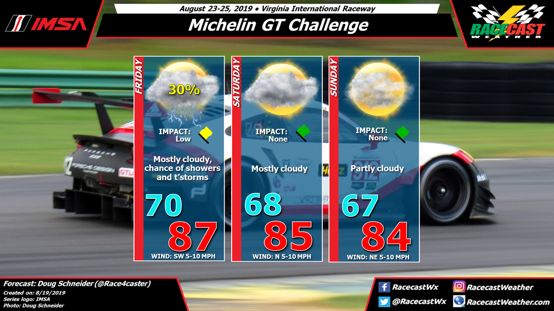
With such as big timing difference, my forecast confidence is low, but I'm going to take a middle-of-the-road approach. I think the front will be close enough to VIR to warrant a chance of showers and thunderstorms on Friday, then move far enough south to keep rain out of the forecast for Saturday.
The good news in this forecast is that the main event on Sunday is likely to be dry. Since the models are in agreement for that day, my confidence in Sunday staying dry is moderate to high.
Temperatures and humidity levels should drop a little behind the front, and with partial cloud cover and a northeast wind, Saturday and Sunday should be pleasant days to spend at the track with highs in the mid 80s. Not bad for late August in southern Virginia.
I'll be at the track so I'm really hoping the dry scenario works out. Check back through the week for updates.
The chance of rain at VIR is highest on Thursday as a cold front approaches from the north. Showers and thunderstorms are likely Thursday afternoon, with the chance of rain around 60%.
There are a couple different scenarios about how fast this front will move through southern Virginia, which makes this forecast uncertain. The GFS model is quick to push the front through and bring in dry air behind it. It shows the front moving south of VIR on Thursday night, and brings in cooler and drier air on Friday. This scenario would keep Friday through Sunday rain-free.
The ECMWF (Euro) model is much slower with the southward movement of the front. It does not take it south of VIR until late Friday night or Saturday morning. This scenario would keep a chance of rain going through Friday and into Saturday.
With such as big timing difference, my forecast confidence is low, but I'm going to take a middle-of-the-road approach. I think the front will be close enough to VIR to warrant a chance of showers and thunderstorms on Friday, then move far enough south to keep rain out of the forecast for Saturday.
The good news in this forecast is that the main event on Sunday is likely to be dry. Since the models are in agreement for that day, my confidence in Sunday staying dry is moderate to high.
Temperatures and humidity levels should drop a little behind the front, and with partial cloud cover and a northeast wind, Saturday and Sunday should be pleasant days to spend at the track with highs in the mid 80s. Not bad for late August in southern Virginia.
I'll be at the track so I'm really hoping the dry scenario works out. Check back through the week for updates.


