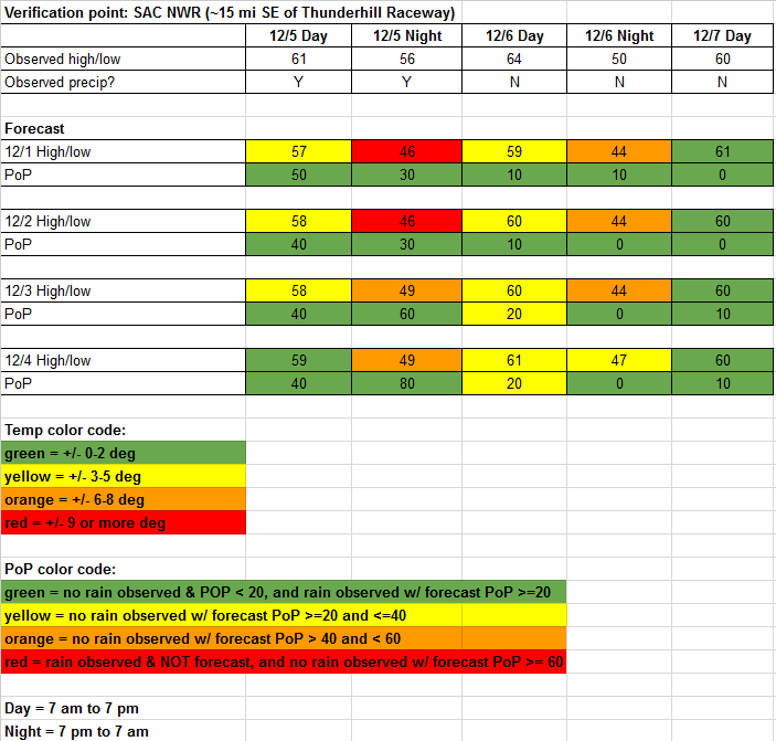
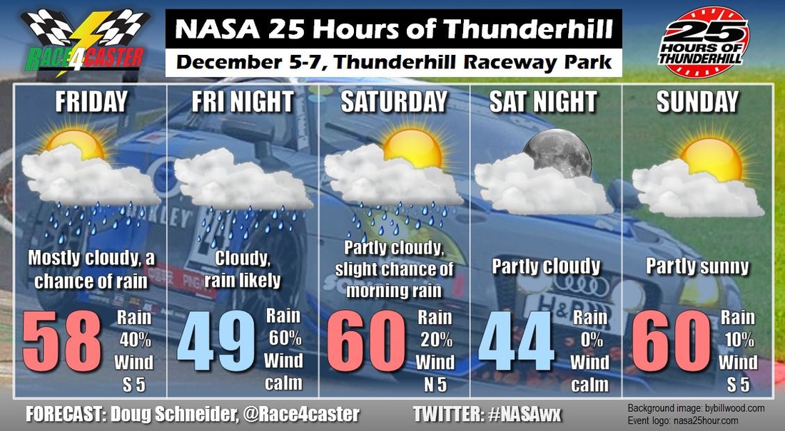
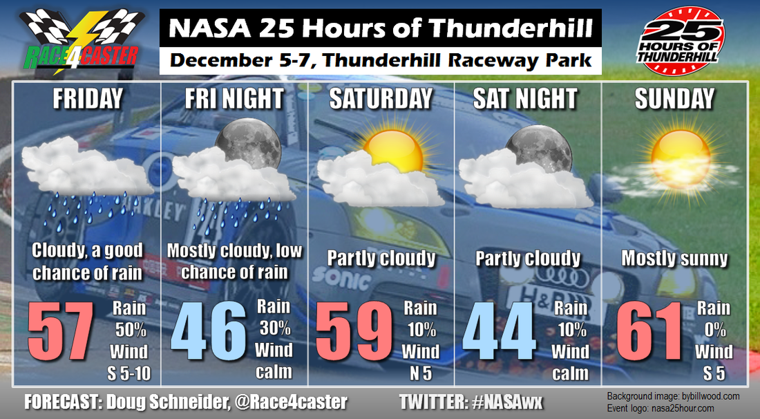
There are indications that a low pressure system could develop off the Atlantic coast and move into North Carolina Sunday night and Monday. I am skeptical of this system even developing as models tend to do poorly with tropical low pressure development this far out in time, and even if it does develop, it may arrive after the racing is over. But it is something I will be keeping an eye on over the next few days. Stay tuned to my Twitter feed @Race4caster for updates through the week.
By Doug Schneider 
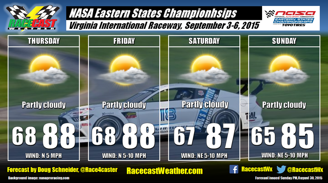
Virginia International Raceway hosts the NASA Eastern States Championships this coming weekend. The general weather pattern over the eastern states will feature high pressure over the Ohio Valley region on Thursday that will drift east to the Mid-Atlantic coast by Sunday. This high pressure ridge will likely have a stabilizing effect on the atmosphere, and so I am not mentioning a chance of rain in the forecast at this time. While afternoon showers could pop up, I think the chances of one at the track are too low to mention a chance of rain. The main weather concern will likely be the heat and humidity. It will be warm each day, with highs in the upper 80s, and it will feel humid, with afternoon dewpoints in the mid to upper 60s.
There are indications that a low pressure system could develop off the Atlantic coast and move into North Carolina Sunday night and Monday. I am skeptical of this system even developing as models tend to do poorly with tropical low pressure development this far out in time, and even if it does develop, it may arrive after the racing is over. But it is something I will be keeping an eye on over the next few days. Stay tuned to my Twitter feed @Race4caster for updates through the week. By Doug Schneider There will be very little change to the weather pattern through the weekend across the central California coastal area, so each day of the NASA Western States Championships at Mazda Raceway Laguna Seca should see similar weather to the day before. A west-northwest flow off the ocean will result in low clouds to the area each morning - the combination of the low level moisture from the ocean and cooling temperatures at night cause water vapor to condense into clouds. But as the summer sun rises and causes mixing of the lower levels of the atmosphere, the clouds will dissipate, leaving mostly sunny skies in the afternoon. No rain is expected as the moisture off the ocean will be confined to a very shallow layer. Temperatures will be really nice throughout the event, with highs each day in the lower 70s.
By Doug Schneider There's not too much change to the forecast with today's update for the NASA Western States Championships. It does look like there will be some moisture that will spread northward toward the Monterey Peninsula, and this will bring some clouds on Friday and early Saturday morning. Some models are hinting at some light rain on Friday with this moisture, but I really doubt that it will be enough to squeeze out any measurable precipitation. I'm sticking with a dry forecast. Clouds may linger into Saturday morning, but most of the day should be sunny. Sunday will see plenty of sunshine as well, and temperatures each day will top out the mid 70s.
By Doug Schneider I have to make a confession - I really dislike forecasting for California. Part of the enjoyment of meteorology is to analyze the weather pattern and try to figure out the most likely scenario that will occur. In California, that scenario is almost always dry and sunny. I should probably be grateful that I have a high probability of making an accurate forecast, but honestly, it's boring. But at least it's great weather for racing!
A big ol' high pressure ridge will be over the western United States next weekend, which will provide nice weather for the NASA Western States Championships. The pattern remains the same for several days in a row, so I don't see much change happening from one day to the next. Every day will be mostly sunny with highs in the mid 70s. At Laguna Seca, there's always some potential for morning fog. It's too early to make a call on that, but I'll keep an eye on it as we approach the weekend, and update the forecast as needed. By Scott Martin Here is the latest forecast as of 8:30 AM EDT on Thursday 3/26/15:
THURSDAY Partly cloudy skies expected throughout the daytime hours, with a slight chance of a passing shower during the late morning through the late afternoon hours. More clouds move in for the evening and overnight hours with a slight chance of rain and an isolated thunderstorm. HIGH: Lower 80s LOW: Around 70 WIND: SW 5-15 MPH CHANCE OF RAIN: 20% FRIDAY Mostly cloudy to completely cloudy skies throughout the daytime hours, with rain and some imbedded thunderstorms likely. Rain totals for the area are expected to be in the neighborhood of 1/2 to 3/4 of an inch. Winds will start to build throughout the day. Expect gusts up to 25 MPH after 12PM. Winds will shift from out of the southwest to northwest after 3PM. Rain chances start to diminish during the late evening and are completely gone after 2AM. Remember, if you hear thunder, seek shelter. Stay weather aware. HIGH: Middle 70s LOW: Around 60 WIND: SW Shifting To NW 10-20 MPH CHANCE OF RAIN: 70% SATURDAY Skies clear out and you will notice that the temperatures will definitely be cooler than the previous days. Expecting sunny skies with a little bit of a breeze. For the night time, much of the same. Clear skies and cooler. HIGH: Middle 60s LOW: Middle 50s WIND: NNW 10-15 MPH CHANCE OF RAIN: 0% SUNDAY Appears to be an almost carbon copy of Saturday, except it will be a little warmer. Sunny skies and not as breezy. HIGH: Around 70 WIND: NE 5-10 MPH CHANCE OF RAIN: 0% Be sure to follow Racecast Weather on our Twitter feed @RacecastWx, and like our Facebook page RacecastWx. Want to see live radar for the St Petersburg area, click on the Radar link at the top of this page. We are also featured on the Pirelli World challenge Series website at world-challenge.com. Click on the Weather link at the top-right of the page. by Doug Schneider (@Race4caster) Any meteorologist who takes his job seriously will check his forecast against what actually happened. Experience is the best teacher. Verification is how we learn what went wrong, what went well, and how we can do better. Scott and I want to be open about our forecasts, and show you how we're doing. At regular intervals through the race season, we'll post a summary of how our forecasts have verified.
A few points of note: PoP is probability of precipitation, or the percent chance of rain that is forecast. For more on what that means, see this post. Since most race tracks don't have any weather instrumentation that is publicly available, we have to use the nearest available weather station, usually a nearby airport. This is the "verification point", named by its three-letter identifier. In this case, SAC NWR is a weather station located about 15 miles SE of Thunderhill Raceway. There may be times when the observations at the verification point differ from the track, but the difference should not be significant most of the time. We verify precipitation based only on if measurable rain fell at the observation site, and not based on how much rain fell. Thus, the "observed precip" row will either be Yes or No. The rainfall forecast was pretty much right on the money for the 25 Hours of Thunderhill. I had the chance of rain in the right time periods with my initial forecast, and I correctly raised the PoP forecast for Friday night as it approached. In a tweet, I said rain would begin to move in between 4 and 6 pm, and it began around 5:30 pm. 0.17 inches of rain was recorded, which was a little below the range that I had forecast in a tweet (0.25-0.5). The entire race was dry, as I had forecast from the beginning. The temperature forecast was good each day, but off at night. Temperatures did not drop nearly as much as I expected. Probably my biggest forecast error, and one that does not show up in this spreadsheet, was wind. Observed wind speeds on Friday were 10-15 mph, and 15-20 mph with gusts to 25 mph Friday night. I had forecast 5-10 mph winds during these periods. The higher-than-expected winds may explain why the low temperature forecasts were off. Higher winds at night create more mixing of the air near the surface, which prevents cold air from settling at the ground. Since rain is probably the most important part of the forecast to most people at a race, I'm pleased with how my forecast verified. by Doug Schneider (@Race4caster) Rain chances will be increasing through the day on Friday, and there could be some light rain around for qualifying Friday afternoon. Rain is likely by Friday night, with about 0.25 to 0.5 inches of rain expected overnight. Most of the rain should end early Saturday morning, but there could be a little that lingers past sunrise. However, I'm confident that it will end in time for the start of the race at 11 AM. The rest of the 25 Hours looks dry, with some periods of clouds now and then.
by Doug Schneider (@Race4caster) The week leading up to the NASA 25 Hours of Thunderhill will be very wet, but it is expected that the rain will end in time for the race on Saturday and Sunday. Practice sessions on Thursday are likely to see some rain, and there's a good chance of seeing rain on Friday for qualifying. The timing of rain should come into better focus over the next few days. The upper level trough that is responsible for the rain will exit Friday night, which should leave nice weather for the entire race.
|
Social Feeds
Authors
Doug Schneider Partners
Categories
All
Archives
December 2023
|