
By Doug Schneider
I'm very excited about the Michelin GT Challenge next weekend, as I'll be at the race, providing weather information and consulting to track officials. I've been watching the weather closely for next weekend, so I figured I'd make a post to share what I've been seeing. There has been relatively good model agreement on the general weather pattern for next weekend, but this far out, the finer details remain hazy.
I'm very excited about the Michelin GT Challenge next weekend, as I'll be at the race, providing weather information and consulting to track officials. I've been watching the weather closely for next weekend, so I figured I'd make a post to share what I've been seeing. There has been relatively good model agreement on the general weather pattern for next weekend, but this far out, the finer details remain hazy.
VIR will have beautiful weather for the first half of the week. A cold front will move through on Sunday night, and behind it, cooler and less humid air will build into the area. With mostly sunny skies, high temperatures will be in the lower to middle 80s for Monday through Thursday. With dewpoints only in the mid 50s to mid 60s, humidity levels will feel quite comfortable.
Late in the week, a cold front will be approaching from the west, and will be located near the Appalachian Mountains on Friday. This front will be the main player in the weather for VIR over the weekend. The question will be how far south and east this front can push, and how much precipitation will form along it. Here's a sequence of maps that show where the front might be positioned on Friday, Saturday, and Sunday:
Late in the week, a cold front will be approaching from the west, and will be located near the Appalachian Mountains on Friday. This front will be the main player in the weather for VIR over the weekend. The question will be how far south and east this front can push, and how much precipitation will form along it. Here's a sequence of maps that show where the front might be positioned on Friday, Saturday, and Sunday:
As you can see in those images, I expect that the front will not make it through VIR, and that it will stall to the north and west before lifting back to the north as a warm front. Here's why I expect this -
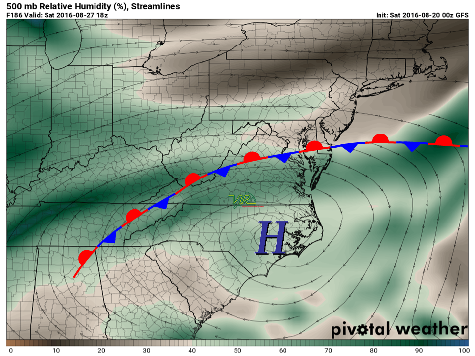
This map shows the circulation of winds in the mid-levels of the atmosphere on Saturday (it doesn't move much by Sunday). There will be a large high pressure area over North Carolina over the weekend, and with winds rotating clockwise around the high, I expect that this high will act like a barrier to prevent the front from pushing farther south. This should keep most of the shower and thunderstorm activity associated with the front near the mountains.
The position of that high will probably bring some warmer and more humid air for the weekend (compared to earlier in the week), with highs in the upper 80s, and dewpoints in the upper 60s to lower 70s.
A couple of caveats:
1) There may still be enough instability to the south of the front for isolated to scattered showers and thunderstorms in the Piedmont region on Saturday and Sunday, even if the front stays well north. However, models do not do well with forecasting instability levels this far out in time. So although the probability of rain at the track is low at this time, it is still a possibility.
2) Only a slight shift in where the front is located might make a big difference. If the mid-level high is weaker and the front stalls across southern Virginia, the potential for rain will be higher.
Taking these factors into account, I'd put the chance of rain right now between 10% and 30% both days.


