
, By Doug Schneider (@Race4caster)
The opening race of the IndyCar season is almost here. After an off-season that seems like an eternity, we are pumped for the season to begin. So let's take an early look at what the weather might be next weekend in St. Petersburg, Florida.
With all long-range forecasts (generally > one week), there are caveats. At this point, we can make general statements about what the weather pattern might be, but specifics on timing are evolving and are difficult to pin down at this time. The forecast is bound to change over the next week, so be sure to check here for updates and more detailed forecasts.
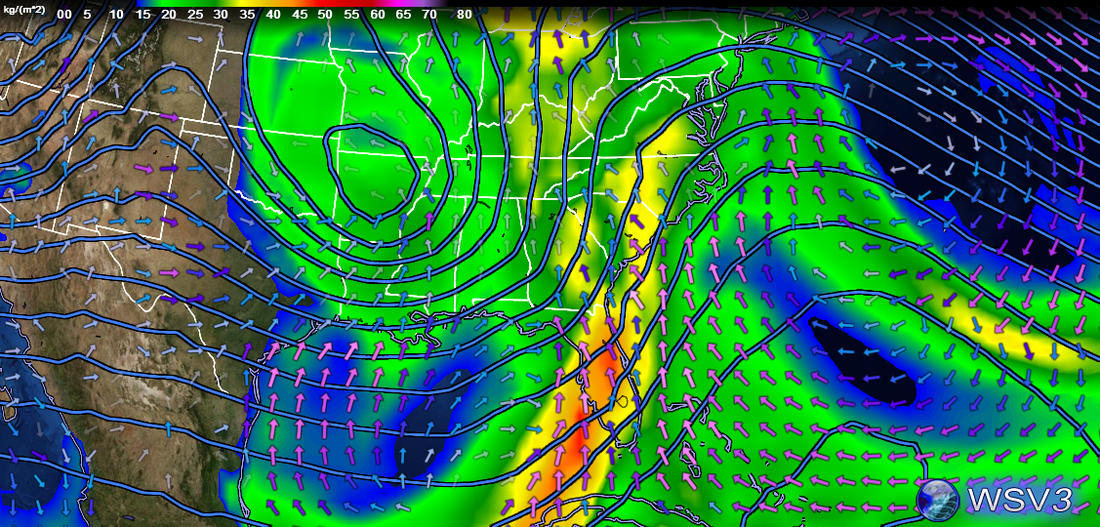
The general pattern over the southeast United States by Thursday will be a high pressure ridge over the Bahamas, and a low pressure system over Texas. Both the high pressure ridge and low pressure trough are highly amplified, or in other words, the trough is deep and the ridge is tall. This means that the pattern will be slow to evolve over the weekend. The image below is a model projection (GFS, 06Z 3/4 run) of pressure contours, precipitable water or moisture content (image), and surface winds at 7 AM Friday 3/11. There's a strong front over the Gulf of Mexico that is moving slowly east, located where moisture is high and the wind arrows are merging. The southerly flow over Florida ahead of the front should provide warm temperatures Thursday and Friday, with highs around 80 degrees both days.
The opening race of the IndyCar season is almost here. After an off-season that seems like an eternity, we are pumped for the season to begin. So let's take an early look at what the weather might be next weekend in St. Petersburg, Florida.
With all long-range forecasts (generally > one week), there are caveats. At this point, we can make general statements about what the weather pattern might be, but specifics on timing are evolving and are difficult to pin down at this time. The forecast is bound to change over the next week, so be sure to check here for updates and more detailed forecasts.
The general pattern over the southeast United States by Thursday will be a high pressure ridge over the Bahamas, and a low pressure system over Texas. Both the high pressure ridge and low pressure trough are highly amplified, or in other words, the trough is deep and the ridge is tall. This means that the pattern will be slow to evolve over the weekend. The image below is a model projection (GFS, 06Z 3/4 run) of pressure contours, precipitable water or moisture content (image), and surface winds at 7 AM Friday 3/11. There's a strong front over the Gulf of Mexico that is moving slowly east, located where moisture is high and the wind arrows are merging. The southerly flow over Florida ahead of the front should provide warm temperatures Thursday and Friday, with highs around 80 degrees both days.

By Saturday morning, that front will have moved closer to the St. Petersburg area. The image below is at 7 AM Saturday morning.
Of course, timing is everything, and that is where the uncertainty lies. I've been watching this pattern in the models that past few days and how they have been changing, and the trend of the models has been toward a slower movement of the system, and a later arrival time of precipitation in the St. Pete area. So while the current run of the GFS model (06Z 3/4) shows showers arriving Friday night and Saturday morning, later model runs will likely shift the timing, possibly later if the trend continues. But we can probably say with a reasonable amount of confidence that there will some some showers and thunderstorms in the area sometime over the weekend. One thing that gives me more confidence is that another model, the ECMWF, is generally in agreement with the GFS on this general pattern, but with some timing differences. With the front moving through over the weekend, temperatures on Saturday and Sunday will likely get cooler, with highs somewhere around 70 degrees.
I'll have a post with a more detailed forecast up on either Sunday evening or Monday morning.
UPDATE: Just to show you how quickly things can change regarding the timing of rain - the latest run of the GFS (12Z 3/4) is now showing the showers and thunderstorms moving through St. Pete on Friday afternoon/evening, So like I said, the timing is very, very subject to change. Stay tuned.


