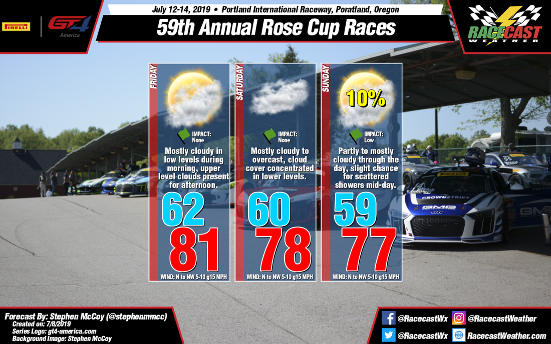
By: Stephen McCoy
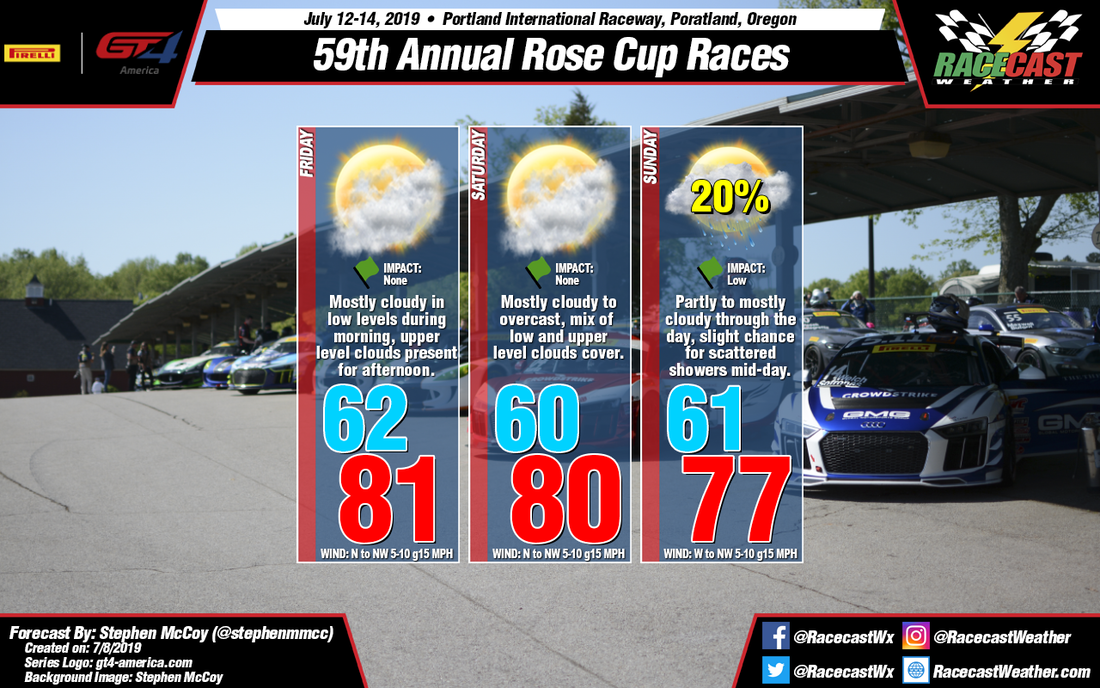
Conditions remain mostly unchanged for this weekend's Rose Cup Races at Portland International Raceway. The atmospheric set-up remains consistent with the initial forecast for the most part. However, the ECWMF has followed the GFS in showing winds more from the west on Sunday which will bring a slight chance for scattered showers near mid-day to the afternoon as moisture moves into the region from the Pacific; dry air in the mid levels will keep any convective precipitation from occurring. This is primarily due to the latest model output bringing the surface low pressure system mentioned below closer towards the coast which will then have a larger influence on the surface and low level wind direction than the surface high pressure system. Otherwise, conditions remain mostly identical, especially on Friday and Saturday; the atmospheric set-up is unchanged and can be found in the next paragraph, copied over from the initial forecast.
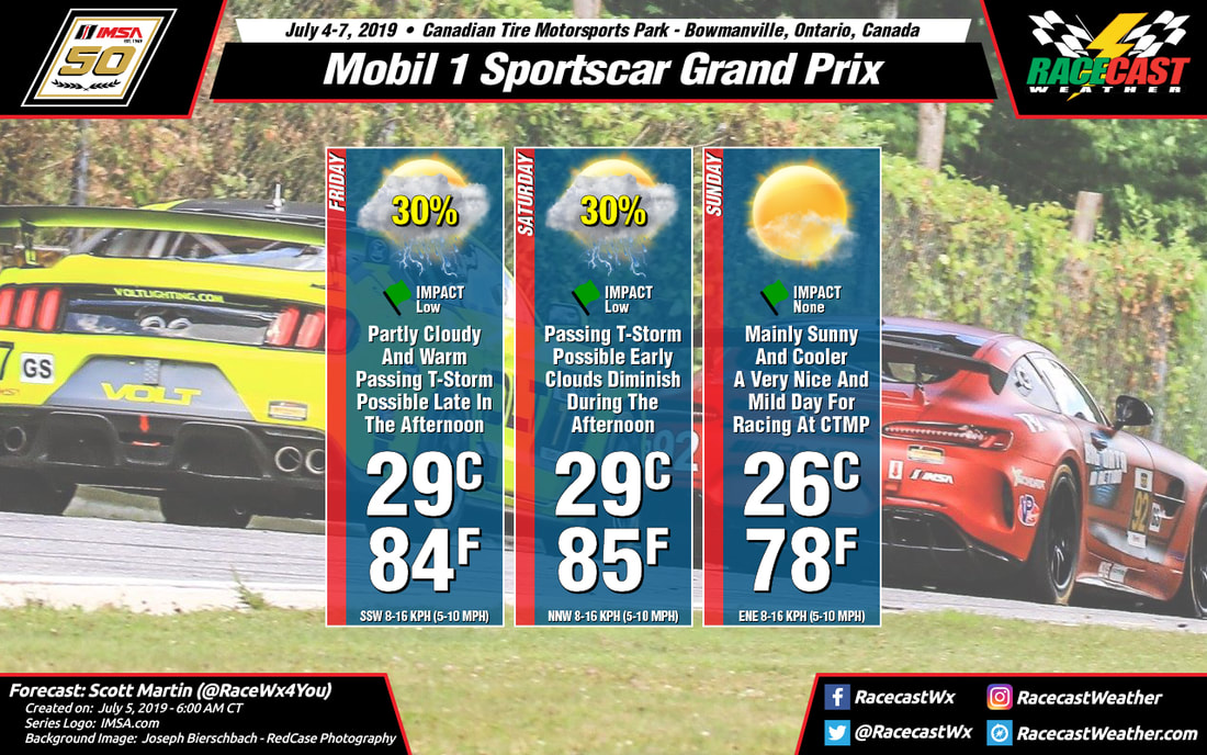
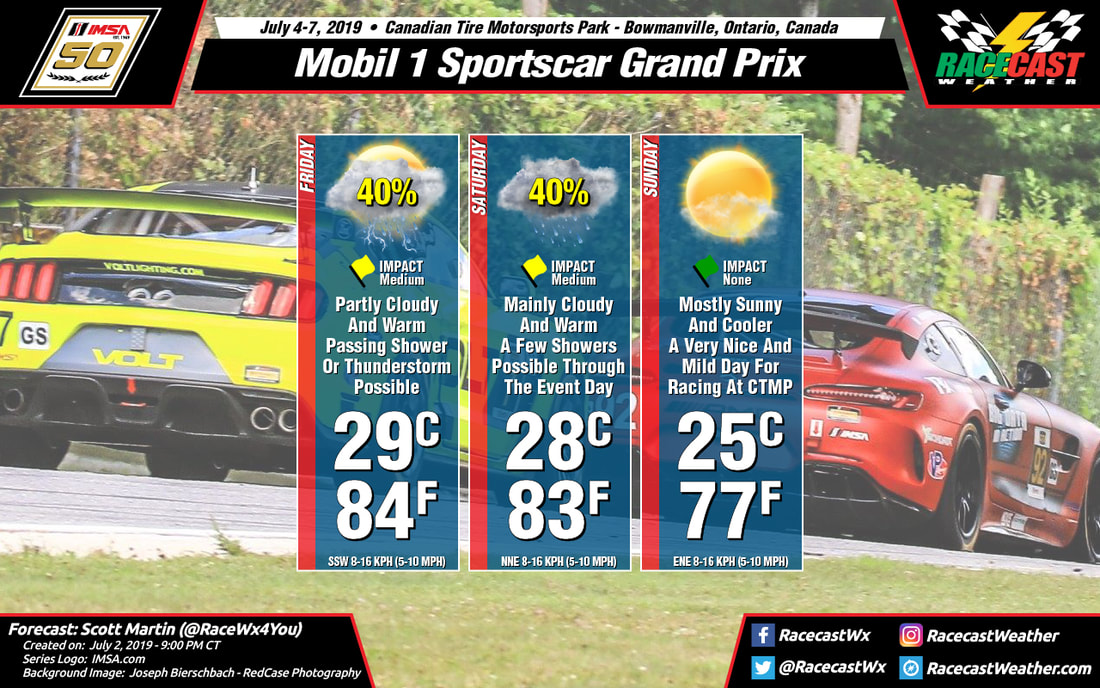
For Friday, a high pressure system at the surface will be located in the eastern Pacific with a surface low pressure system directly to the north, off the coast of Canada. The area of high pressure is expected to have a larger influence on the surface winds in the area, with them coming from the north to northwest through much of the weekend. With the systems extending into the low levels, the area between them will act as a funnel for moisture; the cyclonic motion around the low an the anticyclonic motion around the high will cause low level winds from the west. The moist air will condense as it moves up the mountains to the west of Portland, resulting in mostly cloudy conditions in the low levels during Friday morning; drier air from the northwest will cause some slightly clearer conditions in the afternoon. However, an upper level trough centered over the Pacific will bring moisture to the region from the southwest, resulting in mostly cloudy conditions in the upper levels for the remainder of the day. Conditions on Saturday are expected to be mostly the same, though low level winds are anticipated to continue from the west, causing mostly cloudy to overcast conditions in the low levels throughout the day.
For Friday, a high pressure system at the surface will be located in the eastern Pacific with a surface low pressure system directly to the north, off the coast of Canada. The area of high pressure is expected to have a larger influence on the surface winds in the area, with them coming from the north to northwest through much of the weekend. With the systems extending into the low levels, the area between them will act as a funnel for moisture; the cyclonic motion around the low an the anticyclonic motion around the high will cause low level winds from the west. The moist air will condense as it moves up the mountains to the west of Portland, resulting in mostly cloudy conditions in the low levels during Friday morning; drier air from the northwest will cause some slightly clearer conditions in the afternoon. However, an upper level trough centered over the Pacific will bring moisture to the region from the southwest, resulting in mostly cloudy conditions in the upper levels for the remainder of the day. Conditions on Saturday are expected to be mostly the same, though low level winds are anticipated to continue from the west, causing mostly cloudy to overcast conditions in the low levels throughout the day.