
By Scott Martin
The Trans Am season is starting to wind down as we have now reached the next-to-last event on the 2015 schedule. As of the latest data, there will be some rain involved through the area.
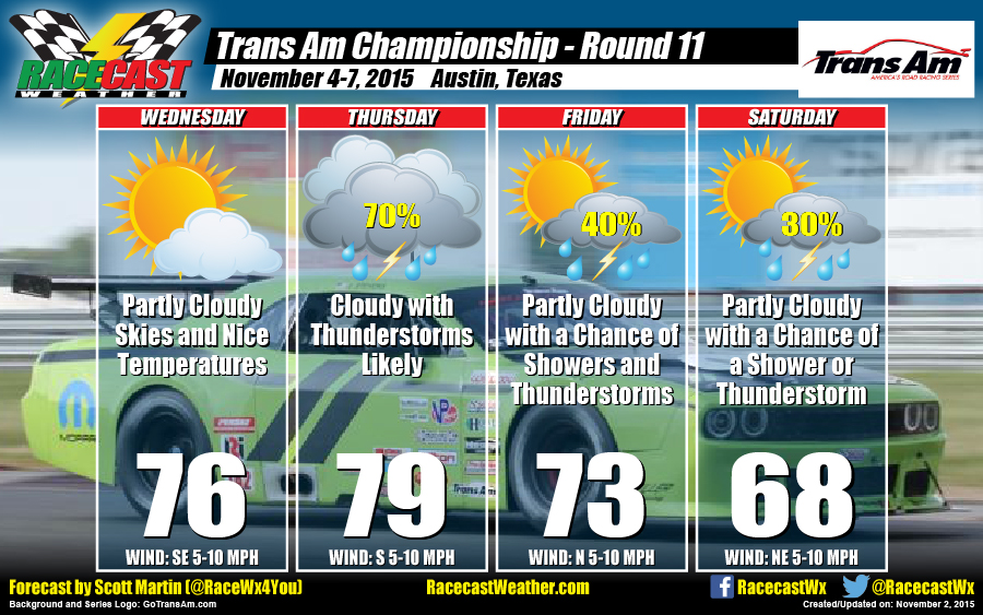
WEDNESDAY
Skies will be mostly clear to start off the day, but more clouds will start to move in as an approaching trough gets closer to the area. So expect partly cloudy skies and nice conditions. Highs will reach the mid-70s. Winds will be from the southeast at 5-10 MPH. Chance of rain is 0%.
THURSDAY
The trough will be moving through the area and bring with it rain and thunderstorms, along with a cold front. Expect heavy rain at times, with a possibility of rainfall totals over 1 to 1-1/2 inches. Unfortunately, this setup will keep decent rain in the forecast through Friday night. Highs will reach the upper 70s to near 80. Winds will be out of the south at 5-10 MPH. Chance of rain is 70%.
FRIDAY
As the trough starts to lift out of the area, there is still rain and thunderstorm chances in the mix. Partly cloudy skies may give way to showers and thunderstorms during the day. Highs will reach the lower to mid-70s. Winds will be out of the north at 5-10 MPH. Chance of rain is 40%.
SATURDAY
Conditions should start to dry out as northerly winds start to bring in drier air in. With that drier air comes cooler temperatures. Skies should be partly cloudy with a slight chance of a shower or thunderstorm during the morning and early afternoon hours. Conditions will improve as the day progresses. Highs will reach the upper 60s. Winds will be from the north at 5-10 MPH. Chance of rain is 30%.
Please be sure to follow my Twitter feed at @RaceWx4You for the latest update to the forecast.


