By: Stephen McCoy 
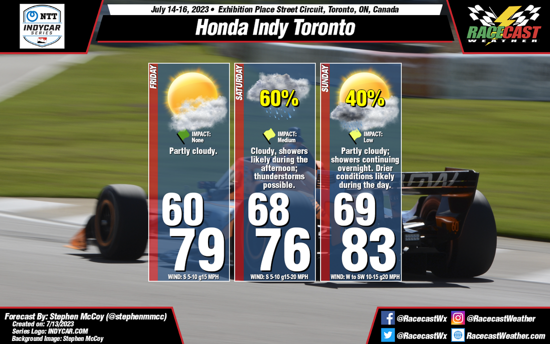
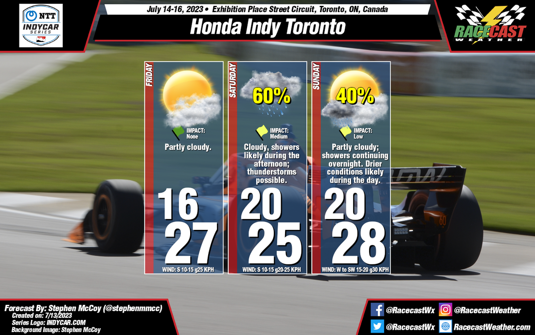
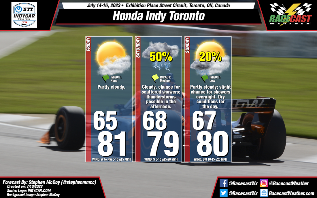
Conditions have remained mostly consistent from the initial forecast from Monday. A front moving through the region on Thursday will bring cooler temperatures on Friday morning, though partly cloudy skies will allow afternoon temperatures to somewhat normalize. A second front is expected to move through late Saturday or Sunday, bringing cloudier conditions and a chance for showers. While we would normally expect warmer conditions with southerly winds ahead of the front, the potentially widespread rainfall will likely keep afternoon temperatures cooler than Friday. A few thunderstorms may be possible in the region during the afternoon, which would certainly halt any on-track sessions should lightning get too close. Some remaining showers will possibly move through overnight into Sunday, when clearer and warmer conditions will move in.
By: Stephen McCoy Before the weekend, there will be a cold front moving through the region on Thursday, associated with a low pressure system located over Northern Canada. Conditions behind the front will be as-expected for this type of synoptic setup: winds will shift to the West/Northwest, flowing around the center of the surface low. This will cause a slight dip in temperatures overnight Thursday into Friday, but afternoon temperatures should return to near 80°F (mid/upper 20's °C). With cooler, drier conditions aloft moving in from Northern Canada, expect clear to partly cloudy skies for much of Friday.
Saturday will provide differing conditions to Friday as another front is expected to make its way through the region in the evening to overnight. Surface winds will shift to the South ahead of the front, with Southwest winds aloft providing enough moisture to keep conditions mostly cloudy to overcast through the day. As fronts are generally weaker this time of year, temperatures will stay mostly constant between Friday and Saturday. There will most likely be some development along the front, creating a chance for scattered showers, especially during the afternoon, with some stronger thunderstorms possible in the region. Much like Friday, conditions for Sunday are fairly typical for this type of synoptic setup. While there is a slight chance for showers continuing overnight into Sunday morning, daytime conditions are expected to be dry. Surface winds may pick up after the front moves through as an area of high pressure begins to move in. By: Stephen McCoy Expected conditions are far from improved for Mid-Ohio this weekend. Temperatures, winds, and cloud cover remain mostly consistent with the initial forecast, however rainfall chances and impacts have increased significantly for the latter portion of the weekend.
Friday's synoptic pattern is still likely to occur as was suggested in the initial forecast from Tuesday. A low pressure system will be centered over Ontario to the north of the region, with a surface high located over the southeastern US. The anticyclonic motion around the high will bring moisture from the Gulf of Mexico north through the Great Plains and into the Midwest. The additional moisture will result in dew point temperatures hovering in the low 70's. Air temperatures in the mid 80's with mean heat index values will approach the low 90's for a high. Moisture in the low levels will bring cloudier conditions to the region, especially for the afternoon and may result in a few scattered showers in the area. Temperatures will cool slightly for the remainder of the weekend as cloudier conditions move in. Saturday and Sunday will see medium to high impacts for on-track sessions as showers and thunderstorms are likely during the afternoons. Each day could see upwards of 1/2" of rainfall, but the main safety concern will be lightning within the storms. By: Stephen McCoy The weather setup for this weekend's races at Mid-Ohio are not looking too favorable in the initial forecast. Mostly cloudy for the better portion of the event with chances for rainfall each day. Couple that with high dew point temperatures will make for muggy conditions for at least part of the weekend.
Entering the weekend, the mid Ohio region will be located between two major synoptic systems. A low pressure system is expected to be centered over Ontario, Canada with an area of high pressure located over the Southeastern United States. The anticyclonic rotation around the high will wrap moisture from the Gulf of Mexico through the southern Great Plains and into the Midwest, where the steering flow will be partially influenced by both pressure systems. A similar pattern will extend into the mid and upper levels of the atmosphere, resulting in plenty of cloud cover over the region. For Friday, conditions will start mostly cloudy with a chance for showers as a surface trough approaches the region from the West, extending from the low pressure system over Ontario. Conditions will begin to clear for the late morning and early afternoon, which will cause temperatures to warm into the mid 80's for a high. The added moisture to the region will mean dew point temperatures will reach the mid 70's, resulting in heat index values in the mid 90's for the afternoon. Cloud cover will increase during the afternoon and evening as scattered thunderstorms may develop. The aforementioned synoptic pattern is expected to continue into Saturday, resulting in mostly cloudy conditions through the day with heat index values in the low 90's. Scattered thunderstorms are possible again in the afternoon, which may have major impacts for the on-track sessions. Similar conditions may be present on Sunday, but with slightly cooler temperatures as winds shift to the West. By: Stephen McCoy For the weekend, an upper level high pressure ridge will be located over much of the northern Midwest, maintaining dry conditions aloft. For Friday, a surface high pressure system will extend southwest from central Canada into the Great Lakes region. The anti-cyclonic flow around the pressure system will result in winds over eastern Wisconsin largely from the northeast, bringing below-normal temperatures to the region. As with the upper levels, dry air will be persistent in the lower levels, resulting in clear conditions throughout the day.
Saturday will start much like Friday with minimal cloud cover, but with temperatures beginning to return to normal as the surface high pressure breaks down over the region. With no steering factor, surface winds will be relatively calm; a low pressure system approaching the region from the south on Sunday will cause winds to gradually shift to the southeast. Much like Friday, no rainfall is expected as dry air remains over the area. As previously mentioned, a low pressure system over the southern plains will make an approach towards the Midwest on Sunday, shifting winds to the southeast. A local high pressure system will also develop over the northern Great Lakes, which will intensify surface winds from Saturday; gusts during the day could reach 20 mph. Minor cloud cover may move in for the afternoon in the low and mid levels as the pressure system moves towards the region. Rainfall is unlikely during Sunday's race, though some isolated showers may be possible during the evening. By Doug Schneider Apologies for getting this forecast posted later than usual; real life commitments can sometime get in the way of our hobby.
The weather looks great for the Detroit Grand Prix weekend. A large high pressure system will be slowly drifting west across the Great Lakes region, which will provide dry conditions throughout the event. The temperature will get very warm on Friday and Saturday, into the lower 90s. But a cold front is expected to pass through the area from the north on Saturday night, which will bring cooler temperatures on Sunday. No rain is expected with the frontal passage. Winds will be fairly light through the weekend, less than 10 mph, and generally from the northeast. By Doug Schneider The weather continues to look great for the 107th Indianapolis 500. The main changes from the previous forecast are a slight increase in cloud cover Saturday and Sunday, and a slightly lower high temperature forecast for Sunday.
The pattern across the Great Lakes and Ohio Valley region will be a large high pressure area over the Great Lakes, with a low pressure system over the Southeast states. Through the weekend, the low over the Southeast will drift toward the northwest, but the strength of the high will keep it far enough away from Indiana that rain will not be a concern at the Speedway. However, it will bring some increasing cloud cover, starting Saturday afternoon. This will be mainly midlevel and high level clouds, which will produce a milky sunshine - maybe just enough to take the edge off of full sunshine. Carb Day will be a little breezy, with a northeast wind between 10 and 15 mph, but Legends Day and Race Day will have lighter winds, between 5 and 10 mph. I'm glad that I picked a year with great weather to be attending the Indy 500 in person. This will be my second Indy 500; my first was in 2014 when Hunter-Reay and Helio had an amazing duel in the closing laps. I expect that this year's edition will be just as thrilling! By Doug Schneider The weather for the 107th running of the Indianapolis 500 is expected to be beautiful. The models are in agreement that there will be a large high pressure ridge over the Great Lakes region through the end of the week, which will provide dry conditions and plenty of sunshine for all the festivities leading up to the race. Carb Day will have the coolest temperatures in the 70s and a northeast wind between 5 and 15 mph. As the high pressure area shifts to the east through the weekend, winds will shift to a more southerly direction and cause temperatures on race day to rise into the lower 80s, with a slight increase in clouds.
Check back through the week for updates. |
Social Feeds
Authors
Doug Schneider Partners
Categories
All
Archives
December 2023
|