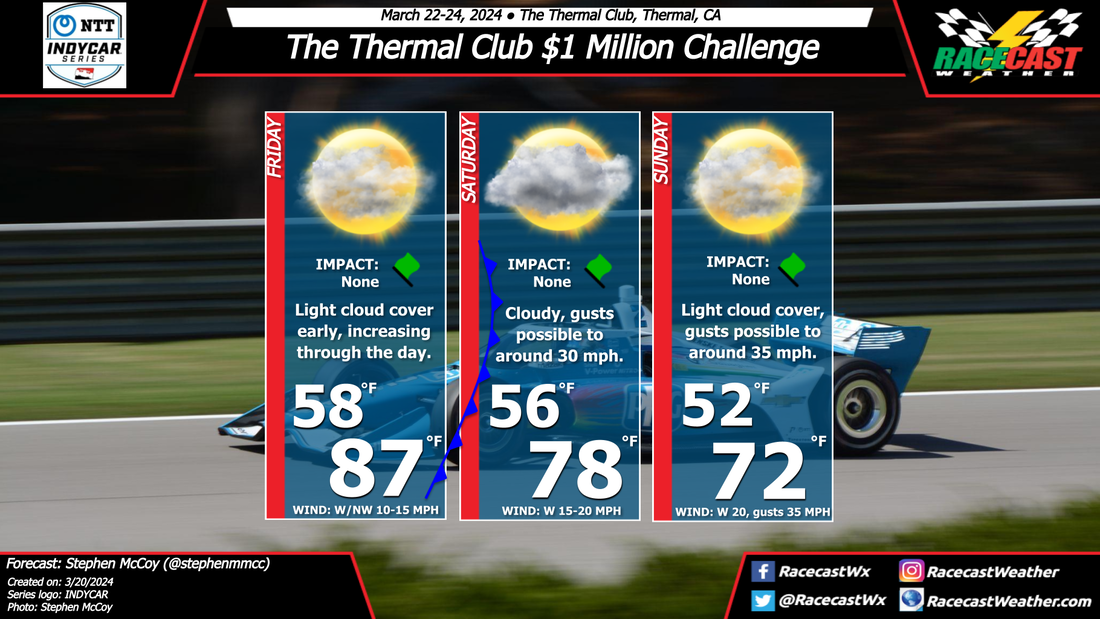
By Doug Schneider 
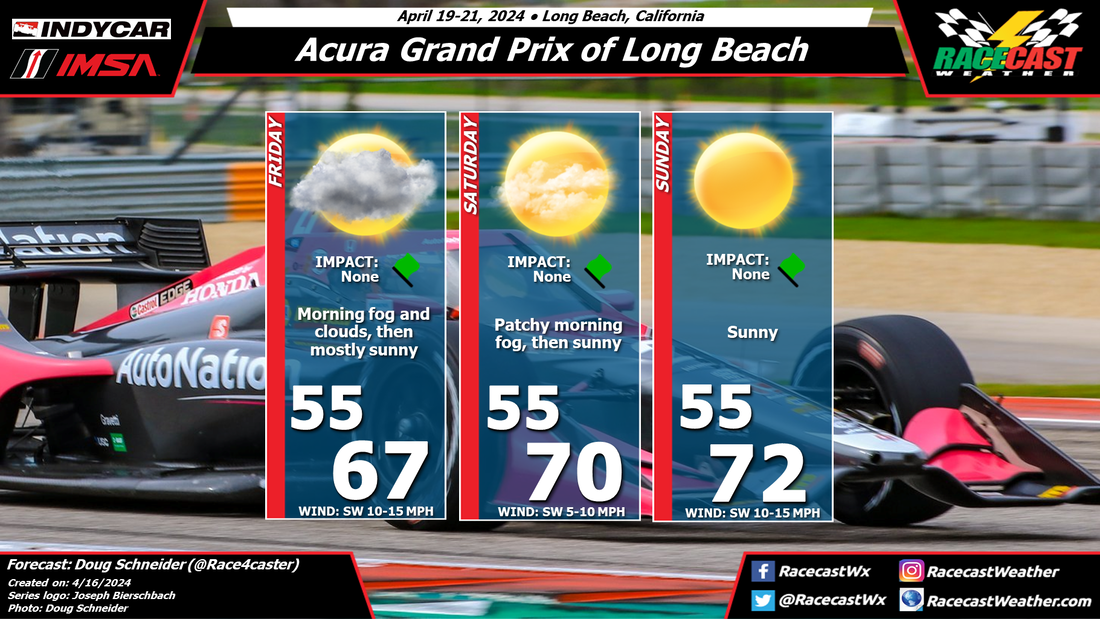
Nice weather is expected for the Acura Grand Prix of Long Beach, fairly typical for the area. The pattern will be a building high pressure ridge through the weekend, resulting in greater sunshine and warming temperatures each day. The start of activities on Friday morning may be dampened by fog and low clouds, but by afternoon, the clouds should lift and leave mostly sunny skies the rest of the day. Saturday could have some fog to start the day, but it should lift within a few hours of sunrise. The chance of morning fog is lower on Sunday, but it can't be ruled out entirely. Temperatures will be pleasant through the event, from the upper 60s on Friday to lower 70s on Sunday.
By: Harris Cooley Low pressure over the area will keep clouds in the forecast through the weekend as moisture content will be high. Wind speeds will be quite low with temps staying constant around the upper 50's. Cloud coverage and mild temps could bring some grip issues as tires will have a harder time staying warm, let along if any drizzle falls on the track. Sunshine is expected to poke through for Sunday afternoon though so that will be important to keep an eye on as race time nears.
By: Harris Cooley Steady southerly winds will last through the weekend with gusty wind speeds in the afternoon. Cloud coverage sets in for Saturday and Sunday as southerly winds bring moisture ashore. Rain chances are present but low for Saturday afternoon as a result of the increased moisture and gusty winds. Sunday will be partly cloudy with gusty winds for race time, though nothing too impactful to the drivers.
By: Stephen McCoy A new track brings new conditions for the drivers and crews to face for this weekend. Above average temperatures on Friday will give way to cooler, breezier conditions for the remainder of the forecast period after a cold front passes through southern California Saturday. Light westerly winds along with light cloud cover will be present Friday morning, with both increasing ahead of the approaching surface front. Overnight temperatures will be fairly stable and similar to Friday, however the passing of the cold front will cause maximum temperatures on Saturday to cool around 10 degrees as cooler air moves in from the west/northwest. Skies will remain partly to mostly cloudy, potentially with virga falling beneath the cloud deck. This is due to the dry, desert-like conditions of the local area keeping any amount of precipitation from reaching the surface. The pick-up of winds behind the front are expected to bring some stronger wind gusts for the afternoon, which could result in patchy areas of blowing dust. There is potential for similar conditions on Sunday, but with cooler conditions near 70 now with the front fully passed through the region.
By Doug Schneider Click images to enlarge High pressure will remain in control of the weather across southern and central Florida today, providing mostly sunny skies and warm temperatures for today's race. There may be some morning fog in the area around sunrise, but this should burn off quickly and be gone by the time the pre-race activities start. High temperatures this afternoon will be near 90 degrees F, or 33 C. For those who are camping at the track into Sunday, the weather on Sunday also looks dry and warm, pretty similar to today.
By Doug Schneider Click on images to enlarge Rain-free conditions are expected later this week for the Mobil 1 Twelve Hours of Sebring. A weak disturbance could bring some light rain or sprinkles at the track on Wednesday night, but by the time racing starts on Thursday, any chance of rain will be gone. A high pressure ridge will be over Florida through the rest of the weekend, providing very warm temperatures each day and mostly sunny skies.
One thing I've learned from years of forecasting at Sebring is that the temperature often gets hotter at the track than the surrounding area, so you may see other forecasts out there that have slightly cooler temperatures. I think the Sebring "heat island" effect will add a few degrees to the high temperatures, with highs in the upper 80s to lower 90s F (lower to mid 30s C). By: Harris Cooley Northerly winds will be blowing strongly today thru the race. Clear skies will be present all day today with warm temps as the afternoon progresses. High wind speeds will cause grip issues on the track paired with drifting sand across the track all afternoon. Conditions will be quite good for the remainder of the race.
By Doug Schneider The weather looks great for the INDYCAR season opener on the Streets of St. Petersburg and the Albert Whitted Airport. High pressure will be over the western Atlantic Ocean to start the weekend, providing a warm southerly flow and mostly sunny skies on Friday. As a cold front approaches from the northwest, winds will pick up on Saturday, along with increasing clouds. A few light showers with this front will be in the St. Pete area late Saturday night, but the front is expected to pass through the area around daybreak. No impacts are expected to any of Sunday's on-track activity. Sunday will start off with some clouds, but dry air will build in, and by the time the race begins in the afternoon, it will be mostly sunny. Northwest winds of 10-20 mph can be expected during the race.
|
Social Feeds
Authors
Doug Schneider Partners
Categories
All
Archives
December 2023
|