
By: Stephen McCoy
The updated forecast for the ABC Supply 500 remains mostly consistent with the initial forecast, though with some warmer temperatures both days and a slight increase in precipitation chances on Saturday.
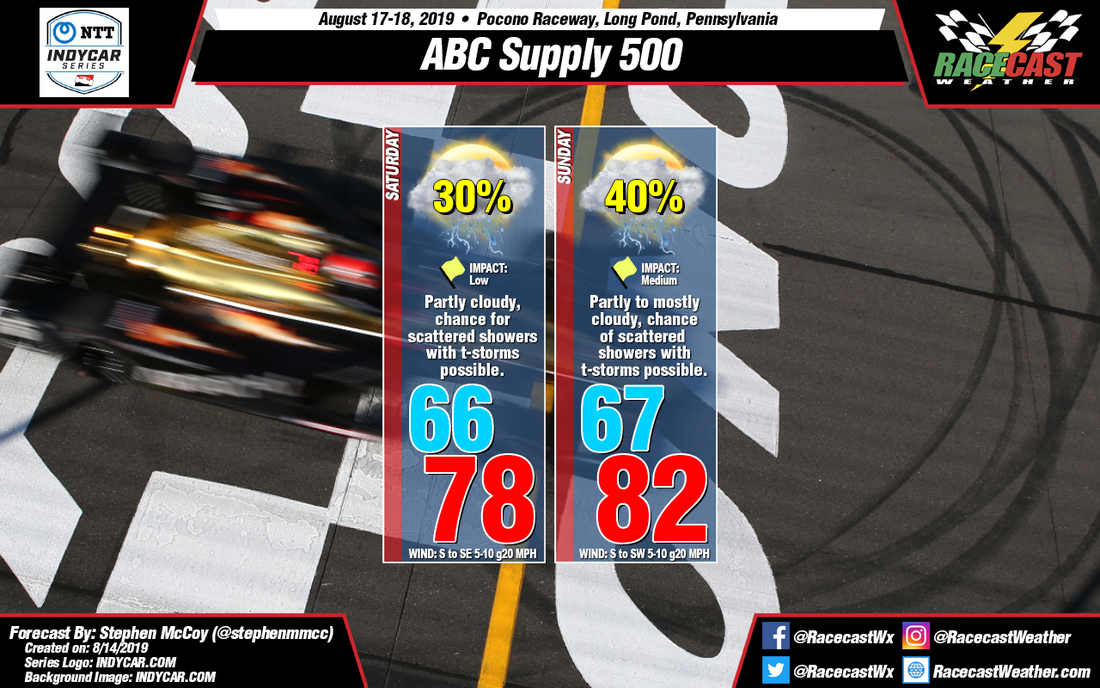
The atmospheric set-up for Saturday is similar to the previous forecast, with winds from the south to southeast now throughout the day, which will result in warmer air temperatures. Dew point temperatures are also anticipated to be warmer: mid-60's during the morning increasing to the upper 60's to low 70's in the afternoon. The low levels aren't anticipated to be as saturated as in the previous forecast, however with warmer temperatures, the chances for convective precipitation have increased. Mixed-layer CAPE values indicated by the GFS are now upwards of 1000 J/kg for Saturday. The NAM shows MLCAPE values well under what the GFS is predicting, though surface CAPE values are similar. Regardless, conditions will be similar to those seen today: hit-or-miss showers with a few thunderstorms possible. The models seem to indicate two standout times for precipitation: mid-morning and late afternoon. Impacts remain low as the uncertainty of where/when rainfall occurs is still high, however if showers do occur they will likely stop any on-track sessions. Much like in the previous forecast, fog is possible during the morning.
Sunday's set-up has changed since Monday, as the aforementioned surface low pressure system is now expected to weaken as it approaches Quebec. However a high pressure system sitting over the central Atlantic will cause winds from the south to southwest, resulting in warmer air temperatures for the day; dew point temperatures near 70F will continue from Saturday. Precipitation chances remain the same, though showers and/or storms will be initiated by convection as opposed to the cold front mentioned in the initial forecast. CAPE values are expected to be higher than those for Saturday and may lead to stronger storms. Impacts remain the same due to the models suggesting the highest chance for precipitation being in the early to mid afternoon. Should rainfall occur on Saturday, fog may be possible again on Sunday morning.


