Click images to enlarge
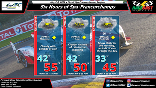
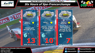
On Thursday rain showers will be on and off at the track all day due to a cold front and a upper level trough approaching from the north. Rain amounts on Thursday are likely to be the highest of the whole event, and will probably be in the range of 3 to 6 mm (a tenth to a quarter of an inch).
The cold front is expected to cross through Belgium on Friday morning. Once the front moves through, the chance of rain will decrease. While I can't completely rule out some light rain or sprinkles through the day, I don't think there will be much impact on the action in the afternoon.
A second cold front and a deeper upper level trough will move into the area on Friday night. The combination of colder air and greater moisture moving in from the north will likely bring some snow to the track on Saturday morning. The uncertainty with this snow potential is what the temperature will be at the ground, which will affect how much snow accumulates, and how long the snow may last before changing back to rain. I expect that the temperature at the ground will stay just above freezing Saturday morning, which will prevent any snow accumulation on grass surfaces. Certainly, the track surface will be too warm for snow accumulation, but reaching optimum tire temperatures will be a struggle all race as temperatures will only be in the 40s F or single digits C. Timing of a change of snow to rain is uncertain, but the late morning to early afternoon hours (10 am to 1 pm) are the most likely period for this to happen.


